Kinder Scout Eggs

There’s a direct line from Brinnington to Hope. A world of differences between Ashburys and Marple. Too few similarities between Reddish North and New Mills Central. Yet the line from Manchester to Sheffield offers gems and escape. Friday the 25th of April 2025 led a path between Piccalilli train station and the quaint village of Edale.

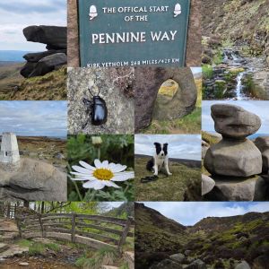
Upstream to Grindslow Knoll, required a short wander through the village of Edale, passing the beginning of the Pennine Way. The Rambler Inn, The Nag’s Head, and Newfold Farm Cafe give a feel of what the tiny village of 400 centres around. An old and active primary school, set amongst the varied farm houses, country cottages, and Edale Parish Church show that life here isn’t all wandering. A path diverts from a truncated road over Grinds Brook. The protected stream will accompany mist walkers until Grindslow Knoll.

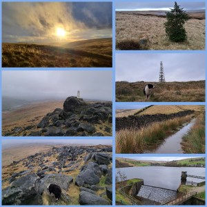
The paths start gentle with some undulating, before rocks, boulders, and scree start to appear intermittently. Heathers and moorland flora decorate either side of the funnelled valley. Eventually the bulk of Grinds Brook splinters into two sharp rises. Banking left involves a scramble, some choice pathway making skills, and a substantial incline. The views are increasingly dramatic. At the top, looking toward Mam Tor and Edale, much of the distance appears green and sprawling.

Following an old slabbed walkway, the journey takes explorers to a rock formation known as the Woolpacks. Peat bogs, heather, and alien-looking rocks litter, cluster, and emerge along the Kinder plateau. They mark the final wander to the peak of Kinder Scout and are a highlight for many walkers. Mermaid’s Pool, Charged Rock, and countless unnamed landmarks are worthy of an exploration.

The descent from Grindslow Knoll’s shady rear allows for farmland wanders along wide open pathways and a gentle jaunt on the home straight. Edale awaits. Edale sounds like a cake. The delicious Penny Pot Cafe banana and date oat flapjack was the only cake I had that day. Succulent. Alongside a cappuccino it made for a great reward. Before boarding the 1647 train, Panda found many a crumb landed in his fur. He promptly removed them before flopping back, head on the floor, for a nap.

Windy Hill & Blackstone Edge

Turning right from Newhey Metrolink Tram station, a short ride from Manchester, Panda, and I walked beyond Bird In Hand and The Bird In The Hand signposted public houses of Newhey. We carried on until an old stone bridge and turned left off Huddersfield Road (A640) onto a cobble path parallel to Piethorne Brook. The Brook ran behind a campsite, industrial estate, and eventually a steep cobbled road swept up over Ogden Reservoir.

Ogden Reservoir, in the Piethorne Valley, sits at the lower end of a strong of water bodies. Our path climbed west and away from the giant puddles. Crossing the Brook west of Ogden Reservoir, up some steps and beyond abandoned building foundations, the path stretched upwards towards Tunshill Lane. This battered old farm track lined with rock, split off at 53.6164428, -2.0610034. Here, the road became abandoned, waterlogged, and an ideal testing point for waterproof footwear. The odd abandoned jeep carcas lay along the way, and long lost gate posts led to nowhere in particular. After a gentle ascent, Windy Hill Transmitter sat atop a top, 389 m (1,276 ft).

Banking left from the Transmitter, the Pennine Way Bridge with splayed leg carried the Pennine Way footpath towards Blackstone Edge (1549’/472m) and whisky cave. The low cloud, fierce hailstones, and torrential precipitation tested my face for feeling and hands for the ability to withstand harsh weather. Panda bounded around joyfully despite the brutal onslaught of uncomfortable weather. The gritstone boulders make for suitable shelter in thunderous winds. The Lancashire-Yorkshire border hosts great views of Manchester, although at times, dark clouds hid the growing skyscraper-lined skyline.

The Calder, Aire, and Ryburn have origins here. Each flow east to the North Sea. Similarly, Roch and Irwell have feeder streams here, destined for the Irish Sea. Having read bits afterwards, I recommend a spot of research before rambling and looking for diverse routes to the top. There are plenty of inspirations out there. I opted for the look at a Metrolink stop and study an Ordnance Survey map for interesting features, then get out and follow a map in my head. An inspection of the weather forecast may have been wise, too. The Craghoppers rain jacket I modelled did the job, though it was touch and go!

Once you’re up, you need to take in the views, snap a few shots, or, in my case, cling to a phone camera and pray the winds didn’t rip it from my hands. The hailstone became sleet and then sideways snow. Hands numbed fast. My face felt battered. An about turn and a descent, against altitude and fading light later, and Panda and I boarded an evening tram back to Manchester. Not a bad afternoon wander. 4 hours or so, all in. So, where next?