To be determined.

你好/ Ní hǎo / Nín hǎo / Hello / How do / S’mae / Namaste,

https://sunyatsens.com/

I opted not to take headphones with me, or earphones for the trek around Nepal. The soundtrack would be life and nature. However, if I was to take one song on that journey, then I’d struggle. Today, I watched the video of Ting Bu Dong by Sun Yat Sens. The track opens with producer Ryan Chambers on the didgeridoo. Throughout the track he continues flitting between this instrument, an acoustic guitar and backing vocals. Sometimes he manages two of the three. Talented bugger! Some of us can’t even play the spoons. The vocals kick in from Chris Bradshaw, who puts a J between his names. It could mean juggernaut or John, as in Lennon, I don’t know. Rob Laughlin on base, alongside Eric Charette on drums and a session guitarist in Brandane Mullane form the band’s entirety. The reason that I namedrop these guys, because somehow, somewhere and someday these boys could reach high. They’ve evolved since I first watched them at Magic Island Music Festival back in December 2016. They’ve gone from a group capable of pub gigs, to a professional looking, well-marketed and confident outfit. They’re more A-Team than A-list still. That’s a good place to be. With videography by the talented Ryan and drone footage, alongside their graphic design they can do anything they want.

The dreamy didgeridoo-opening has a touch of This Garden by The Levellers, and I’m feeling a touch of Dido in there. It has the played down nature of early Oasis-acoustic tracks without the overpowering aggression of a cocksure Gallagher on board. I’m expecting, “Today is gonna be the day…” but instead the song smashes in some Chinese. Why not? The reggae-indie rap is dreamy. The chorus is clear and takes me back to Nepal on that last walk. Songs that unlock memories and emotion are powerful things. The video showcases life in China, a wandering figure and gives your imagination an opportunity to test itself. Sun Yat Sens and their previous song WeChat was more Feeder and jolliness in style. My students feature somewhere in there around the minute mark. I hope that we all see and hear more of this band soon.

#15 – PYRAMID – GORAK SHEP 1300 – EVEREST BASE CAMP – GORAK SHEP 1800 ~ 12km


8th February 2019

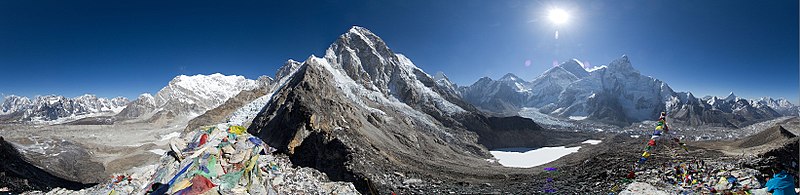
We set out from Pyramid (5050m / 16,568ft) to Gorakshep (5100m) and then onwards to EBC (5360m). On Earth’s lands there isn’t much surface area above us at this point. The upper points above 7,000ft (2133m) is only about 7% of the total of Earth’s surface. 29.2% of Earth has land above sea level or uncovered by lakes and rovers. Our oblate spheroid of a planet has bumpy bits. The Himalayas (China/Nepal/India)) with the Karakoram range (China and Pakistan) are the only places to see peaks over 8000m. Only Bhutan, Kyrgyzstan, Afghanistan and Tajikistan (a country I know nothing about) can be added to those countries for mountains over 7000m. Going to other countries and looking for big mountains is near pointless. Aconcagua (6962m) in the Andes (Argentina) is as close as you will get. Anyway I now found myself above 5164m for a night’s sleep. The highest that I have ever snoozed.

If Lobuche is bleak, then Gorakshep could have meant shithole in English. The smooth mountain top of Kalapatthar hovers over the lakebed that sits by Gorakshep. We arrived, ditched our things at the Buddha Lodge, ate a late lunch and then started the Everest Base Camp trek. The final leg towards a hidden shadow beneath Everest. The lodges are mostly supply drops and shelters. There is discarded waste in piles, banners and tents ripped to shreds scattered here and there. Armageddon refused to stop in Gorakshep on account of it being totally dilapidated and uninhabitable.

The worst night’s sleep ever followed. Firstly, the windows were rattling amd pccasionally flying open. Cracks in some panes threatened to explode. The roof was rattling. Each room had a temperature lower than -25°C. Snow slipped through the edges of the window frames. The lodge shook with each gust. Worse still – we were running out of yak shit. The main lounge room was starting to cool. As I lay my head down headaches came and went. Even if I wanted to descend downwards, this was not the weather to open any doors.

In the lodge a group of three from the U.K. with their The Baton flag slept, alongside Rhys, Al and Spanish Albert. Everyone seemed to endure a restless night of anti-sleep. Hope of making ot through a night without the roof blowing off was broken up by regular piss breaks to the toilet at the end of the cold corridor. The frozen stinking cesspit in the ceramic western toilet was perhaps the warmest thing for several kilometres.

The great thing about having a sleeping bag comfortable to -25°C is that when it finally teeters over that temperature limit, you’re still a little warm. An extra blanket on top helped. The noise of the howling winds did not. Gritty frozen grains pounded the windows outside. It seemed that the outside desperately wanted to be inside. Sporadically the dirt of the outside world slapped the windows like bullets being fired from a gun.


9th February 2019

Morning arrived. Breakfast was devoured. We set out.

Kala Patthar is 5,545 metres (18,192 ft). It might as well be higher. It is no mean feat to get to the top and capture a panoramic view of the Khumbu glacier like all the postcard shops have obtained. A panoramic sweep of clouds in all directions and zero visibility doesn’t sell the same. To quote trekker Rhys from Cardiff, “Well it is the mountains and that means clouds.” It is what it is. Simple. Black rock, as Kala Patthar means in Hindi, might well just translate as bleak rock. I read somewhere that the ‘The world’s highest webcam, Mount Everest webcam, was located here’ on Kala Patthar. In those clouds, you could lose anything – including life! No prayer flags were visible yet needed. No mountain climbing permit was required – making this the highest point to scramble without license to do so.

The Khumbu glacier is supposed, by scientists, to have formed in the last Great Ice Age. That was around 500,000 years ago. On reaching Lobuche (4910m), my legs were feeling equally as old. The Khumbu region stretches from Namche Bazar out to Thame in the west and Gokyo. Gorak Shep, and Chukung mark the northern and western areas.  The Khumbu subregion is a third of the region known as the closely named Khambu. The lowest point is 3,300m high around Lukla. Visibility was so low, that my feet were barely in sight. The gamble and decision to stay an extra day was not appealing. With heavy snow forecast, we headed down – our target, “as far as we can go.” Well, after struggling over the open boulder and rocks fields lining the banks of glacial death below, we dropped into a valley leading towards the Pyramid. We’d later show some pretty bad windburn on our skin – and thankfully we escaped anything more serious.

Having sought cover just before lunchtime, we had cut a path through deep snowdrifts and found shelter. We were the only ones at the Pyramid International Laboratory/Observatory. We hadn’t intended to stay again but we had no choice. After an hour a Chinese man and his porter/guide joined us. They said they were close to death out there. It was believable and no embroidery on their part. Barely two hours later and the blizzard vanished. The whiteout faded to a grey unsettling day. We chilled out in the warm lounge watching cricket, volleyball and eating too much. It passed the time before bedtime. Outside did not appeal to us.

#16 GORAK SHEP – PYRAMID ~ 10km

This slideshow requires JavaScript.

10th February 2019

The walk continued as in the spirits of each day before. It was always about just going forwards, and not rushing. Some loose targets and aims were handy but they were never set in concrete. The journey was to be lived. The destination was just for inspiration. Some target Everest Base Camp for status, spirituality or homage. Some push themselves as far as they can go. Some want to do their best. There had never been a race to get anywhere and likewise we weren’t descending fast for the sake of it.

Within an hour, I did not think that I could walk any more. My head was pounding at the rear and I was walking so slow, that deep down I was beginning to worry. Fatigue had turned to exhausation and my mental condition was slipping to the negative. Ten minutes after passing Ishwor, Srirang and Livia on their way up, I had to stop. Here the cough that had been niggling me for nearly two weeks began to rasp at my throat. I tried to catch my breath. A moment later, I was staring at my breakfast on the floor. My nose stang. I smelled terrible. My mouth tasted like a yak’s arse. After a few moments of composure, I explained to Maria we must head down fast – but steadily and for her to keep an eye on me. Barely an hour later and I felt great – reinvigorated and fully oxygenated. Resurrection in a Buddhist land is possible afterall.

We soon appeared at the tombs and monuments, standing tall under a sunlit sky. The spiritual air of the location fell away as we descended the pathway to Thukla. Here we continued over the glacial rover’s stepping stones, banked left and followed a pebble-stoned pathway into the valley around Pheriche (4371m).

I was told by many not to stay at Pheriche when doing this trekking route. It sits deep in the shadows of the mountains around it and on a cloudy day, little light makes it to the village. This day it was basked in splendid sunshine. The Tsola River flowed beneath it. The Himalayan Rescue Association (HRA) are based here but we dodn’t stop by. We spent an hour hiding from yaks, by squating by a frozen stream as they passed by and then doubled back. Eventually we joined a British couple, their guide and porter to pass by. The top end of Pheriche village seemed to have a melting-yet-dangerously-frozen-river-road down the middle. That had to be negotiated slowly. Empty buckwheat and potato fields lined the pathways. Following the top end of the village a few kilometres before the lower village appeared. The neighbours there must be quite fit.

Arriving at Deboche (3820m) today we had dropped about 1230m. That’s 1.23km (4053 feet – about 7/10 of a mile). Burj Khalifa is the tallest building at 828m (2717’) tall. It had taken just a few hours. The walk up had been broken down.

#17 0900 PYRAMID – 1600 DEBOCHE; #18 0930 DEBOCHE – NAMCHE BAZAR 1700: ~ 40km
#19 NAMCHE BAZAR – LUKLA ~ 21km
#20 LUKLA: ~ 4km

More to follow.


再见/ Zài jiàn / Bài bài / Ta’ra / Goodbye / Hwyl Fawr / Dhanyabaad / Alavidā

The Great Pyramid of Nepal?

你好/ Ní hǎo / Nín hǎo / Hello / How do / S’mae / Namaste,

It could be argued that too much looking back is bad for the soul. Well my mind is also investigating a possible wander to Détiān pùbù, Bǎnyuē pùbù [板約瀑布, 德天瀑布]. This is located the Daxin County, Guangxi and Vietnam. The Lanning Nandong station may be a useful starting point. The Green City awaits. Then there is Zhēnzhū Tān Pùb [珍珠滩瀑布] too. Oh and Huáng Guǒshù Pùbù [黄果树瀑布]. Anyway they all need further research, and now I can carry on telling the tale of this year’s trek in Nepal.


4th February 2019

The early morning pathway from Namche Bazaar is wonderful. However, we set off at 1130am, touching the afternoon. Having sat in Namche Bakery eating apple strudel and celebrating Ishwor’s Not-Birthday. Srirang and Livia had checked Facebook and assumed the date of birth he had published was his birthday. Turned out it wasn’t. Not that a candle in some chocolate cake wasn’t fun. We sweet off late having shared a fun morning with a birthday party that wasn’t quite right. We walked for a short time and enjoyed lunch at Kyangjuma in a lodge’s garden that I’d previously ate at two years ago. Thamserku was in clear sight and Ama Dablam lay dead ahead on the trail just beyond the Tyangbuche (3860m) brow and the huge monastery.

The owner of the lodge talked with me about how his dog, that I met two years ago, had been eaten by a snow leopard – and the two similar dogs were that dog’s offspring. We talked about the New Year celebrations in Sherpa culture, his hair being died and general local information. Stupas were soon, once again being passed on the left, as we bid our farewells and descended downwards to a river crossing.

We passed Thunki Tanga, which like everywhere seemed to have many variants of spelling. Funky Thanga seemed the best name. Completing the checkpoint registration, we began the slog of a climb up to Tyangbuche. Here we met Albert from Spain, who had walked from Thame. We also met a Sherpa man who had climbed Everest on several occasions when he was a few years younger. He’d walked from Lukla that day and would head as far as Pangboche. One hell of a jaunt! Our destination would be Deboche – and ideally at the Everest Lodge.

May people refer to this part of the trail as ‘Nepal Flat’. You really speaking only gain about 330 metres of altitude. There are woods galore, steep valleys and on this day the bright sunshine gave lovely sweeping clear views. Everest and Lhotse had been dead ahead for some time, until we sank down to Phunkitenga (see, another spelling!) – and here it was all up for a few hours.

On arriving in a darkened Deboche we checked into Paradise Lodge. I have a few tiny criticisms of the name. It was too cold to consider as a place of nirvana, but the warm log fireplace gave glory, I guess. The twelfth Dal Bhat was adequate for filling the belly.


5th February 2019

Today’s walk bid farewell to trees somewhere just beyond Pangboche and touching Otso village. The trail is the first day of true discomfort. You adjust and pace yourself with much more care now. The air is getting noticeably thinner. You concentrate on slowing your pulse and breathing with more effectiveness. There is touch of anxiety about me. This is where in 2017, I reached. And not much higher.

Deboche to Pangboche and finally Dingboche (4410m) is a photographer’s dream. There are gompas, vast valleys, huge rockfalls, streams and views of Ama Dablam up close. Then, as you climb into the valley that holds Dingboche, you see the mountainous borders of China with Island Peak, and Nangkartshang looming overhead.

My sleep that night wasn’t bad. No headaches and a confidence that this would be the year. Maria wanted to go on today. I insisted that we acclimatise. Over-confidence can be your downfall. Breathing normally is on the cards for tomorrow. Dal Bhat the 13th, was certainly no nightmare. It would assist on the battle against altitude-related doom.


6th February 2019

Coaxing the morning breaths into a steady rhythm, I tucked away breakfast. Last night we met Rhys and Al, who had travelled from Wales to climb to Everest Base Camp for charity. This morning we set off together to go up the neighbouring mountain. Nangkartshang is an unwelcoming rocky mountain lined with grass at first sight. The walk started vigorously. Our bodies would need the climb up, feel the strain and then sleep low. Every step would soon be an exertion and the higher we went, the harder it felt. On reaching the summit and ledges, the views are out-of-this-world yet remind us that we are on this world and we’re quite small. The cold air and clash of bright warm light make for an up and down body temperature. I regret wearing the down jacket – yet later, I was thankful for this piece of clothing.

As we descend the valleys beneath us fill with cloud. It filters from many directions and eventually covers the sky blotting out the fading evening sun. Winter is coming, so they say and the next day we will wake to fine flakes of snow. Everyone at the lodge talks in whispers of a big snow storm in the region over the next three days. A couple, from China, who are descending talk about a Pyramid lodge to stay at. We take the details and set that as tomorrow’s aim. But will the snow be too much? At least the fourteenth helping of Dal Bhat would surely help get me there.


7th February 2019

Dingboche to Thukla started in light snow. The snow eventually faded yet the sky remained jaded. My cynical mind remained open to further snowfall. The great sweeping plains above Dingboche, lay beneath mountains to the right shoulder, and beneath my left shoulder, a drop down to the river valley below. The left side view of Taboche (6495m) and Cholatse (6440m) gave a dramatic slant to the world. Cho (lake), la (pass), tse (peak) are Tibetan words. They’re impressive peaks and highly photogenic. The ravine of the Khumbu glacier folds away as we ascend to Thukla (spelt in numerous ways, as always) and onwards to Lobuche. The climb is gradual and striking. There are remarkable pathways cutting through the snow. But, before the bigger climbs, we stop for lunch at Thukla.

Upwardly walking in clouds and snow is unearthly. It heightens your senses and brings the imagination out. Beyond the cloud could be a sunny day, Godzilla or the Manchester City reserve team. You have very little way of knowing. To quote Meat Loaf, ‘what you see, is what you get’.

The cloud lifted and a strange black square shape could be seen. From this parapet a stream of colourful flags fluttered down. They formed a line stretching to a shrouded stockade to my upper right side. These ramparts appeared to be stones stocked one upon another and squared off with rough edges. The first two stupas formed a gateway from the pathway leading up from Dughla.

To my left, the flag of New Zealand fluttered. Rob Hall, of the famous Adventure Colsuntants was marked here. From the 1996 climbing disaster on Everest was the Mountain Madness Everest Expedition leader Scott Fischer. Both bodies of these remain on the South Summit of Mount Everest. There are others from this and groups of other deadly climb attempts. There are touching tributes, grand notes and plaques. I tried to read as many as I could. I was spellbound. It was sad but also life-affirming. It made me ask questions and think things that I seldom think or have never thought. The cloud drifted out to reveal lines of cairns and stupas. Suddenly, I was in a living graveyard. I felt that I was in a dizzying field of tombs, like the iconic Sad Hill Mexican standoff (which was filmed in Spain) in the the movie The Good, The Bay & The Ugly. Dizzying is a word that I have used lightly before. On this occasion, it felt apt for my vertiginous and flighty state of mind. I thanked the Gods (all of them, that others respect and worship) for people remembering the fallen, doing the thing that loved the most. But, does anyone really want to die doing the things that they love?

More than 290 people have died attempting the Everest peak – or assisting those who climb it. Official statistics of deaths amongst the trekking population, that go to see Everest, are unknown. It is expected to be around 4-5 people a year, from altitude sickness. Crevasses, mountain sickness, being struck my your own icepick as you fall, avalanches, exhaustion, death by Serac, disappearance, falls, drowning, heart attacks, blood clotting, exposure to the elements, rope accidents, and others reasons for not wanting to climb Everest may have deterred me. For climbers, they must climb. Those lucky enough get to trek and explore wonderful places with blotched histories and wonderful moments. This is the spirit of nature. It takes and it gives.

On reaching Lobuche we step into the Oxigen Lodge and have a brew. We decide the snow is lighter and crack on for Pyramid. It should be around an hour away. Lobuche is a near barren wasteland. It is unwelcoming and borderline unfunctional. This town is notorious with early trekkers and climbers as being the place where everyone inhaled yak shit dust from early fireplaces. It has improved dramatically in recent years but still has a feel of drabness. The frozen toilets, a stream full of ice and a pocket in the snow with a dozen stray puppies gave an air of menace. Here you are expected to tolerate the simplest of simple accommodation – complete with ice. The trite options surrounded by inclines mark the start of the really, really dangerous glaciers – so we didn’t hang around too long.

After about 30 minutes we reached a ginnel, a short passageway to our left. Two clear signs pointed towards EvK2CNR and SHARE. It is possibly mothballed by the Italians, but it seems active. We walk the pathway for about 10 minutes. We had to cut through the reasonably deep snow. On arriving the squat brick building with a glass pyramid looked lifeless. On opening the door, it was far from lifeless. A dozen or so noisy Chinese voices mixed with a few western accents. We met Spanish Albert, Al and Rhys once again. Amongst the crowd were many friendly porters and guides. The lodge manager pointed us to the warmest room on the entire trail and apologised that the solar panels were too deep under snow, so the internal heaters were not working. It was more than comfortable. A bucket shower and all meals were inclusive – for 4000 NPRs per person, per night. That’s £26GBP or there abouts. Luxury in an amazing setting.

The Pyramid International Laboratory/Observatory is a high-altitude research centre. It has the aims of promoting sustainable development within mountainous areas. It is there to safeguard high altitude ecosystems. These areas for some of the most fragile in the changing world. There are works on the wall. I sit reading through them on eating Dal Bhat 15 and trying to find City’s score versus Everton away. The score flashes up. City’s title battle continues. Spanish Albert is also happy. His Barca team avoided defeat against Real Madrid.

#12 DEBOCHE 0830 – DINGBOCHE 1530 ~ 10km
#11 NAMCHE BAZAAR 1130 – DEBOCHE 1800 ~ 12km
#13 DINGBOCHE: Nangkartshang & back ~ 5km
#14 DINGBOCHE 0800 – PYRAMID ~ 11km

To be continued…

再见/ Zài jiàn / Bài bài / Ta’ra / Goodbye / Hwyl Fawr / Dhanyabaad / Alavidā

Lamjura La II: The Return

你好/ Ní hǎo / Nín hǎo / Hello / How do / S’mae / Namaste,


27th January 2019

In some ways the challenge of Lamjura La made me feel nervous. Last time round, it was not easy (see 2017’s post entitled Toils and rewards). Departing Sete (2900m) with a belly full of breakfast we started the walk at 0640hrs. The murky morning unveiled valleys below us and a clear pathway upwards. Rays of sunshine shit out from dark clouds covering Pikey Peak mountain and snow lay on the higher grounds that we approached. The cardamom plantation and streams by Kinja were long behind us. Chimbu village’s primary school squatted in a small area above the pathway but squeezed so tightly to the mountainside that a playground seemed barely possible.

A steady rhythm of one foot after the other didn’t matter. The most appropriate adjective is relentless. It is a tough, tough day. Moss-lined forests broke away and eventually a small hamlet appeared. By 0840 we arrived in Dakchu and spent half an hour so eating omelette and enjoying the view. After leaving the Sonam Guest House’s quick servce and reasonable prices, we headed off. The steam on the roof of the guesthouse, made way for a few rooftops of snow, and many places coated in the cold white stuff. Here the road reappeared and swept over the pathway time and time again. The snow went from light, to knee-deep quickly. A sudden drop down for twenty or so metres revealed an icy lake. Soon, we were heading uphill again. The mani stones became caked in snow. With the brighter sunshine, it wasn’t too cold. We stopped for another brew and snuggled two cute puppies. Beyond that we had yet another rise to clamber up. The trees became taller, wider and sparse of green leaves. The ancient landscape could have filled a Tolkein-fantasy novel.

Passing a stack of flat-packed wood, it seemed the same browny-grey cat was there exactly two years ago. The dramatic landscape smoothed off and we were at the start of the pass. The first few huts and buildings were crumbling. Spirit levels not included. The new road swallowed the original pass. This was for once, a good thing. The old pathway was narrow. The new pathway didn’t feel like the earth would fall away, despite the near waist-deep snow. Here, I had to add my thick snow gloves. The shadow of the mountain added extra chill to the occasion.

It was 1600hrs and we were in deep snow – and hungry. One single lodge, on Lamjura La, was open, high up at 3530m. We ate fried macaroni with rice and drank piping hot black tea. It was needed. The giddy puppy darting back and forth made it more of a game than a meal. The dog’s owners, a young family with a very young baby in a box, affixed to the head by a rope headband. Soon after we started eating Ishwor, Srirang and Livia arrived. After they drank and we had finished our reunion, we set out into the deep snow. Alongside us was an 80-year old Sherpa woman and her granddaughter.

We trudged slowly through our newly cut snow pathways for an hour or so to the final edge of the pass (3530m). Here a closed house, that I had black tea and a chocolate bar last time round, stood closed. The drift of snow covered one side. We took the odd photo here and eventually began our descent. The warm fire of the last lodge was now a distant memory. Light ws fading fast. Snow and hail began to shower down on us. The moss-covered trees on a rapidly steep descent hid the pathways below. The furrows and tracks resembled that of a toboggan run. Forest firs and rhododendrons cast out little sound and the air felt still despite a roaring blizzard rolling over the treetops. After a lifetime of torch-waving and some twists and turns below forest canopy, the pathway emerged by a few small houses. Many more steps were needed before the glow of the village of Junbesi could be seen in the valley below. I was at the point of utter exhaustion. Thirsty and without a single drop of water from the two litres available.

After some painful final few kilometres in a timeframe that seemed not to end, we arrived at Junbesi (2700m). The Apple Lodge made us dal bhat (#5) immediately after we arrived close to 2100hrs. Food was in the belly and an aborted attempt at a hot shower was had. The water was 60°C or 0°C – and could not be set between. In bed we all went, shattered.


28th January 2019

The following morning, Linda reported her blisters and some minor foot injuries. Livia and Srirang were knackered. Ishwor joined them for a rest day and another British couple, who had attempted Pikey Peak strolled by and said hello. A light lunch and by 1400hrs, Maria and I carried on, but not too far. At the Everest View Hotel, there was a view of clouds and a warm ginger tea to be had. Still we gently walked on, until reaching the Sherpa village of Solung at 1730hrs. Here was stopped for a brew, to be told that the pathway ahead was firmly frozen and a nightmare to pass. We accepted an invitation to stay at a Sherpa family’s home. Nawang and his wife Pupa lived with one of their three daughters. The 31 years old daughter cooked for us. They had attended a Sherpa wedding with Pupa’s older sister. The wedding procession was going on as far as Kharikhola village. Nawang was a former guide and porter. He claimed to be 80 years old but seemed much younger. From their farm came fresh milk, great vegetables and yummy eggs. Dal bhat number 6 was delicious. The best, so far, and in hindsight, the best overall.

Stories of Nawang’s hiking days, Sherpa lifestyle and the village’s culture stretched to quite late. With a frehs glass of hot milk in our bellies, we retired to the bedroom. The house, from the outside looked like a British detached two-up, two down. Downstairs half of the building served as an agricultural place and the other hald as a washroom/tool shed. Upstars the kitchen area had beds for four and the main social area. A second room, without curtains over the window (there is no invasive streetlighting), and a huge poster to the Tibetan flag and Dalai Lama stood. Maria, from China slept under that. I had the cool air drifting on over me from the window frame. Still it was a pleasant enough place to sleep. Very homely.


29th January 2019

The morning light crept through the windows. A cracking chapati with egg breakfast and wonderful milk tea set the day up well. We bid our farewell to the lovely Sherpa family and began the trek down to the villages of Ringmu. The ankle high bench of the previous lodge’s stay was a pleasant memory by now, as aches returned to pleasantly conditioning legs. I didn’t miss the playful grey cat that scratched my left hand as I slid into my sleeping bag though.

On this day the snowy peaks started to appear far closer. Ice lined waterfalls and melted under glorious beams of brightness. Numerous abandoned building ruins stood side by side their replacement housing. The scars of the 2015 earthquakes visible all over. Into a valley we walked, with huge prayer paintings that Google probably took inspiration from for its logo choice. Over a bridge meant one clear thing. The downward trend of the morning’s walk was now going to be an uphill strain. No pain, no gain – as they say. Passing orange-bellied rustic bird foraging in the damp dry ground a plateau revealed a dramatic landscape with fields towered over by nearby Himalyan peaks.

On finishing a brew in Ringmu, we passed by a ruined ghompa and mani stones. It looked dramatic on my last visit – but this visit it was surrounded by patches of scattered snow. Here we began the ascent to Taksindu (3000m) and walked through a monastery gate atop the peak, before a reasonable incline towards Taksindu monastery. The monastery looks shiny, bright and new. It was mostly a building site two years ago. On passing here, after a Mountain Man nutrition bar, the snow set in. Fearing a blizzard we moved down the mountain side at a steady pace, struggling over icy lips and frozen mud. Flocks of birds swept close to the ground, foraging whilst they could. At 1500hrs we arrived in Nunthala (2330m). A lodge was selected, one of two open in the sleepy village. Almost as soon as we dropped our things in the third-floor room, the snow stopped. Soon after a snow-swept Linda joined us with a French guy resembling Floki from the TV series Vikings. Dal bhat number 7 was greatly appreciated. Here we met a Bulgarian man, heading back from Everest Base Camp, who warned of serious levels of snow and struggles ahead. Nothing a warm brew couldn’t fix.


30th January 2019

The day had been intended to be a long one, ending in Bupsa Danda, but why rush things? From Nunthala we left at 0900hrs. A late lunch around 2pm was had in Kharikhola (2040m). Scarcely an hour later and we set down for the night at the Tashi Delek lodge (meaning hello in the Sherpa language), in the same village. We’d spent just under an hour dropping books with the Classrooms in The Clouds-supported Kharikhola Secondary School (with an attached tiny primary school). We’d even ate lunch at the Headmaster’s family home and met his son, and engineer of the mechanical kind. His friend was also an engineer, set to travel to U.S.A. to further his studies. After being shown their school grounds, a library and their new primary school buildings, we took some photos together and bid farewell. We walked a whole 250 metres in the village before meeting Srirang and Livia with Ishwor. We bunkered down for the night.

Classrooms in The Clouds have a short but rich history in Nepal. They prove that donations can make a real difference. £8.00 makes a day’s salary for a teacher. £10.00 will find three Nepali books. £15 will find three reusable menstrual kits for young women in school. Aside from sounding like just a charity appeal, they deliver. Their mouths put money and resource into action. Their expertise works with Nepali parteners, on the ground, focusing on education support, great quality new classrooms, teacher sponsorship and community work. They support their partners and their teachers. They have linked to the Cheshire Fire and Rescue Service. If students can study and leave school with the School Leaving Certificate needed, then Nepal will reinforce from within. At places such as Lukla, Bakhapalam, Majhgaun and Kharikhola. My feeling is that, every kid needs to experience school. How can we inspire without a pathway? The early Everest expeditions gave us the gift of some of the finest Himalayan trail to tread upon. This gift needs repaying. Think global, act local? Ecotourism is more than not bringing food from home. Bring something rewarding and leave a place better. Just like picking litter up at the beach. There’s a classroom in the clouds just waiting to be imagined.

That day had been interspersed by numerous mule trains and lots of inhaled dust. The trail has been battered in the last two years. A quaint lodge at the foot of a hill from Nunthala had made way for a mud-spattered filthy mule resting point. Many plants including various fruits and vegetables could be seen today. The contrast between temperate, arid and mountaineous climates was very clear. The splashings of colour, the blue skies and the icy mountain peaks give a sensual overload to the eyes. Dreams could be seen here and there.

In the evening, we met Srirang, Ishwor and Livia. We ate Dal bhat number 8 and talked the evening away, occasionally pinching a look at the clear sky full if stars outside – and the Milky Way lines. Not a bad way to hit the icy cold pillow, as the walk up Bupsa Danda loomed overhead.

#3 SETE 0640 – JUNBESI 2100: ~ 15km.
#4 JUNBESI 1400 – SOLUNG 1740 / #5 SOLUNG 0830 – NUNTHALA 1500: ~ 17km.
#6 NUNTHALA 0900 – KHARIKHOLA 1500: ~8km 


To be continued…


再见/ Zài jiàn / Bài bài / Ta’ra / Goodbye / Hwyl Fawr / Dhanyabaad / Alavidā

Johnny Marr is in Sete.

你好/ Ní hǎo / Nín hǎo / Hello / How do / S’mae / Namaste,

A2809404.JPG

16th February 2019

Boarding the Yeti Airlines flight, under the colours of Tara Airlines, I lifted my feet onto the steps. The DHC-6 Twin Otter at Tenzing–Hillary Airport stared vacantly and without emotion at the asphalt. The 11.7% gradient didn’t faze the lifeless tincan with wings. Nor did the altitude of 2,845m (9,334ft). Many surprised and excited voices could be heard. Some had landed here on the journey. None of my accompanying 11 passengers had made this take-off. The pilots, with their minimum of 100 short-takeoff-and-landing (STOL) had. Thankfully. The excitement of my first flight from here came back. I sat back, looked out the window and enjoyed the moment. In less than the full length of the 527m (1729ft) of runway, it was over too soon. It had begun what seemed like only yesterday.


A2808558.JPG
22nd January 2019

Returning to Kathmandu gave me an oddly warm feel. It was familiar territory and a place that has acted as a gate for many journeys. Early expeditions to map the region started in the 1850s and continued as such until 1953, when a beekeeper called Edmund Hilary arrived with Tenzing Norgay, and around 400 men – including porters, guides and mountaineers. Anyway, here I was, once again, at the brickwork of Tribhuvan International Airport (1,388m/4,390ft) and passing the cremation grounds of the Pashupatinath Temple. The holy (to Buddhists and Hindus) Bagmati river flowed under a severe-angled concrete bridge as the hotel pick-up car drifted over it. Many bodies have had a triple-dip into that river prior to cremation. The chief mourner also takes a quick dip before setting his or her lost relative on fire. Relatives also bathe. If the Bagmati river purifies them the source in the Letter Himalayas must be the reasoning. Somewhere downstream of the source, inside Kathmandu itself is the Tukucha Khola tributary. The sewage levels are unbelievable. The city’s eight rivers are sad sights in many places.

As the Hotel Horizon car rumbled into Thamel, over less-than-smooth tarmac, I noted that the central entertainment and shopping area was now closed to cars other than taxis or those with right of way. A wise move. The streetworks that had been taking place when I left in January 2017 had been completed and smoother tarmac took hold on two or three streets. The rest was a tad muddy. New Road (another shopping district) and a road approaching Thamel looked almost new or refurbished since my last visit. My initial thoughts were surprise and pleasure in seeing Kathmandu’s partial regeneration.

At Hotel Horizon, Deveraj, the manager, that I had met on my last trip and since kept in touch informed me of a possible jeep to Shivalaya village or even as far up the trek as Phaplu. I didn’t fancy going so far up the route. Villages such as Sete and Kinja, not to mention the challenge of Lamjura La (a pass at over 3500m high) were great memories. So, I agreed to a jeep to Shivalaya, missing Jiri out completely. The bus journey last time was uncomfortable and numerous accounts show that some dangerous rides have been had. Part of me didn’t want that. How bad could a jeep journey be?


A2808567
24th January 2019

Departing at 7am, following a day of last-minute provision buying, our car departed. The backseats of the jeep, covered in a carpet, had no seatbelts. The driver was jolly but not a huge conversationalist, however, the journey was pleasant enough. By pleasant, I mean, he steered away from sheer drops and perpendicular plunges. He gave us a break here and there, about 30 minutes in total throughout nine hours of driving. The intense and terrifying journey comes with 100-metre or so vertical gravity-testing points here and declines that I for one decline to experience. Burned out wreckages of buses, cars and flat-packed former vans can be seen like rare leaf-litter. Not rare enough to ignore. Frequent enough to add as landmarks. Without a crowd of people, animals and baggage, the jeep was mildly more comofortable than the bus journey.

At least we weren’t taking our morning exercise running along the dusty Kathmandu smog-filled roads, like many groups of school students and the ever-numerous morning traffic. Over time the Kathmandu valley fell-away and we went up and down the Lower Himalayas on the Tibet-bound highway. The double-laned road occasionally filtered into a narrow single-laned road. Often our pathways went above cloud levels and passed signs of roadway expansions with Nepal advancing new bridges between communities previously cut off. Wide gorges, huge valleys, glacial stonebeds, and tree-lined foothills baked in sunshine could be seenm throughout. Clouds broke away to reveal sunshine and the traffic lessened with every kilometre covered. Soon, the odd bike and very odd car was noticed. In the final few hours as we neared Jiri, new concreted roads, patched in places broke away into muddy tracks and back to smooth concrete lanes. At Jiri we stopped, to check the road to Shivalaya was open. It was – despite very heavy rain the day before.

On arriving at Shivalaya (1770m), sunset was fast approaching. Knuckling down at the Kala Patthar lodge, enjoying the second dal bhat of the journey, the excitement set in. I stood outside for a moment by that first blue bridge of my previous Nepal trek. It felt good to be back. Eating in the lounge, with doors wide open, and cool fresh air drifting in, Maria and I met Srirang and his porter-guide-friend Ishwor. At that time, we didn’t know that we’d share parts of the journey, but here we were, an Indian, a Nepali Sherpa, a Chinese and a Mancunian. Talking with the lodge proprietor Padam Jirel, we were introduced to his son and daughter, their local schoollife and the family home. A warm night’s sleep followed a few chapters of Jonny Marr’s Set the Boy Free.


A2808576.JPG
25th January 2019

In the morning breakfast consisted of chapati, eggs and porridge. Waking up to a misty valley around the quaint village of Shivalaya (27°36’25.7″N 86°17’53.4″E) added extra emotion to the air. The feelings in my mind weren’t far off those that swpt over me in January 2017. Registering for the Gaurishankar Conservation Area & National Park and handing over NPRs, the trek began in Dolakha District, Province Number 3. Longleaf Indian pine trees, rhododendrons, alien-looking Woolly-leaved oak trees and other temperate forest species lined the mountain climbs. Within only a few hundred metres of walking and an elevation gain of not much, a few breathers were needed. The respites were quite often. My knees ached. My feet strained. The pauses and rests weighed on my mind. Had two years aged me so much that I could no loger climb or walk in the Himalayas? I tried to focus on seeing Himalayan Thars, red pandas and part of me would have welcomed a Himalayn black bear. It could have made a comfortable seat with a cuddle.

A2808586.JPG

After a wee while, a brew was needed. At this point, we’d hooked up with Srirang and Ishwor, and as we went to stop, a striding brunette with large eyes strode up, sporting two natural trekking poles of bamboo. Introductions were had, and now Linda (U.S.A.) joined us for a brief while. Soon after meeting Linda, just before Deurali Bazar (2800m), we met Livia (carrying a house or two worth of weight on her back) and at this snow-threatened top we ate lunch. The snow-dusted rooftops of a dozen closed buildings faced a lovely modern and bright façade on the chosen lodge for lunch. The cat and dog in a state of stalemate over territory and positioning were both equally cute. Srirang gave both some noodles. The lunch hour was a more than welcome hiatus. That reduced the amount of meowing and sniffing for food greatly. On full bellies, we headed downwards towards the village of Bhandar (2100m) under the cover of thick heavy grey clouds.

#1: SHIVALAYA 0830 – BHANDAR 1730: ~12km.

In the evening, at my second stay in Shobha Lodge, the great owner and her family cooked us a delicious dal bhat (#3 of the journey) and Maria roasted some small potatoes on a fire outside. A jolly evening was had and lots of conversation with Linda, Livia and Srirang revealed their reasons for hiking this trail. I stood looking at the buildings around this lodge. Two years ago, most were serious ruins. Now many appeared rejuvenated. Against one such building a red rose stood in shadows against a dark wintry sky.


A2808602.JPG
26th January 2019

The next morning gave bright light and some showered upon footing, but the weather wasn’t bad all day. We set out as a band of six, downwards with the destination aim being Sete. After crossing a delightful vale with a wooden bridge, here the old pathway faded and became swept over or completely consumed by a new carved out road, unpaved and muddy as hell. Every now and then you’d resume the old pathways, but quite often the new road zigzagged the old meandering ways. Soon after passing a small waterfall, I slipped on loose earth where the old met the new path. The devris flung over rocks and coating the unclar pathway made me twist my left knee, striking it on a rock and bending my leg in a way that my right hamstring brought my other leg under my back and bag. I tentatively stood up. I suspected in that moment that the rambling was over. After the shock, I carried on, carefully and slowly. Warning taken. As the path neared Kinja, it broke into a fork. The right fork headed to the muddy and dusty new road. The left fork appeared a tad overgrown. Linda, Maria and I carried on left. After 400 metres, the path disappeared. A chasm with the new road was presented before us. In the end we doubled back and scrambled down the right fork onto the road but the latter section was pretty messy and difficult to get over.


The walk into Kinja, was terrible compared with the route two years ago. The road has dismembered too many houses, farms and forested areas. A new hydro-electric plant in a mine has added to the dichotomised region. Many of the crumbling earthquake buildings have vanished. The two new bridges are seldom used. The old wooden bridge is sealed off. The new road dam-cum-bridge allows easy footing into Kinja but feels like a building site. Work in progress may mean new logistical advantages and easier access but it will probably deter hikers. It was now 1300hrs, so at Kinja we stopped for lunch over an hour’s break. The Riverside guest house and restaurant had a sky blue and white sign. What’s not to like about Manchester City colours? Oh, and it had a western toilet, of sorts. It was a ceramic squat hole.

With lunch in our bellies, the climb up from Kinja (1630m) was long and hard but easier than the previous day. The aches of yesterday faded and early conditioning of muscles was felt. Rays of sunshine, refurbished ruins and new settlements lined the upward pathway. The rise steadied and fields of green, shaped like steps leapt out from the hillsides. If enough coins could be found, it’d resemble a penny-arcade machine of the greatest scale. As light faded, we arrived in Sete. Dal Bhat (#4) was served. The Sunrise Lodge was once again my place to stay, in the Sete (2900m).

BHANDAR 0930 – SETE 1800: ~15km.

In the village of Sete, I left my Johnny Marr autobiography copy. I Set the Boy Free. So, if you haead to the Sunrise lodge, expect to find the illuminous green cover. And like me, you’ll find it hard to put it down. The former Talking Heads, Black Grape, Kirsty MacColl, Brian Ferry and Billy Bragg collaborator worked with Pet Shop Boys, Beck, Modest Mouse, andmovir composer Hans Zimmer. Not bad for a Mancunian born and raised in the supposed rougher parts of our fair city. Actually, the boy did good, working with Hulme-born Billy Duffy, having a great connection to Portland throughout his expansive and colourful music life – and being not far from where we both witnessed City’s 3-2 win over QPR on that day. Playland is one of my favourite albums ever. The marathon man was also in a lesser-known band called The Smiths. Anyway, just beyond the multi-layered poster on the wall, featuring Barmouth Bridge, that’s where Johnny’s book is.


To be continued…


再见/ Zài jiàn / Bài bài / Ta’ra / Goodbye / Hwyl Fawr / Dhanyabaad / Alavidā