Holes in the Earth: A Wander

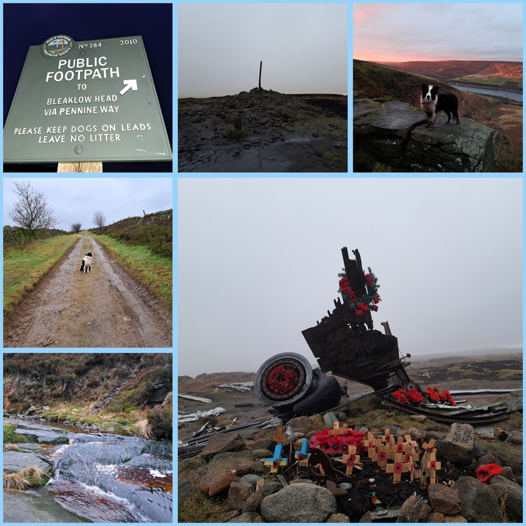
Manchester Victoria train station has a huge map on tiles. It’s part of the historic Lancashire and Yorkshire Railways station. Before split ticket applications. Before multiple rail network and ticket prices. Simpler times. A glorious end point, or a beginning, or an interchange. My Dad worked here many times. He fell off a ladder there too. Dad’s memory hasn’t been right since! Today, Friday, May 30th, a train departed at 07:21 to Leeds. Panda and I boarded it.

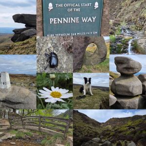
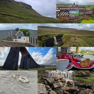
Hull Pot is surprisingly close to Horton in Ribblesdale village. A reasonable sub-hour wander up a gradual incline lined with stone makes for a decent ascent. The only difficult aspect was to turn left after around 5 minutes of leaving the B6479 (Pennine Way road) onto the Pennine Way footpath, just after Horton Beck, heading away from Brackenbottom. Head straight forward and ignore any left or right turns. Hull Pot is toward the hamlet of Foxup. Horton in Ribblesdale station has a small cafe and ample amounts of lodgings for walkers. We needed neither so trod onward and upward.

Hull Pot (91m/300′ long) is neither ceramic nor cannabis or belly. It is a quaint chasm (18m/60′ wide), opening into a gully (18m/60′ deep) of water and greenery, with thunderous cascading water pouring down a steep face of bare rock. The incredible flow of a visibly disappearing river thumped downward into a gap of glistening rock. Not the sort of place to dangle your legs unaided, yet certainly a place to watch every step. The next one may be your last. Watching Panda on a shortened lead warned me of how simple one step beyond could become fateful. Just a trip over the lead; And then a step to the right; Put your hands on your hips; and pray you don’t fall. No more Time Warp references. Sorry Richard O’Brien.

After the great view, heading as the crow flies towards the visible pathway up Pen-y-Ghent takes you away from Hull Pot‘s waterfall vista. Pen-y-Ghent, devoid of trees, shows the passage of time, weathered and individually steeply rising from a patchworked green landscape. Like Hull Pot, there are collapsed limestone features, just of rock, and streams like the one that submerges at Hull Pot only to re-emerge at Brants Gill Head. Sheep, and lambs during lambing season, are everywhere. They’re either looking for selfies or confused by Panda the border collie not trying to round them up. Today’s climb involved clouds and battering winds at the higher points, only to part for sunshine and calmness as I set off downward again. The view at the summit being somewhat shrouded by rolling clouds.

On the path downward, and barely yards from many passing feet sits another hole (Hunt Pot) in the ground. Again a waterfall slips into the broken gash of earth and a huge volume of water disappears from the ground above. Hunt Pot (60m/197′ deep) is a spot more than worthy of a good sit down, rest, and respite. Butties of radish and prawns, katsu coleslaw, and an avocado alongside a gallon of Vimto did the trick. I tucked into Ben Macintyre’s A Foreign Field, devouring a few pages as Panda rolled around in the grass. Photographs were taken of the hole and its waterfall, at which point, I decided the Ribblehead viaduct (detectable from the peak of Pen-y-Ghent) was now the walk’s targeted end point. That and the Ribblehead station, a few yards away.

Following the footpath, near parallel to the discernible flow of the River Ribble, Panda and I passed through farm fields, traversed High Birkwith, the wild flow of Coppy Gill, Brow Gill Beck, and the charming Cam Beck. Emerging onto Inman Lodge Road (B6479), turning right, the bends of Gauber Road reach Low Sleights Road (B6255) and The Station Inn (1879), at Ribblehead Viaduct. A brew, coconut cake, and a sit down were necessary. I’ve always found this area magical. It has an aura. It always calls me back. The oystercatchers, fossils, viaduct, green, and solace. My fortress of solace.

Batty Moss sits beneath the 24 spans of the Ribblehead viaduct. Modern diesel trains roll over this site and have done since the 2nd of August 1875. The picturesque bridge itself was constructed over half a decade. Over a 100 souls perished during its construction and remains of navvy camps can be found in close proximity. Thankfully smallpox, navvy brawls, and the perils of producing a 400m (440 yards) bridge are less of an issue for a rambler in 2025. The 32 metre-height (104′) may cause the odd person to stumble in awe, on a ground covered in natural potholes and squishy mosses. This sensation is often exasperated by steam locomotives crawling over the vast span of bricks and stone. After a wander seeking fossils within the bridge’s gigantic bricks, Panda and I wandered up to the old station at Ribblehead and hopped aboard a train to Leeds. Manchester Victoria was to be our final stop before home and bed. Feet up. Lovely day.

The 15 miles (24km) of walking can be found here (featuring: 2,464 ft/751m up & 2,231 ft/680m down).

Lately

The sight of the Duddon estuary around Foxfield has always tugged on my heartstrings. The rounded railway line hugs the coast and estuary like a wide horseshoe. It runs from Barrow-on-Furness to Millom and up the Cumbrian coastline. The Isle of Man lies out to sea, smothered in thick black clouds. A slight hue of pink gives a clue that sunset is somewhere towards Scotland. A crack of brilliant orange erupts along the northern horizon.

Geese honk and ducks quack as winds carry across the broad flat marshland. Occasionally trees jut out defiantly refusing to be swept away by countless vicious tides. Heather blooms in vivid yellow contrasting the slate skies of spring. Pockets of sky blue shine down on the isolated station of Green Road. A salty fragrance fills the air.

“I saw your message down the line
It gave me hope, it gave us time
So little
Time” – Doves, Strange Weather

There’s an eerie ambience to the region. As shadow on the western reaches of the Lake District. An area with less eyes upon it. The nuclear power plant at Seascale, just over twenty miles away, ensures Millom beach sees fewer visitors than other Cumbrian towns. Twenty six miles separate Whitehaven from Millom, yet little sign of tourism peers beyond the low coastal town. Hodbarrow Point lighthouse and an RSPB birding reserve gather a few feet on their travels. The remains of a windmill and a older lighthouse lurking over the headland. Remnants of another time.

Looking inland, hills dominant and mighty roll towards the many Lake District mountains. Black Combe lurks over the sleepy village of Silecroft. An algae-covered abandoned caravan shares a view back from the infrequently-visited station below. Swinside Stone Circle sits neglected to the east. Further north is Bootle. On a clear day, views from Black Combe are said to include England, Scotland, Wales, and Eire. Not bad.

RAF Millom Aviation & Military Museum parted ways with its collection and now houses His Majesty’s Prison Haverigg. Think Butlins and you’re on the right track. The jewel in the region is Ravenglass for Eskdale. Muncaster Castle and Ravenglass and Eskdale railway are delightful glimpses into the western Cumbrian life. They’re an escape from modernity into past worlds. Owls and narrow gauge steam trains. A Roman bathhouse is also worth a wander.

Wainwright’s walks may lay inland but every turn south of Seascale to Millom has something to offer. At Seascale there is also Greycroft stone circle. Less busy than the famous Stonehenge and more compact for photographers. Drigg’s dunes from Carl Crag to Kokoarrah Scar, its packhorse bridge, and clues to the WWII Royal Ordnance Factory can be found. Just ignore the Nuclear Decommissioning Authority low-level radioactive waste repository. Wasted land, indeed.

Only recently did a wander up Greenfield, near Oldham, across to the Trinnacles fill me with a warmth that is familiar. The need to share such views with loved ones is growing stronger each day. Whether at Dovestones reservoir or trudging along Cumbrian coastline, there is a hunger to live better and enjoy nature more freely. Seeing Dan, Van, Alex, and Damo made me hungry to spend time with good friends and family, as often as possible.

Kinder Scout Eggs

There’s a direct line from Brinnington to Hope. A world of differences between Ashburys and Marple. Too few similarities between Reddish North and New Mills Central. Yet the line from Manchester to Sheffield offers gems and escape. Friday the 25th of April 2025 led a path between Piccalilli train station and the quaint village of Edale.

Upstream to Grindslow Knoll, required a short wander through the village of Edale, passing the beginning of the Pennine Way. The Rambler Inn, The Nag’s Head, and Newfold Farm Cafe give a feel of what the tiny village of 400 centres around. An old and active primary school, set amongst the varied farm houses, country cottages, and Edale Parish Church show that life here isn’t all wandering. A path diverts from a truncated road over Grinds Brook. The protected stream will accompany mist walkers until Grindslow Knoll.

The paths start gentle with some undulating, before rocks, boulders, and scree start to appear intermittently. Heathers and moorland flora decorate either side of the funnelled valley. Eventually the bulk of Grinds Brook splinters into two sharp rises. Banking left involves a scramble, some choice pathway making skills, and a substantial incline. The views are increasingly dramatic. At the top, looking toward Mam Tor and Edale, much of the distance appears green and sprawling.

Following an old slabbed walkway, the journey takes explorers to a rock formation known as the Woolpacks. Peat bogs, heather, and alien-looking rocks litter, cluster, and emerge along the Kinder plateau. They mark the final wander to the peak of Kinder Scout and are a highlight for many walkers. Mermaid’s Pool, Charged Rock, and countless unnamed landmarks are worthy of an exploration.

The descent from Grindslow Knoll’s shady rear allows for farmland wanders along wide open pathways and a gentle jaunt on the home straight. Edale awaits. Edale sounds like a cake. The delicious Penny Pot Cafe banana and date oat flapjack was the only cake I had that day. Succulent. Alongside a cappuccino it made for a great reward. Before boarding the 1647 train, Panda found many a crumb landed in his fur. He promptly removed them before flopping back, head on the floor, for a nap.

Chee

A trail of stones through the River Wye was the target. The locally famous Chee Dale stepping stones have long attracted walkers to the area. Chee Dale sounds like an incomplete name. Was it Cheese Dale? Is it Witch Edale? Perhaps it never was a Dale and was Cheadle? Either way, March’s final weekend involved a fair wander that Chee Dale gorge way into the Peak District.

Sitting roughly 7 miles from Buxton, the number 65 bus bridged that gap to Miller’s Dale (53.2552720, -1.7949950) and Wormhill Road. From here a sharp left, hugging the River Wye led on a craggy pathway with soggy bits toward Chee Gorge stepping stones and links to the Monsal Trail. There’s even abseiling at bridge 75. The gorges appear after a short but rough walk, with short up and down sections permeating the steep river embankment, often sandwiched alongside treacherous hillside banking.

Chee Dale is a green oasis of babbling Wye River brooks and tributaries. Rich with birdsong and imposing limestone cliff faces, lurking with peril overhead, yet surrounded by ash woodland and flowers of vital ecological importance. In the water beneath Dippers, Willow Warblers, and various waterfowl do the bird kingdom justice. Hopeful wildlife photographers hide under canvas and perch precariously for their captures.

External content: discretion advised. May contain footage of a terrifying bird.

Having headed on t’ line at Chee Tor Tunnel, the flat pathway led back toward Buxton. Chee Tor No.1 and its sequel No.2, and the spin off Rusher Cutting led to the end of the cycle trail, where an active line prevents further passing toward Buxton. Here it meant a short wander beyond Wyedale Car Park, turning right over a footbridge. The lack of curbside or space to stand as cars rushed passed was not for the faint-hearted! Keeping Panda, my dog, close by, we stop-started our walk until safe and beyond the rushing road.

The day culminated in 12.5 miles of wandering (20km). Plenty of sideways, backwards, and around-about routes eventually led on a pathway via a short stint on the A6 to Buxton. The wide valley leading uphill from the A6 to a farm overlooking the town appeared to be an old quarry route. Plenty of places to chuck a ball for Panda safely, after his early dips in the scenic River Wye.

A blend of former railway nostalgia, nature, heritage, and peace with a climax at the spa town of Buxton, complete with spring water tap, formed a good day out which was just a short train journey from Manchester. So, where next?

Through The Leaves

Through the leaves, voices call out loud;

Beyond the tufted grasses wraps ivy thickly.

Through the greenery trees stand proud;

Along the jagged walls, bramble juts out prickly.

The murky Lancaster canal flows towards the sea;

A summer’s gentle breeze casts along its top.

Tits, swifts, and sparrow fly alongside bee;

Blackbirds hop along the mud and crop.

Feet slapping in the mud sinking slightly;

A fragrance of wild garlic hangs in the air.

Through the gaps and spaces, sun rays beam brightly;

Galloping dogs along the path they share.

Chattering and nattering creaks as trunks rub one another;

Regal flowers attract buzzing and zipping flight.

A ripple waves outwards from cygnets’ mother;

From Lancaster to Glasson Flight, a path wrapped in sights of delight.

Waterfall… & Worsley

Thursday’s wander (9.5 miles/15.5km) preceded Friday’s wandering (9 miles/15km). Both started beyond 1pm in the afternoon. Both ended as dusk passed to dark. Each walk connected to former mining sites.

Left: Thursday. Right: Friday.

Arriving at Shaw and Crompton by Metrolink, the walk led past The Morning Star public house on Grains Road. Passing The Black Ladd public house and the King’s Arms, the path once again ended up on Grains Road, by Bishops Park golf range. Turning onto a sodden mud track off Ship Lane, the aimed point of the walk entered near-sight. Here, towering over Bishops Park, a stone monument offered views to at least four counties.

Being stood at Oldham’s highest point, it didn’t take much to meander down to the source of the River Medlock. Vast quantities of water bubbled out of a gap barely bigger than a shoebox. Panda, the dog, lapped up the freshwater and hopped amongst the boggy grassland above. My boots were tested well. With that, further steps were taken.

Heading back toward The Black Ladd pub, via farm pathways and a selection of Lancashire’s finest mud. At Dog Hill Lane, the Buckstones Road led to Shore Edge Methodist Church and up a track to Brushes Clough Reservoir. A muddy yet serine picturesque place. Following the pathways around a quarry and skirting Crompton Moor, the pathway looped over Old Brook. Pingot Quarry Waterfall was the icing on a cake after a decent afternoon’s rambling. Naturally, surrounded by mud.

After a delightful waterfall came the walk back to the Metrolink stop at Shaw and Crompton. Full circle. The next day, the Metrolink start would be Eccles. The finale at the Trafford Centre Metrolink terminal. The lengthy wander through Monton passed more coffee shops than I have digits on my hands. After passing Monton Unitarian Church, it was possible to hop onto the Roe Green Loopline cycle and footpath.

The former Tyldesley Loopline railway line passes through Worsley Station. It runs almost parallel, although distancing from, to the Bridgewater Canal. The Dukes Drive green looked flooded from a saturated Folly Brook, sat beneath the raised embankments of the pathway. The pleasant path followed a straight and even course, ideal for cycling, rambling and dogwalkers alike.

At first instance of signage for Old Warke Dam, a left turn led up to a large lake underneath an old house and magical woodlands stretching up and over to Worlsey Delph. Here, like yesterday’s quarry in Crompton, evidence of mining stretched around the cold damp rocks. Worsley, as documented by the excellent Martin Zero, amongst many, is a feature-filled landscape draped in architecture and modern wonder. The Bridgwater Canal, the Alphabet Bridge, and countless old buildings spoil visitors for sights of sites. The canal pointed the remainder of the walk toward the Barton Swing Bridge at Trafford and over the Manchester Ship Canal. A stone’s throw from a place to hop on the Metrolink at the Trafford Centre.

With drier shoes than yesterday, a brew and feet up time were essential. For Panda, bacon sizzlers and some moist and meaty dog food. For Saturday, Mossley… maybe.

Healey Dell Planning

From Rochdale Town centre, passing the statue of Gracie Fields, the roads wound towards an abandoned asbestos factory, and here Panda and I skirted well wide of contaminated lands of Spotland. The so-called Spodden Valley asbestos controversy has scarred the 75-acre site. We didn’t go looking. Instead, we joined a sodden pathway along the River Spodden, heading toward Healey Dell.

Coupled with thoughts and a ball for throwing to make Panda chase, I hunkered down in the drizzling rain.I thought on how about in 2024, I must do something more human. Talk to the lonely. Comfort the desperate. Don’t be a knobhead. Think of others. Bless many, no matter their beliefs. Make the here and now matter. Improve tomorrow. Hug more. Push away negative people, paranoid eejits and fools. Surround yourself with passion, positivity, and vibes. Be kind. With the latter in mind, I threw the ball for Panda.

The river pathway crossed a road, with a higher path leading to a great viaduct, which I assume was once on the Rochdale to Bacup branch line. Passing over a rain-filled view, the bridge led to the old Whitworth station and the ruins of a stone rubbing mill. All soggy and damp. The pathway, more like a steam, carried on to the lower reaches of Whitworth village. Walking up Cown Park Way South, turning left on Tong End, the road led up to the Cown Reservoir.

This sprawling waterlogged body of a reservoir sat beneath crags and a wide valley. Up the valley, north-east, would be the source of the Spodden. At Fairies Chapel, with a cave carved by a waterfall and apparently a fill desk and writing area. The weather didn’t allow a push on to that location. Instead, a loop of the reservoir and a perusal of James Treacle Sanderson‘s memorial. The champion runner lived from 1837-1905 and appeared to be a local character of note.

James Treacle Sanderson dashed up and down the 440 yards of the Eastern shore. Panda and I squelched along as I chatted to various dogwalkers, and Panda sniffed a bottom or ten. A custard slice, a Christmas gift from Dad, made a good snack. Panda ate some dog treats, and we motored back to Rochdale in driving rains. On returning to Healey Dell, we looked at the viaduct from beneath, with Panda leaving a message for other dogs. The Healey Dell heritage centre had long closed, and daylight vanished. We headed into Rochdale Town to catch a Metrolink tram back to Manchester. A good ten and a half miles of wandering (16.8km) albeit on an afternoon of pouring rain.

Windy Hill & Blackstone Edge

Turning right from Newhey Metrolink Tram station, a short ride from Manchester, Panda, and I walked beyond Bird In Hand and The Bird In The Hand signposted public houses of Newhey. We carried on until an old stone bridge and turned left off Huddersfield Road (A640) onto a cobble path parallel to Piethorne Brook. The Brook ran behind a campsite, industrial estate, and eventually a steep cobbled road swept up over Ogden Reservoir.

Ogden Reservoir, in the Piethorne Valley, sits at the lower end of a strong of water bodies. Our path climbed west and away from the giant puddles. Crossing the Brook west of Ogden Reservoir, up some steps and beyond abandoned building foundations, the path stretched upwards towards Tunshill Lane. This battered old farm track lined with rock, split off at 53.6164428, -2.0610034. Here, the road became abandoned, waterlogged, and an ideal testing point for waterproof footwear. The odd abandoned jeep carcas lay along the way, and long lost gate posts led to nowhere in particular. After a gentle ascent, Windy Hill Transmitter sat atop a top, 389 m (1,276 ft).

Banking left from the Transmitter, the Pennine Way Bridge with splayed leg carried the Pennine Way footpath towards Blackstone Edge (1549’/472m) and whisky cave. The low cloud, fierce hailstones, and torrential precipitation tested my face for feeling and hands for the ability to withstand harsh weather. Panda bounded around joyfully despite the brutal onslaught of uncomfortable weather. The gritstone boulders make for suitable shelter in thunderous winds. The Lancashire-Yorkshire border hosts great views of Manchester, although at times, dark clouds hid the growing skyscraper-lined skyline.

The Calder, Aire, and Ryburn have origins here. Each flow east to the North Sea. Similarly, Roch and Irwell have feeder streams here, destined for the Irish Sea. Having read bits afterwards, I recommend a spot of research before rambling and looking for diverse routes to the top. There are plenty of inspirations out there. I opted for the look at a Metrolink stop and study an Ordnance Survey map for interesting features, then get out and follow a map in my head. An inspection of the weather forecast may have been wise, too. The Craghoppers rain jacket I modelled did the job, though it was touch and go!

Once you’re up, you need to take in the views, snap a few shots, or, in my case, cling to a phone camera and pray the winds didn’t rip it from my hands. The hailstone became sleet and then sideways snow. Hands numbed fast. My face felt battered. An about turn and a descent, against altitude and fading light later, and Panda and I boarded an evening tram back to Manchester. Not a bad afternoon wander. 4 hours or so, all in. So, where next?

Christmas ’23

Eight miles there. Eight back. Clayton Vale, Ashton-under-Lyne canal, the old filled in Stockport canal, and the Fallowfield Loopline cycle path paved the way from home to home. A few roads, with the odd crossing, make for a largely traffic-free route. Perfect for the Panda dog walking tight to your legs, and more importantly, good for chasing a kicked or thrown ball. A good wander.

The battle against the big C rages on. Cancer is a horrid thing. It ruins families and strikes at the centre of health, in a way crippling and doesn’t let go. As one beats it, another battles. It claims life whilst brave faces tussle and show determination to win and live go fight another day. Keep battling. You can do it.

A platter of yummy foods, traditional at Christmas, was devoured between five mouths (Panda included). Paul and Mam always know their food. The former more than the latter. Mam did her best to keep us in baked beans and curries as kids. In fact, I’d go as far as saying as Mam has always been a culinary explorer. Mam tried her best and still does to introduce me, Paul Jr. and Astrid to new forms of scran. Corn, however, is still a big no. Paul, being a former chef, knows his onions, shallots, and all the other Allium members. I feel blessed to eat well. Astrid, predisposed, wasn’t around, but hopefully, we can catch up later this week and have some competitive eating.

Christmas 2012 was the last time I ate Christmas Dinner at Mam’s before last year (2022). Those intervening years in China have dampened my mood for Christmas. With new life and youth present, it has reminded me that this special time of year is perfect for celebrating together. 2024 will be much better. I feel it. I hope for it. Christmas Dinner in 2023 consisted of a platter of potatoes, Mediterranean-style vegetables, salmon, sprouts, carrots, chicken, and gravy. It wasn’t the traditional Christmas Dinner. But, sat with Dad nattering and an episode of Last of The Summer Wine, it was pleasant enough. Merry Christmas and a happy new year.

Christmas Day involved copious amounts of dog walking, reading, and generally communicating via the mobile phone to the point of near blindness. Boxing Day would lead to more walking. 16 miles in the legs deserved a drink. The last Christmas gift opened. Belgian beer, Bernardus Abt 12, at 10% volume, sank well. Cheers, Doddsy, for the plonk. The dark quadruple was rich in flavour and suitable for watching Hunter Killer, a disappointing middle-of-the-road Russian-American conflict movie. As paint by number action movies go, it did enough to get my nose back into Flann O’Brien’s The Poor Mouth. Translated text can sometimes be difficult, but the wit and heart of the stories shine through.

Hartshead Pike Hill.

About 7.5 miles (12km) from Manchester, towering over Ashton-under-Lyne and Oldham, sits Hartshead Pike. A hill covered in history. Following Mossley Road, then a left turn onto Queens Road, before a left onto Nook Road, will allow walkers a two mile walk to the foot of the hill.

A left after The Lord Nelson pub gets you to Greenhurst Lane and a trail in the top left corner. Old cobbles and bricks line a path towards Knott Hill Reservoir. Many pathways branch away up to Hartshead Pike, and some pass the odd horse or ten. Scenery and rocky places to tuck into sandwiches are also present. The view back to Manchester isn’t bad either. On a clear day, like May the 13th, 2023, you could and can even see Welsh hills, Jodrell Bank Observatory, and Winter Hill. The whole of the Cheshire plain and huge chunks of Greater Manchester are visible.

The historic monument above Lily Lanes has been there since 1863. Before then another. And, before that possibly a Roman beacon. The hill is just 940 feet (290m) high. A walk down Lily Lanes, leads to Broadcarr Lane and eventually the picturesque town of Mossley. A fitting way to slide away by railway, back to Manchester, with Panda and mates to hand. The walk itself and return journey make it possible to visit the area within a long evening. Although, as the weather is sodden, at the time of writing, I’d take wellies and an umbrella now… and a torch, seeing as sunset is about to occur at 21:40ish…

Stanage and An Apple

Eat five fruits and vegetables a day. That used to be the message from health-promoting government officials. Now there’s a message doing the rounds: limit your purchases of cucumbers and tomatoes. Great Britain is experiencing a shortage of fruit and vegetables. Europe is not, on the whole, struggling for green foods. The labour shortages on farms in the U.K. experienced since Britain exited the European Union, are being mirrored by asylum-seeking boat crews and filled seats. Unemployment rates in the U.K. remain high. Jackets and aid packages are being gathered and sent to earthquake-torn Syria and Turkey, whilst homelessness in the UK spirals into greater numbers. The U.K.’s economy is fragilestrike action is booming, and somewhere Shell, BPTescoRio TintoLegal & GeneralUnilever, HSBC Holdings, Vodafone, GlaxoSmithKilen etc are all doing really well. With the world being really stable, Shaun, Christina, Panda and I went for a wander.

The train journey duration from Manchester to the historic two platforms of Grindleford lasted just under an hour. Opened in 1894, the station bridged the lower reaches of Burbage Brook. The station close to Sheffield is just next to the 3.5-mile long (5.7km) Totley tunnel. Our path led from the toilet in the café, up the picturesque upper tributary stream. After a few hundred metres or yards (if you choose), we crossed a wooden bridge and ascended a pathway to a higher level. The deep narrow gauge of Padley Brook is completed by trees, mosses, and steep drops. All were avoided, thankfully. The rich, clean air, a welcome greeting, has left the air of Manchester behind. The temperate rainforest along this route are apparently the furthest inland of their kind, in Britain. Our route led uphill, with relatively unchallenging steps and climbs here or there.

At White Path Moss, a little further north of Toad’s Mouth, the moorland drains and forms the source of Burbage Brook. The gently flowing stream starts somewhere near Stanage Edge. On our walk we didn’t spot any water voles, but we did hear a variety of birdlife including the hawfinch and wood warbler. Nature perfectly cuts into the bleak moorland and offers veins of life amongst the scattered glacial stones and boulders. Dry wintery grasses jutted out from soggy soil and bogs. Walking boots were a cosy necessity.

Soon after crossing a road, stretching over the Burbage Brook once more, and ascending a slope we arrived at Carl Wark (370m/1214ft high). This rocky promontory juts out and on it are the remains of an Iron Age fort. The view from Higgor Tor (434m/1424ft) back to Carl Wark is impressive. You can really see Carl Wark as an island sat atop the sea of the moor. After scrambling through Higgor Tor, we moved onto the Stanage Edge (Stanage means ‘stone edge’). So we were on the edge of the stone’s edge. Popular with climbers, abseiling enthusiasts, walkers and artistic types we meandered a fair distance down the crinkly fragile crust prominence. We explored Robin Hood’s Cave and also crossed the Long Causeway down to Hathersage village for the train back. The famous crags and Panda, loose from his lead at times, make for heart-in-the-mouth opportunities. Luckily a well-behaved and heavier supervised dog could not be found. Panda behaved well when passing by St Michael’s Church and didn’t dig up the remains of the legendary 2.46m (8ft) Little John (Robin Hood’s buddy).

As we boarded the train, all shattered and hungry, I read about the Fat Boys Stanage Struggle and vowed to myself never to enter. The accent from Hathersage (91m/299ft) upwards is firmly not on my bucket list. More likely, a viewing of Pride & Prejudice filmed at parts of Stanage Edge. Perhaps, in the near future, we can wander up there again. The 13.5-mile (22km) route was most enjoyable in good company.

Over Exposed.

The train from Manchester to Glossop was ideal and on time. Unlike yesterday, I didn’t end up in Hadfield. Having slept well, with the owls of Newton Heath’s Clayton Vale sounding their calls, I felt refreshed for a morning and headed off with the energy of my trusty dog Panda. Rounding the town of Glossop, the Derbyshire Levels road led onto a pathway up into the hills and moors.

The first major hurdle was squelchy and muddy but largely passable, especially once Panda and I found the footpath. The footpath, largely lined with flat stone slabs, passed in a meandering pattern towards Snake’s Pass Summit. The largely quiet A57 connects Manchester to Sheffield, ensuring Owls fans can watch SWFC when they face Manchester City again. The Thomas Telford designed road hits 1,680 feet (510m) at its highest point – the point where Panda and I crossed onto Bleaklow.

Having traversed Kinder Scout’s surrounding moorland at Featherbed Top, the walk through Devil’s Dike seemed to do the impossible. How it could have got wetter, heaven knows. Views back towards Cheshire, Snowdonia in the far sunlight and Manchester were the only reminders that Earth isn’t entirely soggy. Groughs of mosses (Sphagnum), heathers, and moorland species seemed drenched. The pathway lay submerged at times. Hares bounded around, splashing, whilst grouse landed with plops. Navigating to get back on the pathway over Featherbed Top was difficult.

The pathway through Devil’s Dike was more like a stream. The stream and path sat side by side. Sometimes on top. Often below. The two had become intertwined in a kind of natural Kama Sutra. The pathway panned out and eventually reached the 2,077 feet summit (633m). First of all, wreckage from the reconnaissance USAF aircraft, Boeing RB-29A Superfortress 44-61999 (named: Over Exposed), scattered over a huge patch. The remains featured a memorial patch. This eerie spectre sat atop an area of mud and tuft-shaped groughs.

Flying over a hill in low clouds takes guts. Sadly, some pilots and their navigation crew have succumbed to nature’s will. These wicked Dark Peak and Pennine hills have claimed many lives from World War II to the present day. Looking at the Peak District Air Crashes website, it’s instantly apparent that night or day clouds are lethal barriers. The descending path from Bleaklow to Torside had several more crash sites, including a Bristol Blenheim and Lancaster Bomber parts.

The pathway from Bleaklow to Torside went from the high Hewitt (Hills in England, Wales, and Ireland over two thousand) to the edges of the Torside reservoir’s neighbouring farms (by B6105 Crowden to Glossop road) . The 453rd highest Hewitt features more than enough featureless boggy crags to last you a lifetime. Plenty of broken walls, paths and steep drops await the rambler as they descend or ascend the soaked landscape. A word to the wise: wear waterproofs and tough boots. Views of Black Hill and Holme Moss, amongst others greet you. The ground, with plenty of sinking points, also comforts you on the inevitable fall. Wainwright called it an “inhospitable wilderness” and I’d call parts of the trail an abomination on the feet.

Glossop train station to Bleaklow is about 7.5 miles (12km). Bleaklow to Torside is 3.3 miles (5.3km). Torside to Royston Vasey (Hadfield) is about 3 miles (4.8km). Not surprisingly, today’s walk totalled over 44000 steps. 13.8 miles (22.1km) was the minimum distance covered. In reality, it was closer to 18 miles (28.9km) all in. Definitely, longer than yesterday. Next, sore feet and a lazy Tuesday. Also, it will be time to reflect on the mountain hares spotted at a distance. A great pleasure, indeed. Unlike Alfred Wainwright, who said of Bleaklow, “All who get on it, are glad to get off,” I fancy a return soon. It was a great but arguably an arduous walk.

The Long Longdendale Trail

The Longdendale Trail is 6.5 miles (10.5km) long. To walk from the beginning and back again is about 13 miles (21km). Add a waterfall trail near the sealed former railway Woodhead Tunnel entrances, and you’ve easily hit 16 miles (25.7km). Factor in prawn sandwiches, a brief sit down to feed Panda, and the best part of 11am to 6.15pm will evaporate. Just add 38000 steps.

The day’s walk began at Hadfield Station, which was weird because I was supposed to be getting off the train at Glossop. It seemed silly to wait for another train, so Panda and I set off at pace. The low gradient path rises and is ideal for cycling, horses, or dogwalking like what we were doing. The trail is part of the Hull to Liverpool Trans Pennine Trail, or national cycle route 62. Several reservoirs line the lower side, and the upper crags, swamps, and Bleakmoor.

You could even use the route as part of Cork (Ireland) to Istanbul (Turkey). The E8 European long-distance path runs past the River Etherow and the picturesque Derbyshire town of Hadfield. Hadfield, like Glossop, is about 40 minutes by train from Manchester Piccadilly. This High Peak Town sits over Bottoms Lake. That man-made reservoir forms part of the Longdendale Chain. The most upper reservoir is Woodhead Reservoir. Since around 1884, millions of gallons of water have been captured and sent to Manchester and Salford as Corporation Pop (drinking water).

Our walk also passed Arnfield, Valehouse, Rhodeswood and Torside Reservoirs. Hollingworth Reservoir has been reclaimed as a woodland. Like the woodland, the whole of the Longdendale valley is scenic and green. Tintwistle and a selection of hamlets make for great places to admire the views. UFOs and strange lights have been noted. The closest we came to this were a few deer on the dusky walk back. That and headlights over the valley on the Woodhead Pass (A628) as the walk reached the final act. Panda earned his ham on the bone treat. I’ll have Coco Pops.

The treat at the far end from Hadfield was a wander up Middle Black Clough to a spread of waterfalls and steep green vales. The walk alone was great. The extra trail at the end was excellent. It was a real challenge for the four legs of Panda and an opportunity to do some rock-scrambling. All in all, it was a lovely day out. So, where next?