Fifth tallest heap of stones.
A rocky outcrop summit.
Scramble hard. Scramble long.
A new height:
views abound.
Drystone walls and paths of gold.
Fifth tallest heap of stones.
A rocky outcrop summit.
Scramble hard. Scramble long.
A new height:
views abound.
Drystone walls and paths of gold.
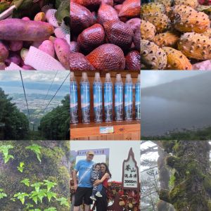
Dali Lannatai Coffee Cute Pet Hotel [大理兰纳泰式咖啡萌宠美宿] located on人民路下段东玉街51号 has a rather girthy name. Coffee and pets. What more do you need?! Turned out to be such a cosy place that we stayed twice – and even extended the second stay for a few nights. It did help that our Mancunian Panda teddy was left behind on the first stay. A rescue mission return was required.
A steep cable car up Cangshan took us close to the highest summit. At the top end, Ganton ropeway has paths leading to a lake view at Ximatan (3920m up) and many, many stairs. The cloud cover, damp, thinner air, and gentle breezy movement made walking a tad slippy but doable. Dali-Cangshan UNESCO Global Geopark is gorgeous but treacherous at parts. Steep rocks, sudden drops, and streams slice through the vast landscape offering ample opportunities to test gravity.
The ancient old town of Dali dispersed with its modernity amongst many nooks and crannies is quaint and wild. Party life sits alongside the classic. It feels freer than most Chinese cities and towns. It howls and it barks. Yet, with hotels that have star-gazing rooftops and hidden parks with orange-bellied Hiamalyan squirrels chewing on dropped nuts, the old and new work well together. Its cosmopolitan heartbeat is loud and quiet at the same time. There’s adventure outside the walls and discovery within. Cafes, artists, independent dealers of novel fashion, and mass-produced and much-copied formulas work for space. This synergy is harmony in action. Yet, even having visited in 2021, I could sense that in 2025, the growth and change of Dali was unsustainable and yet another characterless city will emerge. I hope I am wrong!
The amount of disposable oxygen canisters for sale on the ropeway concourse and single-use rain jackets, hoods, hats and more is worrying. Yes, oxygen may be needed but surely adapting and slowing your wandering is much more sensible. Altitude is not to be played with and rising a kilometre in Yunnan can be fatal if rushed. Any dizziness, lightheaded feelings etc can be alarm bells. Take it at a more gentle pace and don’t race to the top. Or not: just buy oxygen canisters.
I can understand hiring big waterproof rain and winter jackets but far too much has been geared for waste. Nature needs harmony and help. The litter levels were low on the pathways at the top but it was clear that far too many people ignore waste bins. This is a global problem. Not just China. Not just Manchester. Scenic streams and lakes need that crispness and freshness that only Mother Nature can bring. We must reconnect to the air, water, and plants that bring us so much comfort and essential conditioning for life. With that the air around Dali and Cangshan is lush and comfortable. Next, Shangri-la calls once again.
Yunnan, of course, was great for fruits. The fertile soils and close proximity of Vietnam and other nations (for swift importing) gave numerous chances to try new fruits. Nothing stood out. Apart from local blueberries and raspberries. The sharp Salak or snake fruit wasn’t that tasty. Nor a fruit that looked like a purple banana. God bless the Silk Road.
The train from Manchester to Glossop was ideal and on time. Unlike yesterday, I didn’t end up in Hadfield. Having slept well, with the owls of Newton Heath’s Clayton Vale sounding their calls, I felt refreshed for a morning and headed off with the energy of my trusty dog Panda. Rounding the town of Glossop, the Derbyshire Levels road led onto a pathway up into the hills and moors.
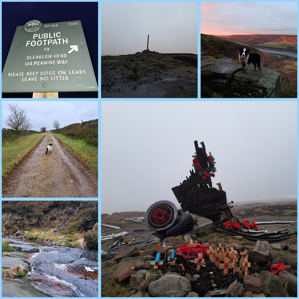
The first major hurdle was squelchy and muddy but largely passable, especially once Panda and I found the footpath. The footpath, largely lined with flat stone slabs, passed in a meandering pattern towards Snake’s Pass Summit. The largely quiet A57 connects Manchester to Sheffield, ensuring Owls fans can watch SWFC when they face Manchester City again. The Thomas Telford designed road hits 1,680 feet (510m) at its highest point – the point where Panda and I crossed onto Bleaklow.
Having traversed Kinder Scout’s surrounding moorland at Featherbed Top, the walk through Devil’s Dike seemed to do the impossible. How it could have got wetter, heaven knows. Views back towards Cheshire, Snowdonia in the far sunlight and Manchester were the only reminders that Earth isn’t entirely soggy. Groughs of mosses (Sphagnum), heathers, and moorland species seemed drenched. The pathway lay submerged at times. Hares bounded around, splashing, whilst grouse landed with plops. Navigating to get back on the pathway over Featherbed Top was difficult.
The pathway through Devil’s Dike was more like a stream. The stream and path sat side by side. Sometimes on top. Often below. The two had become intertwined in a kind of natural Kama Sutra. The pathway panned out and eventually reached the 2,077 feet summit (633m). First of all, wreckage from the reconnaissance USAF aircraft, Boeing RB-29A Superfortress 44-61999 (named: Over Exposed), scattered over a huge patch. The remains featured a memorial patch. This eerie spectre sat atop an area of mud and tuft-shaped groughs.
Flying over a hill in low clouds takes guts. Sadly, some pilots and their navigation crew have succumbed to nature’s will. These wicked Dark Peak and Pennine hills have claimed many lives from World War II to the present day. Looking at the Peak District Air Crashes website, it’s instantly apparent that night or day clouds are lethal barriers. The descending path from Bleaklow to Torside had several more crash sites, including a Bristol Blenheim and Lancaster Bomber parts.
The pathway from Bleaklow to Torside went from the high Hewitt (Hills in England, Wales, and Ireland over two thousand) to the edges of the Torside reservoir’s neighbouring farms (by B6105 Crowden to Glossop road) . The 453rd highest Hewitt features more than enough featureless boggy crags to last you a lifetime. Plenty of broken walls, paths and steep drops await the rambler as they descend or ascend the soaked landscape. A word to the wise: wear waterproofs and tough boots. Views of Black Hill and Holme Moss, amongst others greet you. The ground, with plenty of sinking points, also comforts you on the inevitable fall. Wainwright called it an “inhospitable wilderness” and I’d call parts of the trail an abomination on the feet.
Glossop train station to Bleaklow is about 7.5 miles (12km). Bleaklow to Torside is 3.3 miles (5.3km). Torside to Royston Vasey (Hadfield) is about 3 miles (4.8km). Not surprisingly, today’s walk totalled over 44000 steps. 13.8 miles (22.1km) was the minimum distance covered. In reality, it was closer to 18 miles (28.9km) all in. Definitely, longer than yesterday. Next, sore feet and a lazy Tuesday. Also, it will be time to reflect on the mountain hares spotted at a distance. A great pleasure, indeed. Unlike Alfred Wainwright, who said of Bleaklow, “All who get on it, are glad to get off,” I fancy a return soon. It was a great but arguably an arduous walk.
How do!
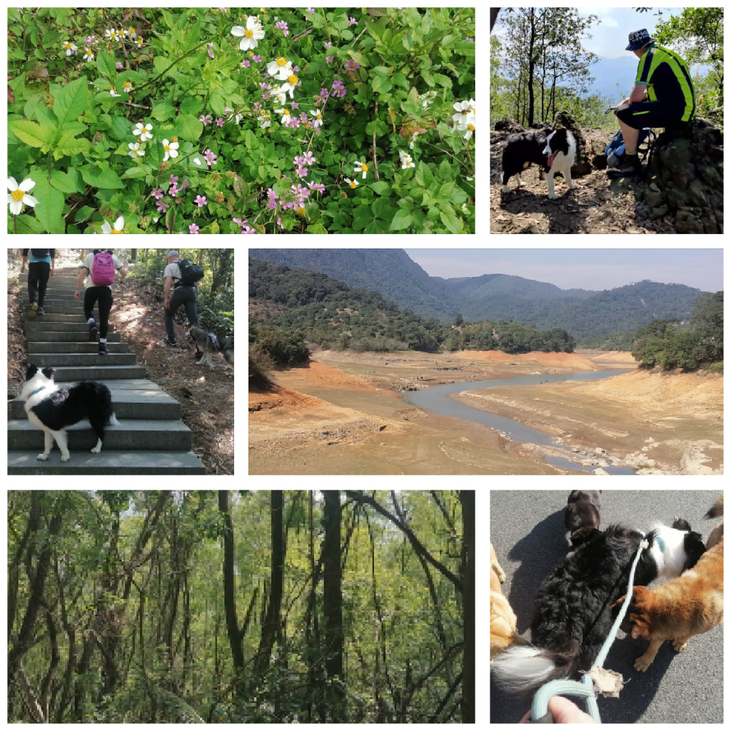
Today’s plan C ended up at 崖山古 (Yáshāngǔjì, cliff mountain historical place). It wasn’t meant to be this way. Moiz, Aaron, Matt and I, alongside two dogs had a roundabout wander.
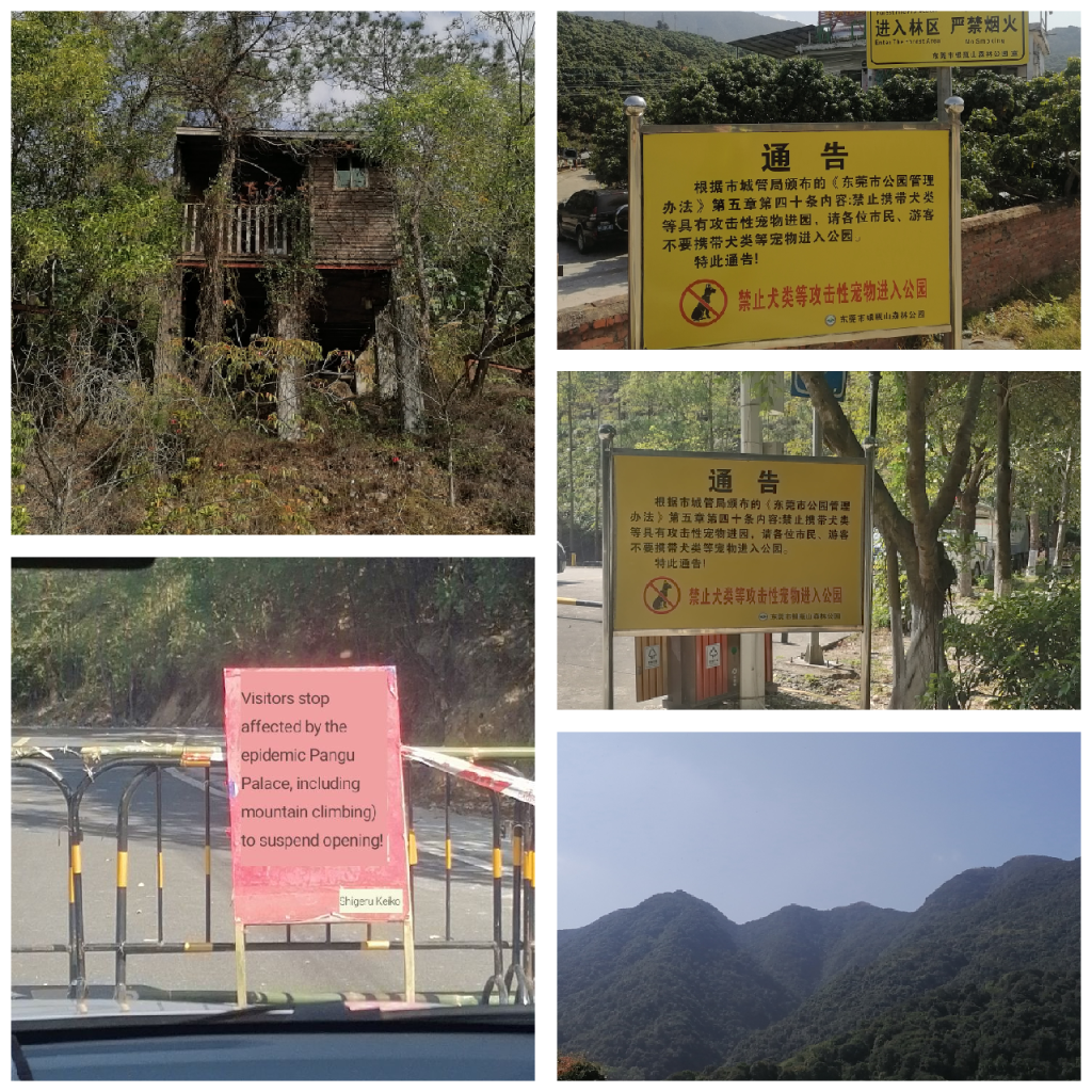
The Yashan mountain monuments are located north of the Li Village of Xiegang, a town in Dongguan City. The approach is made up of abandoned theme village with hollow lodges and skeletal outdoor structures, which suits the tombstone-lined face of the short hillock. A round trek loop of around 6km is possible, assuming you brave the ridges and scree slopes surrounding a small pagoda at the top. It’s ideal for walking a dog. Panda and Matt’s dog certainly enjoyed it.
Tan Xian Temple (Ming Dynasty, 1882) was rebuilt in 2001. It’s brick and concrete isn’t so appealing for tourism, despite the green mountain location. The site has been protected by the Dongguan government, however, due to the cultural value of a poem inscription and something about a waterfall. We didn’t find a waterfall. The eastern flank of the hillock unfolds to a large dry quarry. Not exactly the lush wetness of a waterfall.
Plan A had been BaiYunZhang (白云嶂) over at the edge of Huizhou (惠州) and Dongguan. On arrival by Didi car we found the road by the Pangu Temple (新圩约场白云嶂盘古庙) we found a barrier and two guards. Also, a half dozen dogs. The sign translation shown as something akin to “YOU SHALL NOT PASS!” There was no pleading with the guards. Something about a virus case had closed the temple and all hiking routes.
Plan B was equally disappointing. Yingpingshan in Dongguan is the tallest mountain and part of a huge nature reserve. No dogs allowed. Not even if you pick up their turds. No well-behaved dogs. Go away dogs. So, after a stroll around a lower reservoir, Aaron and Matt located a small hillock for us to explore. Plan C, in the recently arrived 20°C temperature, wasn’t the worst way to end a second Tiger year trek. Better than house arrest, for example.
That’s all folks! Ta’ra!
Do you recall Kim? Before her Evangelia. Wasn’t there a Jayne too? Nikki wasn’t too quickly. Shirley not? Wendy house? Didn’t you once meet unrequited love? You said you wouldn’t carry on or try again. But, you did! And, who now? Who do you fancy? Is it that Nancy? Or Daisy who drives you crazy? Or Spring, Summer or Autumn? The seasons of choice? Dance with your dreams.
Do you remember that Karst mountain? It rise from the ground like a camel’s hump. You said to yourself it was the most beautiful mountain you’d ever seen. And then you set eyes on Everest. Then Ama Dablam. Then Annapurna one, two and three. Fishtail Mountain. Snowden again and again. Always Winter Hill, but forever dreams of new peaks unseen.
You said you wouldn’t read after Jon Ronson. Wasn’t Jurassic Park the book to end all books? Then Airframe, the Animals of Farthing Wood should. The Jack Reacher series could. Ian Fleming gave you the spy that ended all spies. Pages of love, lies and cries. Yet, you close your eyes and there’s no disguise. Your bookmark never hides.
Back in the day wasn’t Ghostbusters always your favourite? Gremlins and Goonies, two you’d never forget. Watching Jaws, again, without regret! 007 live and let. Leslie Neilson going on and on, I bet. Movies like Gemini Man and iRobot to watch once – no fret. The minds eye full of Skynet.
Things are said one day. Things come and go away. With each passing birthday I say, never betray your display of child’s play. Each day we find a way to convey the driveway of life. Hooray! The outlay does not outweigh what we repay on our stairway to our breakaway. Fly like a bird of prey.
Written in January 2020, in Nepal, on a notepad. Before COVID-19 became annoying.
Tashi Delek / 你好 / Hey, hey!
It was Christmas Eve and I enjoyed scrambled eggs, with toast and cappuccino. I decided to have an easy day of wandering. To acclimatize to altitude is important. I drank ginger tea, water and ate bananas with other dried fruits. Other tricks include walking high and then sleeping low. So, for Christmas Eve, I looked for a bumpy mountain. I had my eye on a few peaks around this valley that envelopes Shangri La city. The cold was manageable with a City shirt and my trusted Sherpa jacket. The Italian wool socks were and are highly effective too. Nighttime hit -12C outside but inside a Green Tree Hotel it was standard room temperature.
Following a late breakfast at The Compass, I headed to LánYuèGǔ (蓝月谷) which translates to Blue Moon Valley. It’s real name is Shika Mountain (石卡山; Shíkǎshān) and it towers to the west above Diqing Shangri-La Airport (DIG). The airport is at at around 3280m. I was able to wander up to about 3500m, way shy of the peak towering above. There were too many people saying, “You shall not pass.” Strong winds had closed the nearby cable car and every path upwards. Rules is rules. I headed back and spotted some cranes, a photo opportunity or two and plenty of construction. Some splendid stupas and magnificent views made for a pleasant wander. Blue Moon wasn’t all that, but the name belongs to City’s chant so what’d you expect?
In the evening, I enjoyed local Tibetan food and hospitality before heading back to rest. I woke up in the same Green Tree hotel, opposite the city bus station. At 08:20, I was on a bus headed for Déqīn town or city. Unsure what it actually is. From there many trails lead off to waterfalls, glaciers and villages. This area is spelled as Diqen, Díqìng and Deqin (བདེ་ཆེན་རྫོང་). It’s rather confusing. Since Tibet handed over Kham province to Yunnan province, it’s become autonomous (迪庆藏族自治州). The many names should be a starting point for a clear up. By noon, after a climbing route of a road trip, the bus pulled into Deqing city’s bus station. Here I was told that I could go onto Feilaisi (飞来寺) village. I agreed and returned after a quick lunch. Less than an hour later and the bus halted outside a terrace of hotels. Opposite stood a rather imposing two metre wall. Beyond that wall, a view to a kill. The picturesque and snow capped range of MeiLi Snow Mountain (梅里雪山).
After a few minutes standing outside I checked into the a catching named hotel, Deqin Snow Mountain Town Tourist Reception Center (No.2 Reception). I couldn’t find the sequel. After dropping my bag up four flights of stairs, I grabbed my camera and crossed the road into the Mingzhu Langka Viewing Platform, and following my health code check, I was away to wander and enjoy the view. The panoramic settings on cameras was made especially for this kind of scene. The clear air, beautiful blue skies and Lancang river valley below only added to the dramatic setting. A main deck with 8 stupas, a rare Mani wall, and an abundance of prayer flags made my Christmas Day special in ways I hadn’t previously imagined.

The fluttering sound of prayer flags, slapping each other, and spiraling up and down on winds with the fragrance of incense and juniper took me moments to clear my mind. The overwhelming scenery had swallowed me up. With each majestic cloud hovering like a pirouette over the many peaks, it was easy to catch my jaw falling lower than usual. The interjection ‘wow’ felt seriously below par, yet it flew out of my mouth with consummate ease. The main peak, Kawagarbo, is 6740m up. Tibetan people refer to it as Nyainqênkawagarbo. It’s a hugely sacred mountain and climbing is banned. Climbers have tried and in 1991 it claimed 17 members of one expedition. It is a sinister and magnificent looking mountain range with twenty peaks, of those 6 tower over 6000m. Tibetan pilgrims cover a different distance each year, circumambulating 240km (150 miles) around the mountain base, praying to the warrior God inside the mountain. This UNESCO World Heritage Site has a real spiritual ambience. I’d look upon the framed snow peaks on both Christmas Day and Boxing Day in wonder. Absolutely stunning.
On Boxing Day, my light stroll rewarded me with views of at least ten vultures and different angles of the mountains over the raging river below. Dinner was nothing to shout home about but the oranges and pomegranates around Feilaisi certainly need a positive mention.
The walk goes on…
Greetings from Dalingshan, Dongguan, P. R. C.
I slept too much. Having showered around 6pm this evening, I lay on the bed drying in a towel. I woke up by 11pm. A glass of grapefruit juice and a bowl of honey nut loops followed. The crisp cold milk gave me a breakfast feel, despite no sunlight finding my balcony. I slowly awoke and reflected over a simple weekend.
For a few hours today, my Australian colleague, Mr Oliver and I walked up Lotus Mountain in Chang’an town. We descended towards Dalingshan. It was a pleasant walk but the questionable air quality and lack of visibility outside of the grey spectrum made it less impressive. Numerous people covered their mouths as two foreigners strode on by. The insulting behaviours have been less of late, but today it happened often enough to feel deliberate and perplexing. On the flip side, enough men cleared their throat whilst staring into my face, enough for me to remember this unusual yet familiar passing greeting. I still wonder if they clear their nose and throat out when they pass others, or even alone. If a tree falls in a forest and nobody is around to hear it, did it make a sound?
Today’s sweaty walk was riddled with steps. Yesterday’s activities involved an exchange of the B. Twin Rock rider 520ST for a Merida Challenger mountain bike. A need for a larger frame necessitated such a move. Plus the Decathlon bicycle seems cursed. Three punctures, two collisions and a creaky seat later, I feel 8 months of regret about this cycle needs to be resolved. Those who resolve conflict, seek solace.
A class with Tina, and a good salad made with heart yesterday were highlights amongst a day filled with BBC’s McMafia TV series and very little else. The autumn grey skies are here. It feels cooler but also warm at times. My mind is muggy and in need of something more. The mountains are calling.
Time to sleep. Peace and love x
