The train from Manchester to Glossop was ideal and on time. Unlike yesterday, I didn’t end up in Hadfield. Having slept well, with the owls of Newton Heath’s Clayton Vale sounding their calls, I felt refreshed for a morning and headed off with the energy of my trusty dog Panda. Rounding the town of Glossop, the Derbyshire Levels road led onto a pathway up into the hills and moors.
The first major hurdle was squelchy and muddy but largely passable, especially once Panda and I found the footpath. The footpath, largely lined with flat stone slabs, passed in a meandering pattern towards Snake’s Pass Summit. The largely quiet A57 connects Manchester to Sheffield, ensuring Owls fans can watch SWFC when they face Manchester City again. The Thomas Telford designed road hits 1,680 feet (510m) at its highest point – the point where Panda and I crossed onto Bleaklow.
Having traversed Kinder Scout’s surrounding moorland at Featherbed Top, the walk through Devil’s Dike seemed to do the impossible. How it could have got wetter, heaven knows. Views back towards Cheshire, Snowdonia in the far sunlight and Manchester were the only reminders that Earth isn’t entirely soggy. Groughs of mosses (Sphagnum), heathers, and moorland species seemed drenched. The pathway lay submerged at times. Hares bounded around, splashing, whilst grouse landed with plops. Navigating to get back on the pathway over Featherbed Top was difficult.
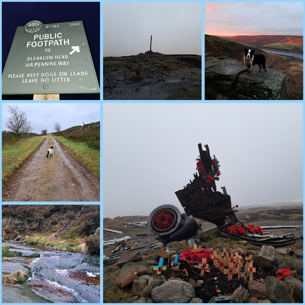
The pathway through Devil’s Dike was more like a stream. The stream and path sat side by side. Sometimes on top. Often below. The two had become intertwined in a kind of natural Kama Sutra. The pathway panned out and eventually reached the 2,077 feet summit (633m). First of all, wreckage from the reconnaissance USAF aircraft, Boeing RB-29A Superfortress 44-61999 (named: Over Exposed), scattered over a huge patch. The remains featured a memorial patch. This eerie spectre sat atop an area of mud and tuft-shaped groughs.
Flying over a hill in low clouds takes guts. Sadly, some pilots and their navigation crew have succumbed to nature’s will. These wicked Dark Peak and Pennine hills have claimed many lives from World War II to the present day. Looking at the Peak District Air Crashes website, it’s instantly apparent that night or day clouds are lethal barriers. The descending path from Bleaklow to Torside had several more crash sites, including a Bristol Blenheim and Lancaster Bomber parts.
The pathway from Bleaklow to Torside went from the high Hewitt (Hills in England, Wales, and Ireland over two thousand) to the edges of the Torside reservoir’s neighbouring farms (by B6105 Crowden to Glossop road) . The 453rd highest Hewitt features more than enough featureless boggy crags to last you a lifetime. Plenty of broken walls, paths and steep drops await the rambler as they descend or ascend the soaked landscape. A word to the wise: wear waterproofs and tough boots. Views of Black Hill and Holme Moss, amongst others greet you. The ground, with plenty of sinking points, also comforts you on the inevitable fall. Wainwright called it an “inhospitable wilderness” and I’d call parts of the trail an abomination on the feet.
Glossop train station to Bleaklow is about 7.5 miles (12km). Bleaklow to Torside is 3.3 miles (5.3km). Torside to Royston Vasey (Hadfield) is about 3 miles (4.8km). Not surprisingly, today’s walk totalled over 44000 steps. 13.8 miles (22.1km) was the minimum distance covered. In reality, it was closer to 18 miles (28.9km) all in. Definitely, longer than yesterday. Next, sore feet and a lazy Tuesday. Also, it will be time to reflect on the mountain hares spotted at a distance. A great pleasure, indeed. Unlike Alfred Wainwright, who said of Bleaklow, “All who get on it, are glad to get off,” I fancy a return soon. It was a great but arguably an arduous walk.

