Summer ’25: VI – Shangri-la III

The slow ride on the altitude-gaining train involved various stops. Passing loops. Halts. Two stations. Sales pitches along the railway carriage. Glorious views sandwiched by lengthy tunnels. More tunnels. A relaxed pace ride through even more tunnels. The usual high speed of China’s modern rail network suddenly felt more sedate. The 304km (189 miles) Dali to Shangri-la train ride didn’t whiz by, but the views between the tunnels were nonetheless fascinating. 4 hours and 19 minutes later, we arrived. My third time to purposefully visit Shangrila.

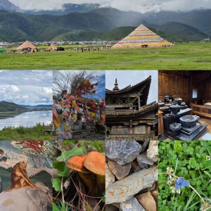
Departing straight into a local taxi (Didi滴滴) the flats of Xiānggélǐlā 香格里拉 spread out. A wide valley of farmland amongst mountains and foothills. Picturesque didn’t fit the description well enough. Cattle crossed the narrow road. Horses in lines moved with passengers on their backs. Many visitors wore Tibetan attire for photographs. Vast colourful prayer pyramids rose from the ground. Much was geared for photographers and travellers. Between the lines, the real Tibetan vibes and cultures intertwined a rapidly growing western front of China.

3km to the west of the railway station, a lodging was booked. The Lodge, Shangri-la Lao Shay Youth Hostel [香格里拉老谢车马店] is a dated yet cosy wooden lodge of three floors on the Napahai grasslands of Xiānggélǐlā at [石卡雪山纳帕海景区石卡路吉奴古村]. The sharp roof, underlay by two floors with fully-covered balconies, and timber towered over a small open courtyard. A secondary building, like a letter-L, stood to its left, housing an internal courtyard. The hotel’s names stretched across the side. A small faded sign erected at the roadside broke up a field of emptiness. In Tibetan the name looks better [སེམས་ཀྱི་ཉི་ཟླ།]. The barley wooden frames scattered by roadside and along the grasslands

A trip to the Shangri-La Alpine Botanical Garden (香格里拉高山植物园) didn’t disappoint. Seeing wild hares, a plethora of birds and insects, and countless plants filled the majority of an afternoon. The high-altitude 7,247 hectare garden of flora overlooked the expansive Napa lake below. The world first low and high altitude garden happens to be the Tibetan plain’s sole dedicated botanical garden. 30RMB well spent. We exited the park at 1830, slightly after the 1700 closing time. On returning, we walked to Gongbi Village Stop (贡比村站) and admired the drones flying iver the farmland spraying whatever it is on whatever was growing. Over the road the traditional hand methods tended to wheat fields.

Later, I’d research the longest tunnels and be shocked that a ten mile long tunnel we’d passed through didn’t even make China’s top 395 railway tunnels! The engineers of China have built incredible spans of bridges and underground tunnels, making it hard for you to comprehend or imagine the scale of the great nation of China. Its lands are 9.57 million km² (3.7 million miles). All of the land of Europe is 10.53 million km² (3.933 million miles²). And bigger than the USA. Only Russia (almost double) and Canada (by a smidgeon) are greater in size. Travelling in China really shows you how far and how diverse the landscape is, even if cities and towns take on a copy and paste feel. You’re never more than a mile from a Luckin Coffee (China’s equivalent to Starbucks or Costa Coffee). Other coffee shops are available.

Over Exposed.

The train from Manchester to Glossop was ideal and on time. Unlike yesterday, I didn’t end up in Hadfield. Having slept well, with the owls of Newton Heath’s Clayton Vale sounding their calls, I felt refreshed for a morning and headed off with the energy of my trusty dog Panda. Rounding the town of Glossop, the Derbyshire Levels road led onto a pathway up into the hills and moors.

The first major hurdle was squelchy and muddy but largely passable, especially once Panda and I found the footpath. The footpath, largely lined with flat stone slabs, passed in a meandering pattern towards Snake’s Pass Summit. The largely quiet A57 connects Manchester to Sheffield, ensuring Owls fans can watch SWFC when they face Manchester City again. The Thomas Telford designed road hits 1,680 feet (510m) at its highest point – the point where Panda and I crossed onto Bleaklow.

Having traversed Kinder Scout’s surrounding moorland at Featherbed Top, the walk through Devil’s Dike seemed to do the impossible. How it could have got wetter, heaven knows. Views back towards Cheshire, Snowdonia in the far sunlight and Manchester were the only reminders that Earth isn’t entirely soggy. Groughs of mosses (Sphagnum), heathers, and moorland species seemed drenched. The pathway lay submerged at times. Hares bounded around, splashing, whilst grouse landed with plops. Navigating to get back on the pathway over Featherbed Top was difficult.

The pathway through Devil’s Dike was more like a stream. The stream and path sat side by side. Sometimes on top. Often below. The two had become intertwined in a kind of natural Kama Sutra. The pathway panned out and eventually reached the 2,077 feet summit (633m). First of all, wreckage from the reconnaissance USAF aircraft, Boeing RB-29A Superfortress 44-61999 (named: Over Exposed), scattered over a huge patch. The remains featured a memorial patch. This eerie spectre sat atop an area of mud and tuft-shaped groughs.

Flying over a hill in low clouds takes guts. Sadly, some pilots and their navigation crew have succumbed to nature’s will. These wicked Dark Peak and Pennine hills have claimed many lives from World War II to the present day. Looking at the Peak District Air Crashes website, it’s instantly apparent that night or day clouds are lethal barriers. The descending path from Bleaklow to Torside had several more crash sites, including a Bristol Blenheim and Lancaster Bomber parts.

The pathway from Bleaklow to Torside went from the high Hewitt (Hills in England, Wales, and Ireland over two thousand) to the edges of the Torside reservoir’s neighbouring farms (by B6105 Crowden to Glossop road) . The 453rd highest Hewitt features more than enough featureless boggy crags to last you a lifetime. Plenty of broken walls, paths and steep drops await the rambler as they descend or ascend the soaked landscape. A word to the wise: wear waterproofs and tough boots. Views of Black Hill and Holme Moss, amongst others greet you. The ground, with plenty of sinking points, also comforts you on the inevitable fall. Wainwright called it an “inhospitable wilderness” and I’d call parts of the trail an abomination on the feet.

Glossop train station to Bleaklow is about 7.5 miles (12km). Bleaklow to Torside is 3.3 miles (5.3km). Torside to Royston Vasey (Hadfield) is about 3 miles (4.8km). Not surprisingly, today’s walk totalled over 44000 steps. 13.8 miles (22.1km) was the minimum distance covered. In reality, it was closer to 18 miles (28.9km) all in. Definitely, longer than yesterday. Next, sore feet and a lazy Tuesday. Also, it will be time to reflect on the mountain hares spotted at a distance. A great pleasure, indeed. Unlike Alfred Wainwright, who said of Bleaklow, “All who get on it, are glad to get off,” I fancy a return soon. It was a great but arguably an arduous walk.