Didn’t drive there; took the train. Cleaner.
Fare was fair; a voyage to fresh air. Dreamer.
Book in hand; sat in the land. Concealer.
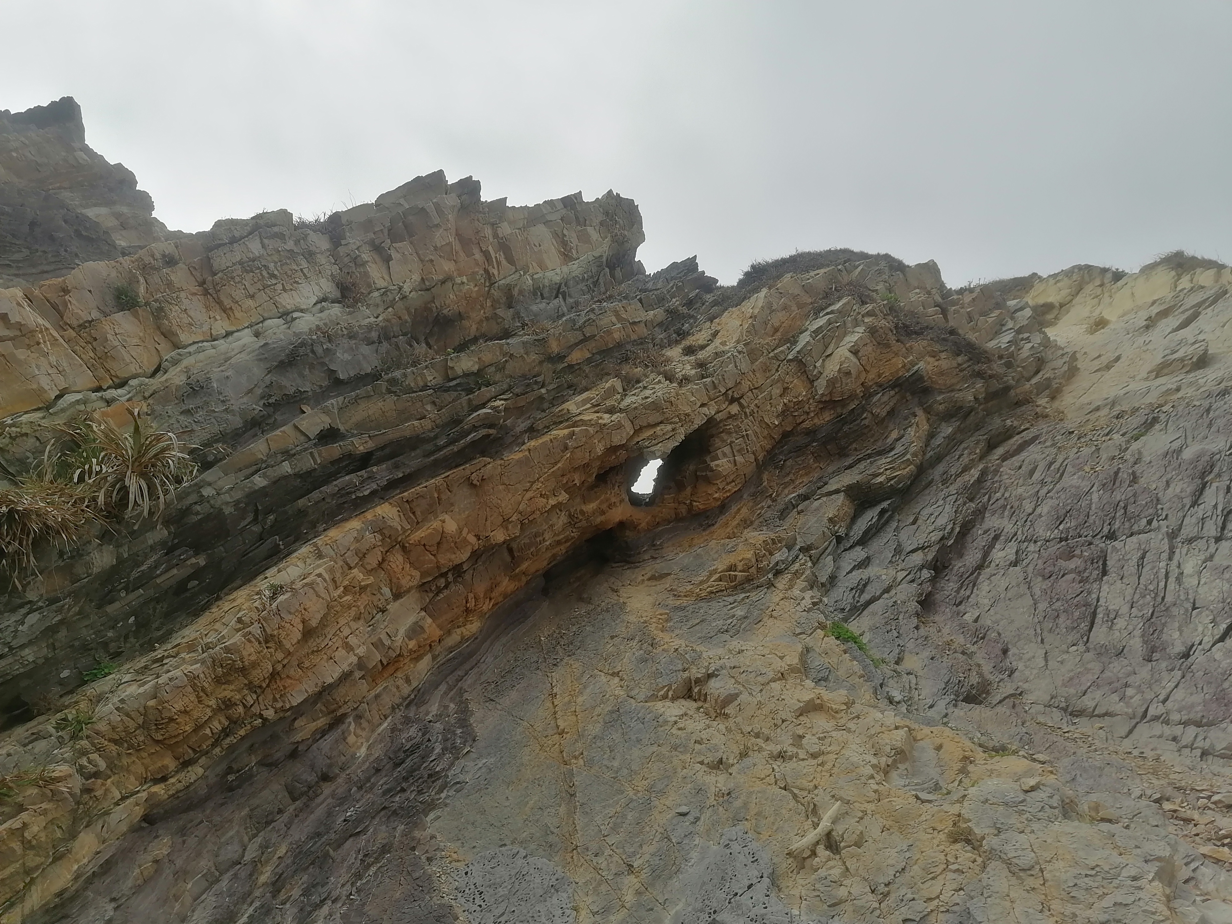
Hull Pot is known; Hunt’s Pot unshown. Revealer.
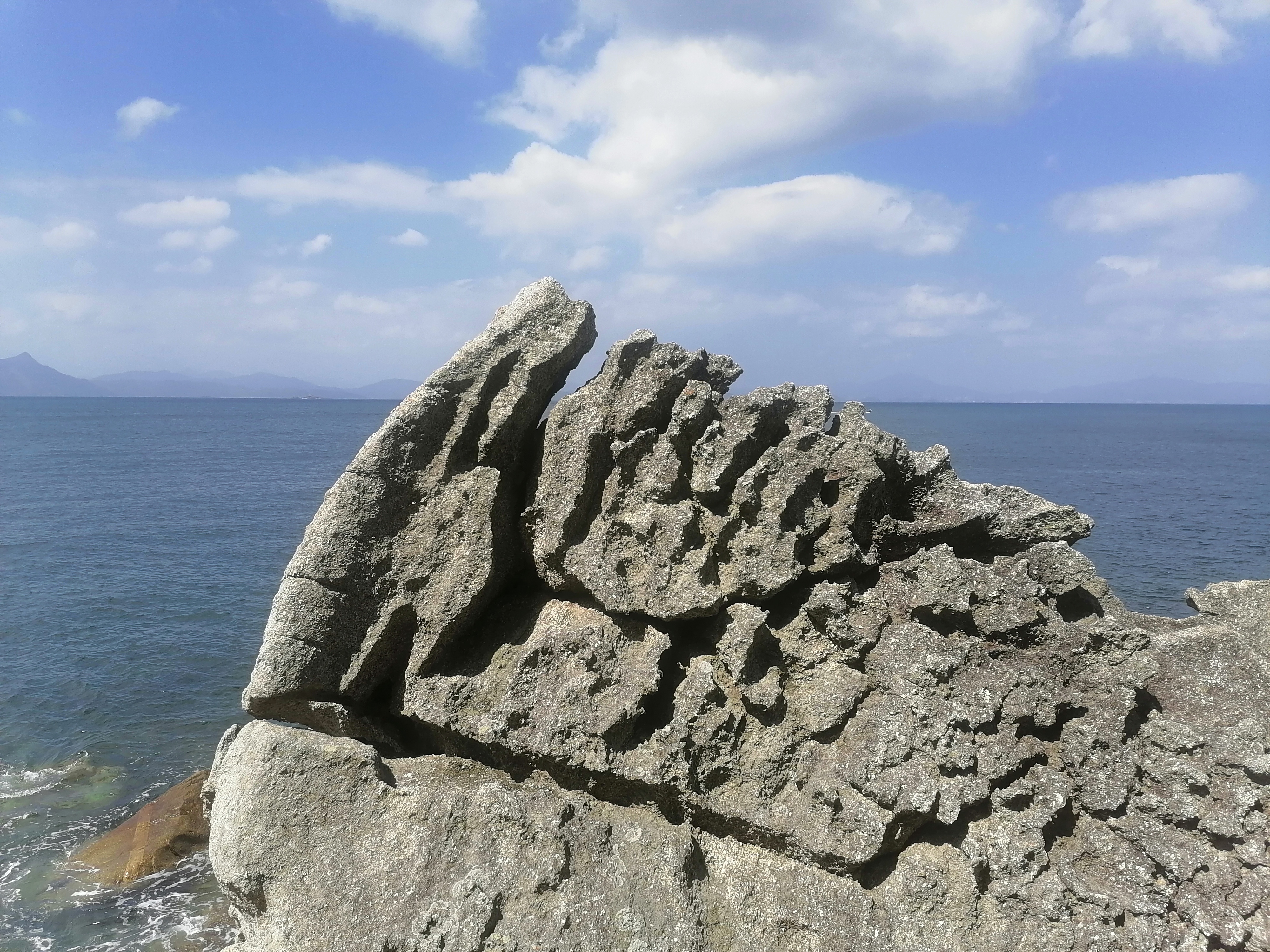
From within the cracked crevice; a crag distant. Dramatic.
Layers of limestone; collapsed downward. Fantastic.
Roots draped low; light reflecting glow. Unsystematic.
Flowers tumble outwards; water plummets loudly. Automatic.
Spikes protruding seats; stream into ground eats. Entice.
Stacked clumsy ledges; tufted lonely shrubs. Imprecise.
Solid without flow; frozen is the mass. Shelf ice.
Emerald filled cauldron; grasses swaying lightly. Paradise.
rambling
Holes in the Earth: A Wander
Manchester Victoria train station has a huge map on tiles. It’s part of the historic Lancashire and Yorkshire Railways station. Before split ticket applications. Before multiple rail network and ticket prices. Simpler times. A glorious end point, or a beginning, or an interchange. My Dad worked here many times. He fell off a ladder there too. Dad’s memory hasn’t been right since! Today, Friday, May 30th, a train departed at 07:21 to Leeds. Panda and I boarded it.
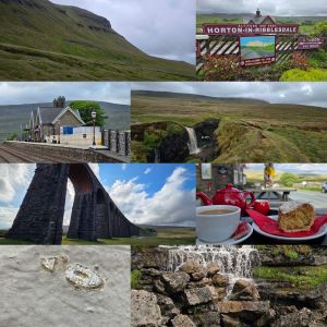
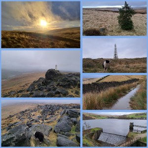
Hull Pot is surprisingly close to Horton in Ribblesdale village. A reasonable sub-hour wander up a gradual incline lined with stone makes for a decent ascent. The only difficult aspect was to turn left after around 5 minutes of leaving the B6479 (Pennine Way road) onto the Pennine Way footpath, just after Horton Beck, heading away from Brackenbottom. Head straight forward and ignore any left or right turns. Hull Pot is toward the hamlet of Foxup. Horton in Ribblesdale station has a small cafe and ample amounts of lodgings for walkers. We needed neither so trod onward and upward.
Hull Pot (91m/300′ long) is neither ceramic nor cannabis or belly. It is a quaint chasm (18m/60′ wide), opening into a gully (18m/60′ deep) of water and greenery, with thunderous cascading water pouring down a steep face of bare rock. The incredible flow of a visibly disappearing river thumped downward into a gap of glistening rock. Not the sort of place to dangle your legs unaided, yet certainly a place to watch every step. The next one may be your last. Watching Panda on a shortened lead warned me of how simple one step beyond could become fateful. Just a trip over the lead; And then a step to the right; Put your hands on your hips; and pray you don’t fall. No more Time Warp references. Sorry Richard O’Brien.
After the great view, heading as the crow flies towards the visible pathway up Pen-y-Ghent takes you away from Hull Pot‘s waterfall vista. Pen-y-Ghent, devoid of trees, shows the passage of time, weathered and individually steeply rising from a patchworked green landscape. Like Hull Pot, there are collapsed limestone features, just of rock, and streams like the one that submerges at Hull Pot only to re-emerge at Brants Gill Head. Sheep, and lambs during lambing season, are everywhere. They’re either looking for selfies or confused by Panda the border collie not trying to round them up. Today’s climb involved clouds and battering winds at the higher points, only to part for sunshine and calmness as I set off downward again. The view at the summit being somewhat shrouded by rolling clouds.
On the path downward, and barely yards from many passing feet sits another hole (Hunt Pot) in the ground. Again a waterfall slips into the broken gash of earth and a huge volume of water disappears from the ground above. Hunt Pot (60m/197′ deep) is a spot more than worthy of a good sit down, rest, and respite. Butties of radish and prawns, katsu coleslaw, and an avocado alongside a gallon of Vimto did the trick. I tucked into Ben Macintyre’s A Foreign Field, devouring a few pages as Panda rolled around in the grass. Photographs were taken of the hole and its waterfall, at which point, I decided the Ribblehead viaduct (detectable from the peak of Pen-y-Ghent) was now the walk’s targeted end point. That and the Ribblehead station, a few yards away.
Following the footpath, near parallel to the discernible flow of the River Ribble, Panda and I passed through farm fields, traversed High Birkwith, the wild flow of Coppy Gill, Brow Gill Beck, and the charming Cam Beck. Emerging onto Inman Lodge Road (B6479), turning right, the bends of Gauber Road reach Low Sleights Road (B6255) and The Station Inn (1879), at Ribblehead Viaduct. A brew, coconut cake, and a sit down were necessary. I’ve always found this area magical. It has an aura. It always calls me back. The oystercatchers, fossils, viaduct, green, and solace. My fortress of solace.
Batty Moss sits beneath the 24 spans of the Ribblehead viaduct. Modern diesel trains roll over this site and have done since the 2nd of August 1875. The picturesque bridge itself was constructed over half a decade. Over a 100 souls perished during its construction and remains of navvy camps can be found in close proximity. Thankfully smallpox, navvy brawls, and the perils of producing a 400m (440 yards) bridge are less of an issue for a rambler in 2025. The 32 metre-height (104′) may cause the odd person to stumble in awe, on a ground covered in natural potholes and squishy mosses. This sensation is often exasperated by steam locomotives crawling over the vast span of bricks and stone. After a wander seeking fossils within the bridge’s gigantic bricks, Panda and I wandered up to the old station at Ribblehead and hopped aboard a train to Leeds. Manchester Victoria was to be our final stop before home and bed. Feet up. Lovely day.
The 15 miles (24km) of walking can be found here (featuring: 2,464 ft/751m up & 2,231 ft/680m down).
Lately
The sight of the Duddon estuary around Foxfield has always tugged on my heartstrings. The rounded railway line hugs the coast and estuary like a wide horseshoe. It runs from Barrow-on-Furness to Millom and up the Cumbrian coastline. The Isle of Man lies out to sea, smothered in thick black clouds. A slight hue of pink gives a clue that sunset is somewhere towards Scotland. A crack of brilliant orange erupts along the northern horizon.
Geese honk and ducks quack as winds carry across the broad flat marshland. Occasionally trees jut out defiantly refusing to be swept away by countless vicious tides. Heather blooms in vivid yellow contrasting the slate skies of spring. Pockets of sky blue shine down on the isolated station of Green Road. A salty fragrance fills the air.
“I saw your message down the line
It gave me hope, it gave us time
So little
Time” – Doves, Strange Weather
There’s an eerie ambience to the region. As shadow on the western reaches of the Lake District. An area with less eyes upon it. The nuclear power plant at Seascale, just over twenty miles away, ensures Millom beach sees fewer visitors than other Cumbrian towns. Twenty six miles separate Whitehaven from Millom, yet little sign of tourism peers beyond the low coastal town. Hodbarrow Point lighthouse and an RSPB birding reserve gather a few feet on their travels. The remains of a windmill and a older lighthouse lurking over the headland. Remnants of another time.
Looking inland, hills dominant and mighty roll towards the many Lake District mountains. Black Combe lurks over the sleepy village of Silecroft. An algae-covered abandoned caravan shares a view back from the infrequently-visited station below. Swinside Stone Circle sits neglected to the east. Further north is Bootle. On a clear day, views from Black Combe are said to include England, Scotland, Wales, and Eire. Not bad.
RAF Millom Aviation & Military Museum parted ways with its collection and now houses His Majesty’s Prison Haverigg. Think Butlins and you’re on the right track. The jewel in the region is Ravenglass for Eskdale. Muncaster Castle and Ravenglass and Eskdale railway are delightful glimpses into the western Cumbrian life. They’re an escape from modernity into past worlds. Owls and narrow gauge steam trains. A Roman bathhouse is also worth a wander.
Wainwright’s walks may lay inland but every turn south of Seascale to Millom has something to offer. At Seascale there is also Greycroft stone circle. Less busy than the famous Stonehenge and more compact for photographers. Drigg’s dunes from Carl Crag to Kokoarrah Scar, its packhorse bridge, and clues to the WWII Royal Ordnance Factory can be found. Just ignore the Nuclear Decommissioning Authority low-level radioactive waste repository. Wasted land, indeed.
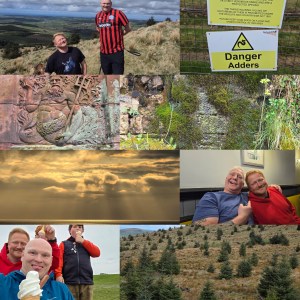
Only recently did a wander up Greenfield, near Oldham, across to the Trinnacles fill me with a warmth that is familiar. The need to share such views with loved ones is growing stronger each day. Whether at Dovestones reservoir or trudging along Cumbrian coastline, there is a hunger to live better and enjoy nature more freely. Seeing Dan, Van, Alex, and Damo made me hungry to spend time with good friends and family, as often as possible.
Kinder Scout Eggs
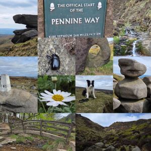
There’s a direct line from Brinnington to Hope. A world of differences between Ashburys and Marple. Too few similarities between Reddish North and New Mills Central. Yet the line from Manchester to Sheffield offers gems and escape. Friday the 25th of April 2025 led a path between Piccalilli train station and the quaint village of Edale.
Upstream to Grindslow Knoll, required a short wander through the village of Edale, passing the beginning of the Pennine Way. The Rambler Inn, The Nag’s Head, and Newfold Farm Cafe give a feel of what the tiny village of 400 centres around. An old and active primary school, set amongst the varied farm houses, country cottages, and Edale Parish Church show that life here isn’t all wandering. A path diverts from a truncated road over Grinds Brook. The protected stream will accompany mist walkers until Grindslow Knoll.
The paths start gentle with some undulating, before rocks, boulders, and scree start to appear intermittently. Heathers and moorland flora decorate either side of the funnelled valley. Eventually the bulk of Grinds Brook splinters into two sharp rises. Banking left involves a scramble, some choice pathway making skills, and a substantial incline. The views are increasingly dramatic. At the top, looking toward Mam Tor and Edale, much of the distance appears green and sprawling.
Following an old slabbed walkway, the journey takes explorers to a rock formation known as the Woolpacks. Peat bogs, heather, and alien-looking rocks litter, cluster, and emerge along the Kinder plateau. They mark the final wander to the peak of Kinder Scout and are a highlight for many walkers. Mermaid’s Pool, Charged Rock, and countless unnamed landmarks are worthy of an exploration.
The descent from Grindslow Knoll’s shady rear allows for farmland wanders along wide open pathways and a gentle jaunt on the home straight. Edale awaits. Edale sounds like a cake. The delicious Penny Pot Cafe banana and date oat flapjack was the only cake I had that day. Succulent. Alongside a cappuccino it made for a great reward. Before boarding the 1647 train, Panda found many a crumb landed in his fur. He promptly removed them before flopping back, head on the floor, for a nap.
Through The Leaves
Through the leaves, voices call out loud;
Beyond the tufted grasses wraps ivy thickly.
Through the greenery trees stand proud;
Along the jagged walls, bramble juts out prickly.
The murky Lancaster canal flows towards the sea;
A summer’s gentle breeze casts along its top.
Tits, swifts, and sparrow fly alongside bee;
Blackbirds hop along the mud and crop.
Feet slapping in the mud sinking slightly;
A fragrance of wild garlic hangs in the air.
Through the gaps and spaces, sun rays beam brightly;
Galloping dogs along the path they share.
Chattering and nattering creaks as trunks rub one another;
Regal flowers attract buzzing and zipping flight.
A ripple waves outwards from cygnets’ mother;
From Lancaster to Glasson Flight, a path wrapped in sights of delight.

Healey Dell Planning
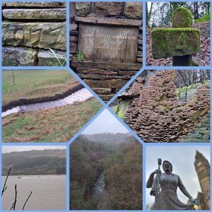
From Rochdale Town centre, passing the statue of Gracie Fields, the roads wound towards an abandoned asbestos factory, and here Panda and I skirted well wide of contaminated lands of Spotland. The so-called Spodden Valley asbestos controversy has scarred the 75-acre site. We didn’t go looking. Instead, we joined a sodden pathway along the River Spodden, heading toward Healey Dell.
Coupled with thoughts and a ball for throwing to make Panda chase, I hunkered down in the drizzling rain.I thought on how about in 2024, I must do something more human. Talk to the lonely. Comfort the desperate. Don’t be a knobhead. Think of others. Bless many, no matter their beliefs. Make the here and now matter. Improve tomorrow. Hug more. Push away negative people, paranoid eejits and fools. Surround yourself with passion, positivity, and vibes. Be kind. With the latter in mind, I threw the ball for Panda.
The river pathway crossed a road, with a higher path leading to a great viaduct, which I assume was once on the Rochdale to Bacup branch line. Passing over a rain-filled view, the bridge led to the old Whitworth station and the ruins of a stone rubbing mill. All soggy and damp. The pathway, more like a steam, carried on to the lower reaches of Whitworth village. Walking up Cown Park Way South, turning left on Tong End, the road led up to the Cown Reservoir.
This sprawling waterlogged body of a reservoir sat beneath crags and a wide valley. Up the valley, north-east, would be the source of the Spodden. At Fairies Chapel, with a cave carved by a waterfall and apparently a fill desk and writing area. The weather didn’t allow a push on to that location. Instead, a loop of the reservoir and a perusal of James Treacle Sanderson‘s memorial. The champion runner lived from 1837-1905 and appeared to be a local character of note.
James Treacle Sanderson dashed up and down the 440 yards of the Eastern shore. Panda and I squelched along as I chatted to various dogwalkers, and Panda sniffed a bottom or ten. A custard slice, a Christmas gift from Dad, made a good snack. Panda ate some dog treats, and we motored back to Rochdale in driving rains. On returning to Healey Dell, we looked at the viaduct from beneath, with Panda leaving a message for other dogs. The Healey Dell heritage centre had long closed, and daylight vanished. We headed into Rochdale Town to catch a Metrolink tram back to Manchester. A good ten and a half miles of wandering (16.8km) albeit on an afternoon of pouring rain.
Windy Hill & Blackstone Edge
Turning right from Newhey Metrolink Tram station, a short ride from Manchester, Panda, and I walked beyond Bird In Hand and The Bird In The Hand signposted public houses of Newhey. We carried on until an old stone bridge and turned left off Huddersfield Road (A640) onto a cobble path parallel to Piethorne Brook. The Brook ran behind a campsite, industrial estate, and eventually a steep cobbled road swept up over Ogden Reservoir.
Ogden Reservoir, in the Piethorne Valley, sits at the lower end of a strong of water bodies. Our path climbed west and away from the giant puddles. Crossing the Brook west of Ogden Reservoir, up some steps and beyond abandoned building foundations, the path stretched upwards towards Tunshill Lane. This battered old farm track lined with rock, split off at 53.6164428, -2.0610034. Here, the road became abandoned, waterlogged, and an ideal testing point for waterproof footwear. The odd abandoned jeep carcas lay along the way, and long lost gate posts led to nowhere in particular. After a gentle ascent, Windy Hill Transmitter sat atop a top, 389 m (1,276 ft).
Banking left from the Transmitter, the Pennine Way Bridge with splayed leg carried the Pennine Way footpath towards Blackstone Edge (1549’/472m) and whisky cave. The low cloud, fierce hailstones, and torrential precipitation tested my face for feeling and hands for the ability to withstand harsh weather. Panda bounded around joyfully despite the brutal onslaught of uncomfortable weather. The gritstone boulders make for suitable shelter in thunderous winds. The Lancashire-Yorkshire border hosts great views of Manchester, although at times, dark clouds hid the growing skyscraper-lined skyline.
The Calder, Aire, and Ryburn have origins here. Each flow east to the North Sea. Similarly, Roch and Irwell have feeder streams here, destined for the Irish Sea. Having read bits afterwards, I recommend a spot of research before rambling and looking for diverse routes to the top. There are plenty of inspirations out there. I opted for the look at a Metrolink stop and study an Ordnance Survey map for interesting features, then get out and follow a map in my head. An inspection of the weather forecast may have been wise, too. The Craghoppers rain jacket I modelled did the job, though it was touch and go!
Once you’re up, you need to take in the views, snap a few shots, or, in my case, cling to a phone camera and pray the winds didn’t rip it from my hands. The hailstone became sleet and then sideways snow. Hands numbed fast. My face felt battered. An about turn and a descent, against altitude and fading light later, and Panda and I boarded an evening tram back to Manchester. Not a bad afternoon wander. 4 hours or so, all in. So, where next?
Stanage and An Apple
Eat five fruits and vegetables a day. That used to be the message from health-promoting government officials. Now there’s a message doing the rounds: limit your purchases of cucumbers and tomatoes. Great Britain is experiencing a shortage of fruit and vegetables. Europe is not, on the whole, struggling for green foods. The labour shortages on farms in the U.K. experienced since Britain exited the European Union, are being mirrored by asylum-seeking boat crews and filled seats. Unemployment rates in the U.K. remain high. Jackets and aid packages are being gathered and sent to earthquake-torn Syria and Turkey, whilst homelessness in the UK spirals into greater numbers. The U.K.’s economy is fragile, strike action is booming, and somewhere Shell, BP, Tesco, Rio Tinto, Legal & General, Unilever, HSBC Holdings, Vodafone, GlaxoSmithKilen etc are all doing really well. With the world being really stable, Shaun, Christina, Panda and I went for a wander.

The train journey duration from Manchester to the historic two platforms of Grindleford lasted just under an hour. Opened in 1894, the station bridged the lower reaches of Burbage Brook. The station close to Sheffield is just next to the 3.5-mile long (5.7km) Totley tunnel. Our path led from the toilet in the café, up the picturesque upper tributary stream. After a few hundred metres or yards (if you choose), we crossed a wooden bridge and ascended a pathway to a higher level. The deep narrow gauge of Padley Brook is completed by trees, mosses, and steep drops. All were avoided, thankfully. The rich, clean air, a welcome greeting, has left the air of Manchester behind. The temperate rainforest along this route are apparently the furthest inland of their kind, in Britain. Our route led uphill, with relatively unchallenging steps and climbs here or there.
At White Path Moss, a little further north of Toad’s Mouth, the moorland drains and forms the source of Burbage Brook. The gently flowing stream starts somewhere near Stanage Edge. On our walk we didn’t spot any water voles, but we did hear a variety of birdlife including the hawfinch and wood warbler. Nature perfectly cuts into the bleak moorland and offers veins of life amongst the scattered glacial stones and boulders. Dry wintery grasses jutted out from soggy soil and bogs. Walking boots were a cosy necessity.
Soon after crossing a road, stretching over the Burbage Brook once more, and ascending a slope we arrived at Carl Wark (370m/1214ft high). This rocky promontory juts out and on it are the remains of an Iron Age fort. The view from Higgor Tor (434m/1424ft) back to Carl Wark is impressive. You can really see Carl Wark as an island sat atop the sea of the moor. After scrambling through Higgor Tor, we moved onto the Stanage Edge (Stanage means ‘stone edge’). So we were on the edge of the stone’s edge. Popular with climbers, abseiling enthusiasts, walkers and artistic types we meandered a fair distance down the crinkly fragile crust prominence. We explored Robin Hood’s Cave and also crossed the Long Causeway down to Hathersage village for the train back. The famous crags and Panda, loose from his lead at times, make for heart-in-the-mouth opportunities. Luckily a well-behaved and heavier supervised dog could not be found. Panda behaved well when passing by St Michael’s Church and didn’t dig up the remains of the legendary 2.46m (8ft) Little John (Robin Hood’s buddy).
As we boarded the train, all shattered and hungry, I read about the Fat Boys Stanage Struggle and vowed to myself never to enter. The accent from Hathersage (91m/299ft) upwards is firmly not on my bucket list. More likely, a viewing of Pride & Prejudice filmed at parts of Stanage Edge. Perhaps, in the near future, we can wander up there again. The 13.5-mile (22km) route was most enjoyable in good company.
Back to Daisy Nook.
Wandering the sloppy banks of Crime Lake, a buzzard flew overhead, and my dog Panda flashed his muddy black and white coat as he bounded ahead. I hadn’t visited Daisy Nook Country Park in ages. On a damp December afternoon, I left Newton Heath with Panda after a brief lunch.

The walk there involved passing through Clayton Vale, crossing Clayton Bridge, heading under the railway viaduct by Millstream Animal Sanctuary along a grim industrial road called Green Lane. Green, in other parts, but not by Lord’s Brook and the stinky sewage works. Trudging through the soggy pathway at Medlock Valley Fisheries, the rough path saddled alongside the River Medlock and nearby railway. At a footbridge by Hadfield Wood Recyclers, a left turn headed us onto the Manchester and Ashton-under-Lyne Canal Hollinwood Branch. This is a pretty area within Greater Manchester. It is worth visiting every season.
The pathway sweeps along ruins and flooded canal troughs until the M60 motorway disects the route, offering a bleak metal bridge. Afterwards, the canal returns, flooded by plants and trees overlooking hither and dither. By Lumb Lane and below tiding stables. A cafe and car park adds accessibility to the various pathways and bridleways.
The unique Daisy Nook Country Park features water Sammy’s Basin, Crime Lake, and Bardsley Canal. Water creatures are varied, from coots, moorhens, swans, and so on to otters and river rodents. Dozens of old canal relics remain, including double locks, bold staircase locks, and odd right angle turns. The Waterhouses Aqueduct passes over the River Medlock. The views above and below are worth the steep walks on either side.
Author Ben Brierley published A Day Out, which was set around Waterhouses and featured an area called Daisy Nook. That moniker stuck with locals. The name Crime Lake comes from Crime Valley, which isn’t a Scandinavian drama. Crime used to mean land intersected by a stream. Now, it’s more associated with crime. Fishing without a permit is a crime.
Daisy Nook is a special part of Failsworth, an area of Oldham Town, and a place my Gran used to live. Crime Lane Aqueduct is as picturesque a place as you can possibly see. This is a unique spot to sit and enjoy the sunset and explore Benjamin Outram’s ironworks lay under the outwardly brick appearance of Crime Lake Aqueduct. This hybrid bridge was a place I visited with Gran and Ernie when I was young. Daisy Nook still has magic and a draw. Many dogwalkers and friendly people said hello, as did a curious kingfisher and a big grey heron.
On the pathway back, instead of taking the right turn alongside the railway after the Hollinwood Canal, I crossed the wooden floored bridge and turned right immediately. A cycle path marked by solar lights guided us back towards Clayton Vale. Sadly, at Taunton Brook, we had to go off-road to avoid the deeply flooded pathway and then scramble around other parts. At the Greenside Lane (Droylsden) to Edge Lane path, it was necessary to double back and head up Clock House Avenue to find a route to Clayton Vale. That negotiated it was plain sailing, and we made it home for a deserved dinner.
Plan C.
How do!
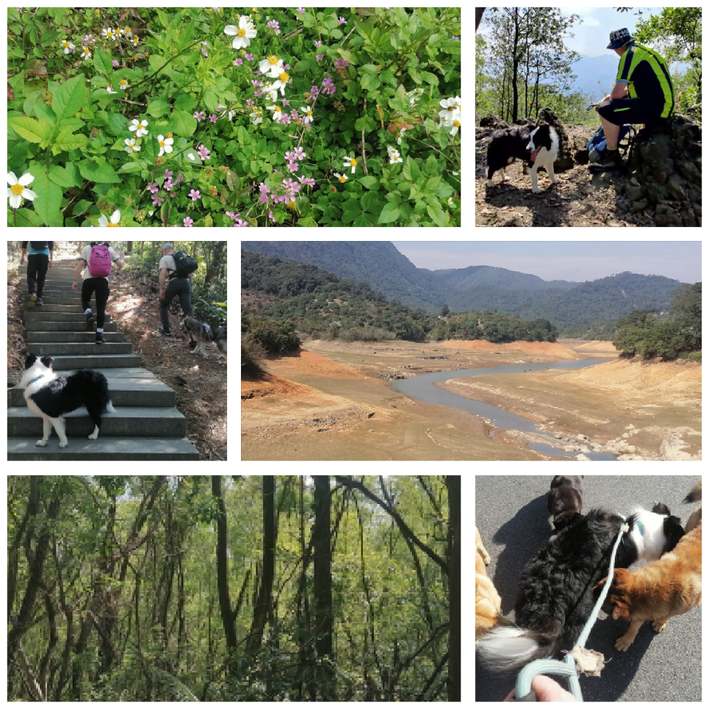
Today’s plan C ended up at 崖山古 (Yáshāngǔjì, cliff mountain historical place). It wasn’t meant to be this way. Moiz, Aaron, Matt and I, alongside two dogs had a roundabout wander.
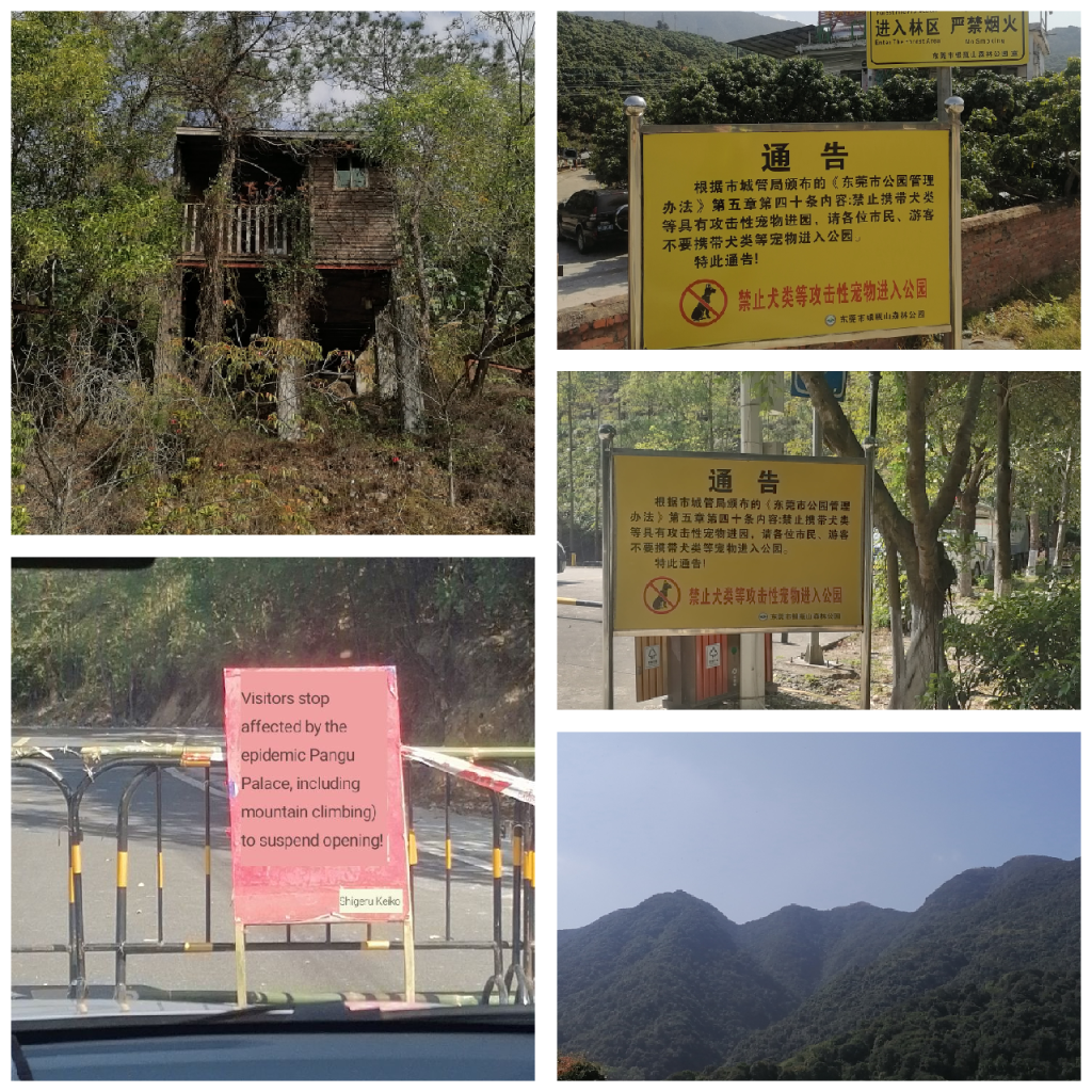
The Yashan mountain monuments are located north of the Li Village of Xiegang, a town in Dongguan City. The approach is made up of abandoned theme village with hollow lodges and skeletal outdoor structures, which suits the tombstone-lined face of the short hillock. A round trek loop of around 6km is possible, assuming you brave the ridges and scree slopes surrounding a small pagoda at the top. It’s ideal for walking a dog. Panda and Matt’s dog certainly enjoyed it.
Tan Xian Temple (Ming Dynasty, 1882) was rebuilt in 2001. It’s brick and concrete isn’t so appealing for tourism, despite the green mountain location. The site has been protected by the Dongguan government, however, due to the cultural value of a poem inscription and something about a waterfall. We didn’t find a waterfall. The eastern flank of the hillock unfolds to a large dry quarry. Not exactly the lush wetness of a waterfall.
Plan A had been BaiYunZhang (白云嶂) over at the edge of Huizhou (惠州) and Dongguan. On arrival by Didi car we found the road by the Pangu Temple (新圩约场白云嶂盘古庙) we found a barrier and two guards. Also, a half dozen dogs. The sign translation shown as something akin to “YOU SHALL NOT PASS!” There was no pleading with the guards. Something about a virus case had closed the temple and all hiking routes.
Plan B was equally disappointing. Yingpingshan in Dongguan is the tallest mountain and part of a huge nature reserve. No dogs allowed. Not even if you pick up their turds. No well-behaved dogs. Go away dogs. So, after a stroll around a lower reservoir, Aaron and Matt located a small hillock for us to explore. Plan C, in the recently arrived 20°C temperature, wasn’t the worst way to end a second Tiger year trek. Better than house arrest, for example.
That’s all folks! Ta’ra!
Hot steps.
晚上好 Good evening. 你好。Hello!
The trek today was bloody tough. Tougher than it ought to have been. I’d had a big breakfast, two trekking bars, two bread rolls stuffed with optimism and sustaining properties. Three litres of liquid and two well-packed ice-lollies. Yet, something was missing. A double dose of electrolytes in tablet form on two occasions was also deployed. Yet, it was a tough slog at the final furlong. The 30 degree heat and the lack of opportunity to hide from the sun were unkind on my delicate physique.


The trek started somewhere between relentlessly hot and smouldering heat more befitting the devil’s home. A jolly group of wandering enthusiasts gathered having been dropped from a convoy of cars at the foot of a hilltop road. Here a few stretches and introductions were made. The local security guard took a few details for the Dapeng trekking pathway requirements. Here on, we wouldn’t see a shop or house for hours.
The last leg of the meandering pathways into Xi Chong (西冲) village was under the cover of darkness. After using my eyesight for as long as physically possible, I switched to 900 lumens of torchlight. The results were splendid. I spied various toads, geckos and even a praying mantis. Also, it helped in avoiding the bloody big orb spider webs.
Armed with a Snickers chocolate and nut bar, at least two extra litres of water (thanks to kind and caring people) the latter stage of up a bit, down a bit and up some more before down was possible. Cramp in both legs and dehydration had been a real stumbling block since our stop at a waterfall and stream. The sit down took my lagging stride but it didn’t ruin the views.
Throughout the walk, people were people. Stripped away of the hustle and bustle of life, and the majority of people I have met in China are warmhearted and friendly. Rehmy the ‘Chinese Lara Croft’, Sophia and two very kind students shared fruits and words. That’s exactly the reason I joined the Global Hikers walking group in Shenzhen today.
The route takes in mostly coastal pathways, scrambling over rocks hot enough to fry eggs on and scrubs of coastal forestry. Expecting bugs, I was armed with citronella. Expecting sun, I was armed with factor fifty sunblock. Expecting scree and slippery bits, I wore my trekking trainers. They fitted the job perfectly. The up, down and around the bays overlooking the distant Hong Kong under bright sunshine certainly feels like a walk. It’s delightful at stages and testing at others. I have no regrets.


谢谢你。Thank you kindly. 再见 Goodbye.
Junbesi.
One kilometre up. Another one down. Toughest climb and hardest descent of my life. Sweat, tears and muscles burning like volcanic lava. At stages the fumes of my depleted energy switched my head into autopilot. I walked aimlessly and without thought. Vacant. Empty. Even desperation and hunger departed my mind. My soul carried me. Hope hadn’t slipped away completely. Bruised worn feet made it through the darkest evening to night. A bed and a meal waited for the day’s end. A great sleep followed. Two different years, two tough challenging experiences. Twice. Twice, the walk carried on.
Yesterday was such a day. A tiring cycle ride to play football. A testing first half-hour. A stretched thirty minutes followed. A near empty final third. And then. And then the ride back. A thirty minutes cycle ride doubled in time. Ten grueling ten kilometres. Sweat. Pain. Tears. Two cups of yogurt and a litre of water. Knackered. Back against the wall. The cycle bad become the rupture machine. A test of stamina and mind over matter. The Junbesi of Dongguan in high humidity and subtropical heat. I crawled into bed following a shower. The kind of shower that involved slumping and letting the warmer than usual water just hit from above. Careless shower. Even sleeping in bed I fed mosquitoes and didn’t care. Exhausted.
Tough moments are there to be overcome.
Stage XII: Serendipity x Terra
Nihao! 你好!Hello!
Lee Child mentioned in his novels, that his character Jack Reacher never goes back to a place he’s visited. It’s a state of mind. I’m not Jack Reacher. I’m too short and not as strong. I went back to Dali’s Ancient town in a car with Qiézi (茄子) and the trio of girls that set out with our driver in the first place. It had only been for two nights away, but such was the refreshment of the trek, it felt longer (in a good way).


I checked into the Jade Emu Hostel once again, who were so busy that they put me into a neighbouring hotel. A room is a room. Then it was time for a coffee at Movie Time Coffee Shop, surrounded by a chilled setting. Qiézi joined me for a cuppa and we talked a little. Two dogs, one tiny and one medium in stature had a fuss, before climbing all over us for hugs and attention. It was a pleasurable end to a good day.
The following morning I met QiéZi with Xiao Jie, one of the girls from the trekking, and we wondered to a set of temples (including Gantong temple and a nunnery) and trails on 苍山 Cāngshān, starting somewhere near Dali University (by Xuefu Lu). The gentle upwardly walks led to BuLuoSi temple and a view of numerous waterfalls. We didn’t return to Dali’s old Town (古城, Gǔchéng) but instead bypassed it to meet QiéZi’s good friends Lin and Spirlo. The once top 13 city (in terms of size – in the year 1000AD) is a sprawl of farms and villages along the Cāngshān range. Lin and Spirlo live at the far end of along road, and down an alley, in a lovely little farmhouse surrounded by gardens rich in vegetables.
We’d gone from orchids, rhododendrons, camellias and birdsong to a relaxed house filled with warmth and harmonies. The six cats with their talented masters of Lin (from Fujian) and her Greek husband Spirlo were great company. Plenty of conversation was had from talking about the didgeridoo to football to camping and trekking.
The final full day involved a filling breakfast of omelette and salmon at Serendipity cafe and diner. It did exactly what it said on the label filling my belly to the brim. Not a bad iced coffee indeed! Then, a wander to drink fruit juice, natter and following that a gander at the market on Sānyuèjiē (三月街) and all the marvelous oddities for sale. A fire festival is due in Dali around about now. After which a spot of planned spontaneity was called for, planned and put into action. A relaxing mix of sensations followed. I’ll write about that another time.
The day culminated with the eating of tiramisu at the Terra cafe. It was by far the best tiramisu I have ever experienced. Qiezi, Xiao Jie and I were eventually joined by Echo. As is very Echo, she broughta new friend along. Farola talked star signs and birth times (08:37, if you aren’t wondering). They ordered more tiramisu but by then I was stuffed like a well-fed teddy bear at a teddy bear factory. I’ve tried many and few have satisfied. It took me a while to realise that Terramisu wasn’t a spelling mistake but a variation on the cafe name in the food type! And, then Qiezi and Xiao Jie bid everyone goodbye. It could have ended there and then, but the magic carried on.

I was invited by both Qiezi and Xiao Jie to Lin and Spirlo’s farmhouse. Qiezi had taken the responsibility to feed their six cats. I pondered the difficulty of getting from there to Dali Railway Station. Echo asked me, “What’s stopping you?” She was completely right. Nothing was stopping me. I hugged Echo goodbye and I’m not ashamed to say a few tears formed in my eyes. Emotions can be high at times of homesickness and when you really appreciate great friends.
Leaving Dali behind, I feel like I will return. There’s much more to explore and within the whole province of Yunnan, there’s too much nature to ignore. I’ll probably be back. The final night lay on the ground staring at stars with Qiezi and Xiao Jie was special. Qiezi made a few very wonderful photos. Sharing the sights of five shooting stars in one night was a unique experience.
Home is where the heart is. Your heart doesn’t have to just be in one place, at one time, or with one person. Hearts are open. Making a connection irrespective of time and space is a wonderful experience. There needs to be more love and peace in the world. In the words of Qiezi, “Everyone is free spirited and an adventurer. Independent individuals but connected together.” It’s been a delightful and unique time in Yunnan. My heart feels warm and my head clearer than ever. Something will travel with me from these days that started in Dali and I leave behind a piece of my heart.


“We’ll meet again, don’t know where, don’t know when, but I know we’ll meet again some sunny day.” – Vera Lynn song We’ll Meet Again written by Ross Parker (Mancunian) & Hughie Charles (also born in Manchester)
Zaijian! 再见!Goodbye!
Stage XI: Abuji Cuo
你好!Nihao! Hello!

Anticipation surrounded the morning. We after off for a selection of steamed, boiled and grilled breakfast mainstays of Chinese breakfasts (across this huge nation). With that, those without raincoats purchased those disposable rain jackets designed to be worn for an hour or so. The kind that would make Mr Macintosh roll in his grave with tears. Not to mention environmentalists. Sorry Greta!
Abuji Cuo (阿布吉措) sounds Japanese. It certainly seems unlike Mandarin Chinese. It’s surrounded by the Ajiagang Mountains and stands high over meadows and scattered pasture houses. It’s well off the beaten track and fairly clean of trail litter. The name comes from one of the many local Yunnan languages and people but I couldn’t find a true translation or meaning. It is apparently very holy. The China National Highway 214 and Xiangli Expressway (toll road) are to the west. Here a dirt track leads under two bridges (the new Shangri-la railway line).
The car journey led us to a gate. It had a weight on one end and two barriers across the path ahead. Here began the wander. The base camp was labelled just that. The pathway was an old track, now used by loggers as well as the original farming people of these steep damp foothills.
Rounding a bend, the footpath exited the road, passing between free-range pigs and towards a slim yet fast-rushing stream. Our group of six with a local man tagging along crossed the stream over felled logs now doubling as a bridge. Here the path gently led to an open plain standing below the face of the mountains. The phone signal had soon disappeared – something good for the quiet ahead, but unusual on mainland China.
After passing through the deep lush green meadow, the path banked left over several bubbling streams complete with stepping stones and bridging points. Here the path zig-zagged up and across gaining altitude fast. It’s steep sections were marred by slippy sticky clay interspersed by sharp shards of rock. The sides of the path displayed vivid biodiversity with wild gooseberries, something like rhubarb and wild strawberry plants amongst the plethora of greenery.
A local Yunnan man Qī Lín(七林), a girl from Anhui, a student from Guangzhou, a girl from Heyuan, a girl from Hubei, and another girl (from somewhere in China) walked up in light to heavy rain. The thick cloud thinned and grew in almost pulsating slow motion. At times the valley behind seemed hidden. At others it became a tapestry of various green hues.
The imposing mountain to our right shoulder (mostly) could have been Skull Island from the King Kong movies. It’s ferocious face looked brittle and completely impervious to those intrepid climbers who like such nooks and crannies. The artistry of nature had created such a detailed spectacle. The top range of peaks could have been a crown, or a bed of thorns. It truly sets the imagination running as wild as the fight ravines within.
The stream accompanied the walk up, and at times became the pathway giving clear flow to passersby in need of a quenching swig of freshness. After one small lake the path hugs a slope covered in knife-sharp vicious broken rocks. Blue flowers emerge where the rocks allow soil to gather. The rug of land is unforgiving and not a place to stand in awe of the view ahead.
What lies ahead is possibly the greatest lake view I have ever seen. The cauldron of clear green and blue water appears impossibly deep. Local legend has it that there is no bottom to the icy water. It’s entirely believable. The edges look crystal clear but beyond that, well diving would be the only way to know what lies beneath. The surrounding slopes are mixed in terms of harsh angles but most are barren. Life is not easy. We were stood around 4300m and the highest point is about 500m above here.


The caldera-shape of the valley spreads wide and long. From numerous vantage points it’s hard to tell what started this paradise on high. The geological features and lay of the land are mesmerising. It grips your heart whilst choking your throat of air. You can suddenly become breathtakingly awestruck. You look. It stares back blankly. Rumour has it, if you speak to loud then rain will come. Here at the top, for the most part, rain eluded our group. The feeling of healing as you look around you at the majestic landscape is overwhelming. I couldn’t help but feel my heartstrings being tugged and a tear in my eye. There are few places left that are this pristine.
Shangri-la (香格里拉县/Xiānggélǐlāxiàn) is a county and a city that draws it’s English and Chinese names from James Hilton’s Lost Horizon. It influenced China to rename the Yunnan city of Zhōngdiàn (中甸) in 2001 to Shangri-la. The Shangri-la of Hilton’s writing could have been Kashmir, Tibet or anywhere else along the Kunlun Mountains of the author’s description. But, if James Hilton had have travelled to Yunnan and Abuji Cuo to see the steep cliffs, loose and rocky earth scattered with flora and colour, he may have set his chapters here.


Abuji Cuo is about 4 to 5 hours (around 17-20km) up and only accessible from May to October. The gate (near a temple) is manned and access denied at other times to allow ecological balance. Non-slip shoes are essential, although I spied a few people in sport shoes. One unlucky soul was sporting a sprained wrist, leg injury and looked sheepish. Her local guide was guiding her down ever so slowly. The muddy pathways demand good grips. The steep falls are lethal in appearance. And there are yaks. Yaks can surprise from above, and they did on our walk once or twice. Death by yaks would be rather a bad day at the office. The road starts between to Bixiang and XiaoZhongDianZhen.
The hamlets of Nigeria, where we drank milk, and the Niguqe (尼古个) hamlet are sparsely populated so expect to see few people. The nearby hamlet of Gangzhemu (岗者木) is close to a scenic spot called Bitahai (碧塔海景区) but that could easily be a different world. However, it would make a tasty multi-day hike with camping. Scope to return? Head to Bengla (崩拉)?
The walk back down was every bit as unforgettable as the ascent. Ancient woodlands caked in drapes of moss and lichens, the sound of a chorus of different birds and the smell of flowers give your senses a tasty day. After reaching the pasture at the cliff face, a local woman gave us hot potatoes, and well wishes. After that we walked to the road and were greeted by a drift (or drove) of pigs. The curious tail-wagging group led us to discover some local fruits, to which nobody knows the name. QiéZi gave me one that looks like it is shaped like a bottom. Rather cheeky!


Soon after Qī Lín (七林) introduced us to an elderly farming couple. Here we had hot milk, sour homemade yogurt and delicious cheese. The wooden cabin was a good end to a day’s hike and we bid the farmers goodbye before jumping in a car back to Shangri-la. The unique and diverse holy Abuji pasture would occupy our minds for the evening and I’m sure that visiting there, we gained something more.


Grid reference: 27.666254378118495, 99.90886934422305 (Abuji Cuo) to Bixiang village (27.604282621386876, 99.78759058373961). 14km distance as a local chough would fly.
再见!Zai Jian! Goodbye!
Stage X: Shangri-la Too
Nihao! 你好!Hello!
I awoke on Wednesday just after 05:30. I’d had about 5 hours sleep. The rooster may have fell under the category of an unwanted alarm clock. Bizarrely, I couldn’t nod off again. Yesterday evening had been quite subdued. I’d hung out with Echo and QiéZi (茄子) in their funky friend Cici’s juice and snack bar. Over blueberry and banana toasties it was decided that QiéZi and I would visit the legendary Tiger Leaping Gorge (虎跳峡/Hǔtiào Xiá) on the Jinsha River (Jīnshājiāng/金沙江) in Lijiang Naxi autonomous county (Lìjiāng Nàxīzú Zìzhìxiàn/丽江纳西族自治县). The chance to see more of Yunnan (云南) wasn’t something to pass up. Besides which QiéZi is a wise traveling companion.


Checking my phone at 05:45, I see we’ve grown to a group of 6 people and we’re headed to a trek somewhere near Shangri-La county (香格里拉县/Xiānggélǐlāxiàn). I have until the 3rd of August to play with, so as the Reverend Gallaghers said:
“You gotta roll with it
You gotta take your time;
You gotta say what you say;
Don’t let anybody get in your way.” – Roll With It, Oasis
So, I gave in to not being able to sleep more, grabbed a coffee at the cosy Song Sisters Bookshop and Cafe before departing the fantastic hospitality of The Jade Emu. Song and Dave are most welcoming owners and have knitted a fantastic community for those wishing to pass through, or stay a little longer.
Nomadic QiéZi arrived with the driver and we set off, with her friend Cici to collect two more friends. The journey began with a chattering driver, who gave so much information along the way, and recommendations. We stopped for hot corn and potatoes – although I declined the corn. The driver also provided yogurt and a selection of fruit. QiéZi gave me a coffee early on too, so a welcome toilet break arrived at an ideal time. No sooner had we left than we arrived, give or take four to give hours of driving.
Our group of six entered a restaurant and ate delicious breads, with a sweet cottage cheese and a meaty potato dish. A jolly day with a few games of wéiqí (围棋, sometimes called Go). The game involves black and white stones and is a territorial game of strategy. There are variations on the original but for this occasion, it was first to five in a row. Simple. Fun. Entertainment.
The evening involved sitting on our arses talking and planning tomorrow. The heavy rain brought about my several freakish weather fronts will challenge the next two days and any potential wanderings. The group have their eyes on Abuji Lake (阿布吉错). This may prove overambitious, but not every journey has to complete. Some off the beaten tracks lack tracks at times. The hard to find details for the trail aren’t exactly clear or enlightening. If the walking starts at Jiulong Yangchang (九龙羊场) then all is good.
Right now the courtyard of Desti Youth Hostel, complete with two big cute dogs isn’t a bad place to chill and await the next day. With a giant screen showing an Indian movie and a variety of games in a covered area, it’s a great place to be.
Zai Jian! 再见!Goodbye!
Stage IX: Dali (and the mysterious Aubergine)
你好!Nihao! Hello!
Salvador Dali has nothing to do with the Yunnan city of Dàlǐ (大理). The draw to Dali has been the art district, cycling, the coffee and cafe culture and my friend Echo. Also, wherever I’ve been in China, everyone mentions the comfortable weather of Yunnan.
Echo or Eck published a poetry little picture book recently. She’s made her nomadic home in Dali. Here she’s honing her artistic talent, existing comfortably and living happily. I dropped by (via Guiyang and Kunming) from Chengdu, Sichuan province to say hello. I told Echo I’d arrive on Sunday but Saturday afternoon, walking by the Terra coffee shop seemed as good a time as any. Yunnan is great for growing coffee and Dali has no shortage of coffee shops.
A good old chinwag and catch up preceded a walk through the ginnels of Dali’s ancient old town to a door in a wall. The door was open and smooth tempting beats were gently rolling out. Ducking below the low entrance, an Old-styled yard with greenery and tables greeted us. Echo’s friend (or should I say complication?) Yali and his brother were serving up delicious pizzas. The pomegranate tree nodded towards the range of locally-produced liquors. Here Echo introduced me to Myrtle Bee, a girl named QiéZi (茄子 or eggplant/aubergine). There were several others but my recollection for names had by now been overwhelmed.
Meanwhile my mouth had been delighted by a cream cheese and tomato pizza, followed by a further shared pizza with zucchini and deliciousness on top. The pesto dip was a smart move. A side salad featured a baked cheese and rocket lettuce. It was a bit too salty for my pallet, but overall very tasty. The funky beats faded and a disappointing bar called King Cat followed. The music wasn’t my cup of tea, but it saved wading through deep puddles and high-bouncing rain. After a later than expected hour, I arrived back to the Jade Emu China Australia International Youth Hostel, only to find my swipe card to enter didn’t work. The matter resolved itself and I slipped off into dreamland.
I didn’t need a sign for Cāngshān (苍山). The imposing green and cloud-kissed range of peaks. The Didi taxi driver from Dali railway station to the hostel had given ample chance to view the waving weaving green peaks. So, with a late rise and a belly full of good food, I set out for a waterfall recommended by a friend. On passing a set of small waterfalls, I headed up a track made by goats or sheep or possibly very narrow humans. The steep track disappeared and I soon found myself jutting between soft earth, trees and huge fluffy plants. By which stage I’d reached a ridge, with a very confuddled water turbine worker, who then directed me up a hidden pathway towards the top ridge. It was a tough but pleasant trail.


The undergrowth swept away to reveal a near-hidden valley tucked between two mountain ridge lines. I wandered down, dipped my feet, watched the butterflies and listened to the idyllic birdsong. One can definitely relax when clouds cuddle the mountains above, and gentle breezes softly drift around your chest whilst your feet are in chilly flowing waters.
Once again Busa called for dinner. Their second opening night led me to catch up once again with Echo, her Yali and other friends. The waitress Hazel, from Changde, took an interest in the book I was reading. A few days later, the tatty and soggy paper back was left for her to read. Echo’s friend QiéZi invited herself to my next walk the following day. Cāngshān (苍山) once again would be the wandering space.
With little barefooted QiéZi (who is no taller than 155cm), we set out towards the Cloud Jade pathway of Cāngshān. Passing the chair lift to our left, then our right, then left again we ascended. Stopping for Pu’er tea, a coffee and a snack at a park Police point seemed reasonably normal. The local boss had her grandson playing with leaves as she served a refreshing brew to us both. We left behind the options of hospitality and wandered paths here, there and everywhere. My pigeon Chinese and a relaxed mood made the afternoon to evening a satisfying and contented ramble.


By about 8pm, after almost eight hours of moving forwards, we descended through dark shadows and paths more at home in the deepest darkest parts of JRR Tolkien novels. Emerging from utter darkness, with only the company of fireflies, seemed to take a while but the adventure was nevertheless a great day out!
The next day (which is today, now) I decided this town needs a little more of my presence. I decided for the remainder of the holiday that I’d be here or there, but not so far from Dali. Why not? A place that puts a smile on your face and opens you to the nature around it, isn’t all bad! Ian Fleming penned some of his books in his Jamaican home of Goldeneye. Perhaps a few days in Dali and I may have found my Goldeneye.
However, a few hours later, I changed my mind. Have shoes, will walk. I will keep looking for answers and smiles.


Zai Jian! 再见!Goodbye!


Stage VII: Chaka
你好!Nihao! Hello!
I arrived at Chaka Station (茶卡站, Chákǎ Zhàn) 151km from the gargantuan Qinghai Lake, and 300km from Xining. The smooth railway journey was sandwiched between sweeping views and seemingly endless tunnels. The train ground to a halt on the single track. A chugging diesel engine had swapped with an electrical unit at some stage of the journey. I guess that hour where I had a nap.
The station was immediately at the gate of the scenic area. Chákǎ 茶卡盐湖 Salt Lake (Yánhú) has a salted bed. That’s the reason for such a high level of reflection. There are salt mines around these parts. It’s known as a photographer’s wet dream. For 60RMB (less in off season) and a further 50RMB to board a quaint sightseeing train, there’s much to be seen across the 105 square kilometres of lake. I walked the 3km to my hotel, checked in and then walked back.
Chákǎ is a Tibetan word meaning salt lake. It’s located around 3059m (10,036′) above sea level. That’s probably the reason the Gaoyuanhong Inn has disposable oxygen canisters for sale. That and some salt products. Salt seems to be a thing here, having been mined for three millennia. I read the salt below the water can be 5 to 15 metres in depth. And, every time it rains more salt is brought down the valleys. The once sea area keeps providing. Some claim it is infinite.


There are sightseeing platforms and decking everywhere: a tall 30m tower; a platform with the words ‘I love Caka’; two hearts in love as a platform; and the mirror of sky squares. It’s a real draw for tourism, apparently attracting over a million visitors a year. Sculptures are present and some honour the Wuxian tribes who once harvested the plains and salts of Chaka. Closer to the present there’s an abandoned salt factory and salt-mining transportation hub. There are yachts, helicopters and all manner of ways to see the lake’s splendour.
A smaller lake, Sky Number One Lake, is a little east of Chaka Lake. However, I’m not rushing to it. My experience of saltwater is that it stings broken blisters, makes you really dry and forms a crusty layer over your skin. I’ll take it easy and enjoy the sunrise then have a wander.


Zai jian! Goodbye! 再见
Stage VI: Xining & Kumbum
Nihao! Hello!
The train rolled into Xīníng (西宁) and I skipped immediately down the stairs, found a wee man’s room and had a piddle. As exciting as the journey was, I could not go to the toilet. The views and valleys were something else. The tunnels were also rather long, and I didn’t want to gamble on missing any scenery whilst urinating. Hence, the urgency at Xining’s plush railway station.
Xining is the provincial capital of Qinghai (青海). It is home to Mongols, Tibetans, Han Chinese, and Muslims (Hui). It has a mixture of vibrant cultures. Walking around Lotus Lake (Mayigou Reservoir), I witnessed Tibetan music, Muslims walking and relaxing and Han Chinese carrying umbrellas in the afternoon sun. The train journey into Qinghai crossed huge expanses of grasslands, tight valleys and mountains beyond mountains. There’s nature in and around the area. The WWF (not the wrestling lot) have an office here.
The language around here is different, it’s Mandarin but Qinghaihua dialect. Like the language the cultures and food are quite diverse too. Almost as diverse as the routes of water within this province. The three great rivers of China have their sources in Qinghai. The Mekong, Yellow (黃河) and Yangtze rivers all begin here. Xining’s Huángshuǐ hé (river/湟水河) is a tributary of the Yellow River.
I started Monday by moving hotels. My first choice hotel had no vacancies for two nights so I moved to the Xinsu 1357 Inn. I should have stayed here sooner. The wooden and brick lodge was cosy with lovely lighting and Tibetan decor throughout. Even the room key card came in a hand-carved wooden block. Immediately after checking-in, I set out for the Tǎ’ěr Sì (also known as Kumbum Monastery 塔爾寺). Near to Xining, the 14th Dalai Lama was born and he later spent time at Kumbum. As did Peter Fleming, journalist brother of James Bond creator Ian Fleming.
The monastery was dazzling and wrapped in the blanket of history. There were some buildings rebuilt after a fire in 1912 but mostly the temples and shrines dated to the 17th century. The number of monks is residence is close to 300, a tenth of its peak population. The odd cat and umpteen pigeons scattered between the natural bird population seen on the green fringes of the site.


Whilst wandering a passageway, a pretty young girl stopped me. I’d seen her distinctive glow in a courtyard just moments before. Her curious eyes and manner stopped me and asked me a few questions. My favourite question was, “It’s all in Chinese, how can you understand?” I replied that I’d visited many Buddhist places in Nepal and then we talked about travels. Stacey, as she introduced herself, was a recent Masters graduate and worked with the internet. Smart kid. She’d been to France to study and had a bubbly personality. I bid her goodbye and she scuttled off back towards her native Beijing.
The cultural day featured The Great Lama’s Residence, Yak Butter Scripture Temple (a huge butter sculpture in a refrigerator of a modern temple), then the Huangzhong Huanghe Cultural Museum. From there I wandered to Huangzhong County Museum, and a Tibetan Museum by the Mayigou lake/reservoir. I’d already walked the pleasant area around the reservoir the day before. Today I aimed for the food festival site at it’s far end.
I joined a Tibetan family’s stall and ate a kind if bread with lamb inside. This came with a spicy coleslaw-like salad and some rolled dough noodles (擀面皮 gǎnmiànpí). It was all delicious and a fantastic way to feel full on a walk back. That and an ice cream.
Frustrating things happen. That’s life. Some conversations lack progression or clarity. That’s the way of life. The important thing is to be polite and patient.
“When did you enter China?”
“March 2020.”
*pause*
“When did you enter China?”
“March 2020.”
*thinking*
“When did you enter China?”
“March 2020.”
*puzzlement*
“When did you enter China?”
“March 2020.”
*does not compute*
“Show me your vaccine certificate.”
I complied.
“Did you leave China since coming to China?”
“No.”
“Please wait a moment.”
Minutes pass.
“When did you enter China?”
I repeatedly point at my passport entry date stamp.
Questions about where I was yesterday, the day before, last week follow.
“So, you have no job?”
“I’m a teacher. I am on holidays.”
Guess the next question.
I ignore the train conductor. Until the next visit. This time she has an array of questions…
I was asked why I was on holidays; how I have worked in China since the pandemic; why I have no wife; why I didn’t go back to the UK; why I didn’t stay at home; which school I worked at; do the school allow travel; do the school know where I am; why am I travelling alone. I had an audience around me. One person insisted on translating for me. A kind stranger. One passerby stood an recorded it on his phone. I imagine I’ll be on TikTok/Douyin soon enough. After all of that I was none the wiser as to what I’d done wrong. Perhaps I’d stolen some hotel soap. I didn’t want to leave the bar of soap to be wasted. Perhaps, I didn’t give my first pet’s name?
Tuesday’s 8am train from Xining railway station arrives at Chaka Lake by 12:10. The hard sleeper service cost 275RMB return, but it meant sprawling out with a book would be possible, and not a hard seat for the bottom. The Gaoyuanhong Inn would provide a night’s sleep before returning at 17:10 on Wednesday for a 21:30 arrival in Xining. That should fit in a trip to the Dongguan Mosque (东关清真大寺; Dōngguān Qīngzhēndàsì) before departing Xining…
Chaka Lake and Chaka Khan are two very different things. The latter is a Singer-song writer, born in 1953, famed for I’m Every Woman and Ain’t Nobody. Chaka Salt Lake is often known as the ‘Mirror of the sky.’
Zai jian! Goodbye!
Stage IV: Rainbow Mountains
How do!
Here we go again…
A little later than expected the Z6207 train rolled into Zhāngyè (张掖) Railway Station. The Lanzhou to Xinjiang Railway (兰新铁路/Lánxīn Tiělù) Service was not expected to terminate there. It would carry on to somewhere along the 1904km (1183 miles) line, perhaps even Ürümqi itself. The train Oliver and I had arrived on was not the train we were supposed to arrive on. We were supposed to have arrived on the 12th by 12:51. Here we were, in Zhangye, on the 13th, at 16:40. Our replacement train had been six hours late leaving Yinchuan in Ningxia, so that had long missed the connection at Lanzhou West in Gansu. We’d looked at countless alternative routes, alternative plans, flights and in the end, just waited. No simple solution presented itself. Many dull hours in Yinchuan station led to us boarding a train and waking in Lanzhou, to then tackle 12306 Chinese Railway customer services, with a handful of crap Chinese and a bucketful of determination. With regret, we opted for a 5 hour train journey in standing room only. By room, there was little room, although for the last hour of the journey, we managed to sit down. The train was cooler than the outside 38°C.
After arriving the local security and medical team at the station made us supply dates of travel, PCR (COVID-19) test results, green codes, phone numbers, places we intended to stay and our pet dog’s mother’s maiden-name. It was just a small hiccup in an otherwise wonderful travel. COVID-19 had seen many people pull their masks up as we approached. A very thoughtful act! Their saliva and spray from breathing could no longer get in our pathway. Some even jumped out of our way. Being vaccinated and the current pandemic has made many question our arrival dates into China. My standard response is, “Wǒ cóng 2020 nián 3 yuè 26 rì kāishǐ zài zhōngguó, wǒ yǐjīng liǎng nián méiyǒu chūguò guóle.” I may get that on a T-shirt: 我从2020年3月26日开始在中国,我已经两年没有出过国了。I have been in China since March 26th, 2020. I have not left the country in two years. Maybe on the back of my new Manchester City shirt?


The first thing we did was say hello to Waits and then go for dinner, an early one, a local dish of chicken in thick noodles and plenty of sauce. Waits had recommended it. We devoured it. Little remained. Following that we enjoyed a walk around the Zhangye Wetland Reserves (a Ramsar site: Ramsar is in Iran and happens to be where the 1971 Convention on Wetlands was held). The Hēihé (Black River or Weak Water/弱水/黑河) banks give this fragile temperate desert environment a surreal edge. It is a set of oases – some small oasis, some huge. I spied a Baer’s pochard (Aythya baeri), some gulls and a stork flying over. The water, in the evening, had cool fresh feel, lowering the temperature of the air around. It gives life in a tough place to live. We talked a little before all retiring to our hotel, leaving Waits to drive the short road home.
On the recommendation of Waits, the Zhangye Pingshan Grand Canyon (平山湖大峡谷; Pingshanhu Daxiagu) became our destination for our first morning in Zhangye. We hired a taxi to the destination for 229RMB. With access, via tickets costing RMB, and paths spanning out to the 1040 square kilometres filled with red-layer Mesozoic Jurassic rocks and sands. Gullies, stacks, sandstone mountains and years of erosion capped with grasses, small shrubs and few signs of trees as the near-sterile mountain swept over an almost-infertile great distance to the barren desert below. Here, Oliver and I wandered and explored the desert area, where it was spitting and cloudy. The toasting desert temperature of 35°C dropped to a pleasantly mild 22°C. After our wanderings we headed to the car park, and the Didi app failed us. We tried in vain to get a taxi. No joy. Not until Oliver managed to ask a hotel to help us. A kind woman taxi driver offered to get us to our next port of call for 258RMB (including an 18RMB toll charge).
Looking back as the taxi car pulled onto the new highway, the towering mountain-scape beyond the canyons looked dark green. The aspens, spruces and cypresses soon disappeared and the bleak desert surrounded the highway for some time. Soon after passing through the tollroad, the car slid into a long tunnel appearing beyond a range of mountains closer to Zhangye’s city. The car slowed and the driver explained something, and that her friend would carry on the journey. Her friend drew alongside our car and we were delivered on the roadside like contraband. Her friend was a talker, and never shut up yapping, even after Oliver and I fell asleep. We awoke as the car skidded to a halt at another of Zhangye’s Danxia landforms. The driver took my Wechat for contacting later and pushed for us to use her taxi on the way back. I declined, because we didn’t want to be rushed. I said I’d order her taxi later and pay. She agreed but still persisted. I said to her, “Do not wait.”


The colourful mountains of 张掖七彩丹霞旅游景区 (Zhāngyè Guójiā Dìzhìgōngyuán/Zhangye Qicai Danxia Scenic Spot) rise and fall like towering sea waves. They are devoid of life. Few plants grow. This is the driest area of the desert. The strata of rocks displays multitudes of colour over an area of around 510 square kilometres (200 square miles). The public access to the park is limited to a handful of areas to prevent erosion. The organic sediments make for a rainbow effect with colours often hard to describe. I went with blue-yellow, but Oliver said it was green. We couldn’t agree. Iron, trace minerals, sands, salts, uplifted sediments and silicilastic rocks make for a vivid and overwhelming landscape. Hematite (a kind or iron oxide), Danxia formations, yellowing metallic sulfurous rock, green chlorite rich clays and purple slithers give the eyes a challenge to decipher the blend of colours. Cameras do not do the region justice. Watching sunset here was a treat, just like the superb market Waits recommended for dinner afterwards! Gansu knows how to do beef noodles!
The shuttle buses, walkways and guided routes of the Zhangye National Geopark are a must. Long may people witness the glory of nature’s Qilian foothills. At first Oliver and I were disgruntled at being corraled along a pre-designated route, but the volume of people (easily tens of thousands) merited the passing of numerous gift shops, cafes and hot air balloon ride areas. The millions of years that have seen dinosaurs and their terrain smashed to smithereens gives us the impressive ‘Rainbow Mountains’. Tourism is under regulation to allow for that to continue. The 74RMB ticket includes the shuttle bus journey. Walking solo is now banned. Walking out of the exit gate after our wander, and checking my phone, I spied I had 8 missed calls from the taxi driver who had got us there. Just as I looked up, Oliver said, “Here’s the driver!” And, she tried to push us to move faster. I purchased some delicious apricots and Oliver browsed the souvenirs casually. Eventually we boarded her car. She had gained another customer who was sat waiting. We went back to the city. She dropped off the man, and he paid 200RMB. At which stage, we were famished, and decided to find food there. We told the pleasant but pushy taxi driver. She then demanded 450RMB! We agreed at 100RMB. She had tried to rip us off.
At 东大街 (Dond DaJie) we found 甘州市场 (Ganzhou food market; Ganzhou is the old provincial name) and ate twisted dish noodles (without fish). Cuōyúmiàn 搓鱼面 looks like fish, beef noodles and a crispy crunchy 洋芋擦擦 (potato wipe?). It was so good, that we went there the next day for lunch and ate like pigs, drank lemon water like it was going out of fashion and chilled in the heat. The day had taken us around Zhangye’s city centre to see the old wooden pagoda (西来寺; 50RMB not well spent), Great Buddha Temple (大佛寺: to see a lay down 34.5m long Buddha; 40RMB well spent) and the Bell & Drum Tower (rebuilt 1668, which now doubles up as a traffic roundabout; 10RMB entry). The city of Zhangye has much to offer, but sadly time was limited. With Waits being busy, I decided, over a cold Dayao (大窑: an Inner Mongolian soft drink that tastes like bubblegum), to depart the day after Oliver.
Oliver departed, on Thursday, by Didi taxi car to the Lanxin Second Railway/Lánxīn tiělù dìèr shuāngxiàn (兰新铁路第二双线) Zhangye West Station (张掖西站) and I turned right from the food market area. His connecting flight in Shenzhen being a week or so away, and my need to carry on wandering led to the shaking of hands and goodwill words. Now solo, I wandered around the city’s many parks and then went for a late afternoon nap. Afterwards, I met Waits for dinner and nattered until late.


Departure for myself came the next morning (Friday), again from Zhāngyē Xī Zhàn. Here I caught the D4011 to Jiayuguan. As it was available, I grabbed a first class train ticket for 125RMB. I wouldn’t usually do that, but as Chester-born comedian Jeff Green used to say, “F**k it, I’m on holiday!” So, I sat comfortably and enjoyed the plains, mountains, and rolling parallel railway.
Ta’ra for now!
Stage III: Walls & Fences
Dear curious folk and readers,
I am writing from near the seat of the West Xia Kingdom (1038-1227). The city of Yinchuan is about 25 kilometers (15.5 miles) away from the tombs and mausoleum. The bone dry eastern face of the Helan mountain range towers over the mausoleum site. The site spans around 50 square kilometers (19.3 square miles) and approximately 9 imperial tombs, with a huge 253 lesser tombs. They’re still making discoveries to this day.
The tombs are incredible to witness. The museum at the entrance has six very modern galleries full of relics discovered across the site. The lighting, style and interactive nature of the artefacts is we’ll organised. There are plenty of opportunities to visit the a 3D cinema, gifts shops and grab plenty of water for the outdoor experience that follows. From the museum you can walk to a bus transfer. Here we opted to walk to the mausoleums and experience the desert ambiance.
The mausoleum site is spread out, striking and feature-rich. Steles, towers, sacrifice palaces, earth walls, and natural damage by winter floodwater alongside cracks in the earth covered the whole region. Using three-wheeled scooters after plenty of walking, we managed to see huge distances of the area. Sunblock was applied almost hourly, as grasshoppers flew by with clicking sounds and cute Gerbil-like rodents scampered around. With two litres of water, the day was comfortable, but more is advisable in 38 degrees heat! The sun is not your friend.
The day was a great investment in exploring the state’s deep history and culture. A taxi from Yinchuan cost 60RMB and a return Didi taxi car cost 85RMB with entrance fee being about a 100RMB. Just over two hours on the scooters cost 130RMB (but we certainly went off the beaten track).
The following day, Mr Oliver and I set out for the Great Wall. I’d suggested the Ming Great Wall stretch by a place called Sanguankou (三关口明长城). The three passes are about 2.5km apart. We didn’t go there. Mr Oliver found a section using Baidu maps and an overhead satellite photo near to the G307 highway (Ningxia to Inner Mongolia). So, after a Didi taxi car journey we hopped out in searing heat in the mountainous Alxa desert. Having left Yinchuan’s continental arid climate we were now at the mercy of the sun.


We scrambled up a mound of earth to see a watchtower, wandered down the road and looked at the adjacent wall sections. Here we respected every fence and sign. Then we went under the highway and followed a section of wall through fields and over hills. Horses, hares and hawks were frequent witnesses to our hiking. The enigmatic landscape surrounding the wall had so much to offer the eyes.
Fences came and went, so we walked close and far at times. We started trekking at about 10:30am and ended around 19:00hrs. Some sections had the backdrop of a Jeep safari driving range, whilst others had civilian roads with a handful of tourists driving by and saying hello. At some stage though we had to get back to Yinchuan. The map shown a road to the nearby Wuwa Highway and G110 highway. We avoided the military warning signs on a path seemingly headed into the mountains, passing some civilian contractors and wandered (now without any water left) along a bleak ever-expanding straight line slab of concrete. The road was intensely energy-consuming.


Towards the last 3km, just past the tanks, a car with two men gave us a lift to the highway. That journey was curtailed and after three hours of explaining our day’s walking route, photograph inspection and travel document verification we were driven to the village of Minning. The People’s Liberation Army were extremely hospitable. They seemed to understand that we’d strayed into their tank range unintentionally. They appreciated our desire to see the Ming Dynasty Great Wall.
The gate guardsmen gave us hot noodles, a cake and some fruit. And frequent, much needed water. The chief who came with at least three officers and the Public Security Bureau policemen kept apologising for taking our time. It was all rather surreal. We were able to cancel our onward train journey, and hotel for the next night. We also apologised politely and shown our sorrow at wandering into a restricted military zone.
The Public Security Bureau policemen waited with us whilst we tried to get a taxi or Didi car. As it was midnight, nothing was coming, so we spoke with a nearby hotel receptionist. He ordered a car for us. We got in, whilst being watched by the three policemen. They approached then checked the driver knew where we were going. Finally, they checked his credentials and found he was an illegal taxi driver. So, we stepped from the car, “for your safety” and the Police dealt with him. Annoyed by that inconvenience, we started to hike and try to get back. The Police gave up and headed back. Eventually we flagged down a van.
Nestled between chicken feet in buckets, flies on the roof and 400RMB lighter for it, we made it back to the hotel we’d checked out of that day. We retrieved our left luggage and checked-in. All is well that ends well. Our next journey is the 1842 train to Gansu’s Lanzhou city to meet a connection to Zhangye. What waits for us there?
Until next time, goodbye…
Fight or flight?
Good evening, day, night, morning or afternoon.
Walking from Dongchong village to Nao’an or something like that, I passed a scene of struggle at the roadside. I didn’t call the police. I began to intervene but stopped myself as the majestic Under-sieged victim lifted itself up. It landed on a perch of twigs and then in some high grasses. Beating its wings with all its mighty energy
This may seem like a dead butterfly. It was battling to fly away against many ants. Eventually it made a tree but once I looked closer I could see the ants had mortally wounded it. It never seemed to give up trying to fly. Using every part of its fading energy. It twisted. It turned. It pulled itself away. Until the ants entered its body through their gaping infliction of a sound.
The magnificent coloration of its wings, a fluffy white underbody and shiny black to red legs made it look unearthly. The ants didn’t see beauty. They computed it as a meal and opportunity to support their queen and nest. Life is brutal.
Until the next battle.
Dongchong to XiChong (and back)
你好Hello
The voice came from the ground. It was a single loud clunk. Clunk! It sounded like localised thunder. It’s waves shot upwards towards my ears. A metre away in any direction it would be inaudible. Almost imperceptible that a large rock could move and create such a loud static sound. The eagle spotted a kilometre overhead may have spotted it. The black kite perched nearby definitely did.


Distracted by a pretty and handsome young couple saying, “Hello tall man”, I slipped on the loose near-horizontal dusted ground and hit my armpit on a pointy-up blunt branch. After all the near-vertical declines and sharp jagged spines of rocks, it made sense to slip on an easy area of walking. The now vanished chains of support weren’t there. Drops of suicidal angles had scattered behind me. Plain and simple became my hazard. Complacency in action. Or inaction in complacency. Anyway they looked a happy and cute couple. They witnessed a size-fifty shoe slide and a tall man wearing a Dal Bhat power 24 hour T-shirt ram a tree branch by armpit. The girl spoke, “Xiaoxin”. That means careful. So, I stumbled past them, 小心 indeed.
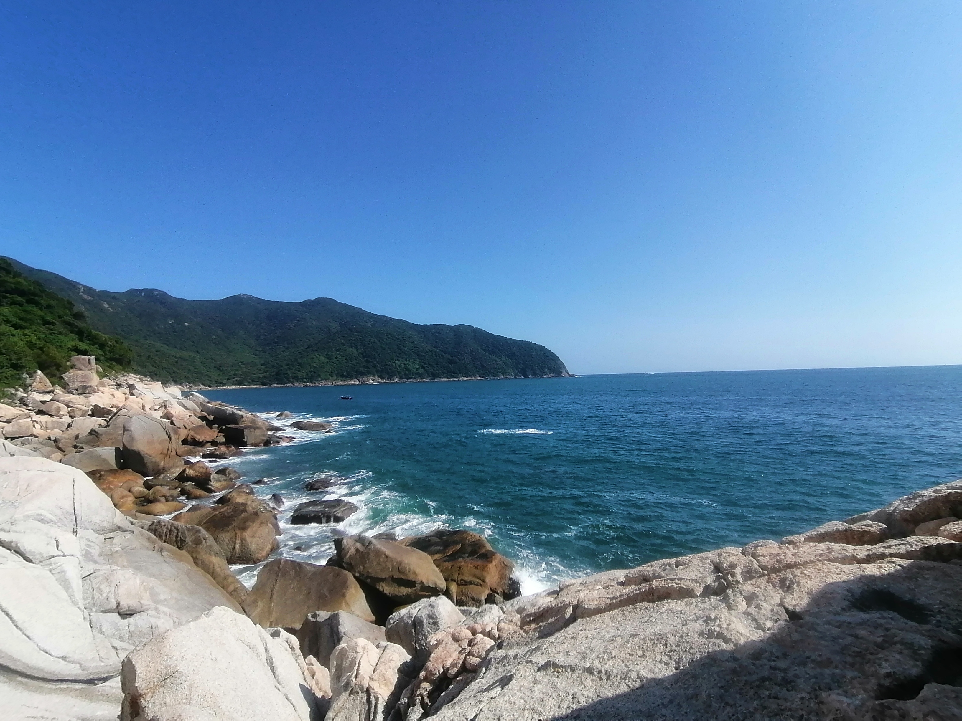
Today, marked a walk starting at 07:30 from Dongchong to XiChong and back, on the DongXiChong trail. I started with Dong (east 东) and ended west at Xi (西) but liked it so much I returned for a second helping of Dong. Like you do. This classic coastal pathway was at times stunning, at other times saddening. The mountains meeting the sea formed a terrific seascape. Clear blue seas and grey skies that eventually turned blue made trekking easier than being under baking sun rays all day.
The nearby Pingshan mountain and a view of Sanmen island did little harm to my vivid impressions of DaPeng peninsula. Cliffs and rock scrambling have long been my thing since experiencing it with Grylls Head outdoor adventure centre and Chapel Street Primary School in year 5. Rocks, holes, tiny islands, bridges, stacks, columns and landforms made by sea erosion towering over sea reefs and the omnipresent imposing tides of an angry sea can’t be a bad day out. It certainly perks your ears up for the cry of seabirds and the crash of countless waves. I wondered, as I wandered, how many stories can each shell tell?
Between the coastal villages of Dongchong and XiChong it is mostly undeveloped, save for the XiChong observatory and three small beach shacks. A few steps and chains have been fitted but nature mostly rules the route. There’s litter, at shameless quantities and annoying spray painted signs pointing out numbers for boats, lodges and so on. I’ve heard it compared and listed as one of the top ten routes in China. Perhaps that needs confirming. Also, that’s a worrying statement about the state of coastal routes. Yes, there are beautiful near golden sands at either village and some great pebble beaches between, but surely there’s more?!
The potential for ecotourism is high provided the litter mountain can be contained. If you can’t carry it back, why carry it there? Discarded wrappers, bags, drinks bottles, beach mats, hats, parasols, gazebos, barbecues and more were seen. Almost all was made in China, so no blame can be sent across the South China Sea. The blowing sea breezes and tides can only be responsible for so much. Humans as a disgrace for the rest. The National Geographic Magazine may need to review their write-ups. Although this walking route is not far from Shenzhen bustling centre, it feels remote and relaxing. Just about two hours from Futian via Yantian port!
16km of up, down, sideways, forwards and back ruined my Altra walking trainers. They’ll need replacing. They’re good for rough wear but not for smartness. This highly scenic route is dusty and tough at times. I enjoyed the 8km walk there and around XiChong so much that coming back made sense. Meeting nobody for three hours on my outbound journey was rewarded with meeting many friendly faces on the return journey, even if I was turned away Mary and Joseph-style by two coffee places in XiChong. On returning to Dongchong a kind shopkeeper pointed me to a shop selling Nespresso coffee. Not a bad end to a walk.
Finishing the day following a video call could only be done one way. Seafood. The local barbecue restaurant was perfect. There’s a few places to choose from. Most feature the animal kingdom, well the aquatic part, anyway. Reflecting on a day well spent, I thanked the trekking gods that I didn’t encounter whatever or whoever left behind all the crap that local village volunteers were bagging up.
再寄 goodbye
XinJiang: Itinerary
你好 / nǐ hǎo / How do, here we go again…
“Hey, are you coming to Ürümqi with me?”, an Aussie called Oliver clamoured. By clamoured, I mean kind of yelled, bawled, wailed or yawped but not in a negative kind of way. You see, Oliver is one of those nice Australian folk who happen to be part human, part megaphone. I don’t think I have heard him whisper. Not once. It may be the only way to get heard over his 21 grade 5 students. I’m not sure. But, anyway, he definitely said it in a voice where people in the far of Dongguan could have heard, or perhaps even the people of Ürümqi heard a little.
We were sat eating ‘shāokǎo (燒烤)‘ and not because barbecue is an Australian’s go-to meal. We’re not reinforcing stereotypes here! It was Friday evening, after school. Laura’s fella was having his birthday and it felt like a good thing to do. A mixture of Chinese, Spanish, French, Moroccan and Venezuelan, American, Australian and British people outside a Xinjiang-family’s restaurant eating great lamb, livery bits and other wonderful breads on a Friday after a long hot week seemed like a good idea. The Wusu beer and Nángbĭng (新疆烤馕 flat bread) went down a treat, following spicy peppers, mushrooms and okra. the chäyza (茄子, qiézi) was a little spicy but pealed away on my chopsticks delightfully. With Oliver’s words in my ears, I told him how I planned to go see my mate Waits up in Gansu province, but it would be a little rushed and not easy to get there and back again.
Having tried to order a rice dish polu (抓飯, zhuāfàn) containing raisins and carrots, I gnawed on meaty lamb skewers (新疆羊肉串) covered in red pepper flakes, cumin seeds and various peppers. The salty taste complimented the juicy flesh well.Oliver growled on, “Come see the Jiaohe ruins, mate.” The Jiāohé Gùchéng (交河故城) ruins have been on my radar for some time.The word mate has been echoing since the day I met Oliver in August, “Would you like an orange juice, mate?” He swiftly blended an orange or two with ice and has been ever-present at school in positive form.And now, after a recent December wander in Yunnan, he’s telling me Piotr and I are being called upon. He’s putting the band back together.
Elwood: “It’s 106 miles to Chicago, we got a full tank of gas, half a pack of cigarettes, it’s dark… and we’re wearing sunglasses.” Jake: “Hit it.” – The Blues Brothers starring John Belushi & Dan Ackroyd
Flights were booked hastily and probably without due diligence. Hand me the international baccalaureate risk-taker profile certificate please, Now, it’s time to book a swab test for the old COVID-19 proof that freedom of travel is okay. Then, there’s the weather. It could be a sandstorm, blizzard, snow, or sunny. Depends on the zone. And because China has one timezone, sun rises later and earlier than here in Dongguan. Next Sunday, sun rises around 07:46hrs over Ürümqi and sets at 20:39hrs. More than an hour later in difference than here in Dongguan! So, I am sat here with about a week to go making a loose itinerary. One that sadly won’t take in the songs of Dilraba Dilmurat. All this information research has happened inside a day. Pages 502-515 of the DK Eyewitness Travel China edition have been read. All this because of Oliver! Not Lionel Bart’s Oliver! Our very own colleague, Áleifr (the name meaning ancestor’s descendent) has set about a trip to a region of Uyghurs 维吾尔/Wéiwú’ěr) people one of China’s 55 officially recognized ethnic minorities. The region itself is a hotbed of multiculturalism and history.
On arriving, as I land in Ürümqi a day before Oliver, because I believe in maximum holiday time, the Xinjiang Silk Road Museum (新疆丝绸之路博物馆) next to the Grand Bazaar at No. 160 Shengli Road should be visited. Here I hope to find more information before Oliver lands on the Sunday, and hopefully catch Piotr up, who will already be there. The lay of the land and a good map may be helpful. My friend Ty, of Murray’s FC. has already said he will put us in contact with a driver and a guide from his home town area. Maybe I’ll look up sand therapy. Sadly, far east of there is Hāmì (哈密), famous for sweet melons of the same name, although the area and its fascinating ‘Devil City’ moniker intrigues. As does the ‘Ghost City‘ around Karamay and Wuerhe.
Nature needs to be seen and the receding faster than my hairline Urumqi No. 1 Glacier (乌鲁木齐1号冰川; wū lǔ mù qí 1 hào bīng chuān) seems to be a good start. Half of China’s 20,000 glaciers are all located in Xinjiang, and its proximity to the peak of Kyrgyzstan-Chinese Jengish Chokusu (托木尔峰) makes sense. That towering peak (7,439 m/24,406 ft) forms the roof of the poetically-named Mountains of Heaven (Tiān Shān 天山) mountain range heavily influences the geology and geography of the whole region. They’re part of the Himalayan orogenic belt so there’s certainly diverse terrain near to Ürümqi. Time spent in one of the world’s most remote and distal (to any seas) shall be a new experience.
At 6000-year old Turpan (tǔlǔfān/吐鲁番), there’s Huǒyàn (火州 place as hot as fire), the Flaming Mountain (火焰山 Huǒyànshān) to the north, an irrigation exploration at Kariz (meaning well) Well (吐魯番坎儿井乐园) and the Sugong Minaret(苏公塔) to the east. The Bezeklik Grottoes could be possible. Then there’s the Apandi people and their Grape Valley (葡萄沟), the Bezeklik Grottoes (Bózīkèlǐ Qiānfódòng 柏孜克里千佛洞), Gāochāng Ancient City (高昌古城), and the Astana cemetry (阿斯塔那古墓 Āsītǎnà Gǔmù). There’s certainly the oasis-village Turoq valley (吐峪沟 tǔyùgōu) 70km away. Travel around the region may be difficult but the lure of rail travel hold strong. Two railway lines pass through the region: 南疆铁路; Nánjiāng tiělù; and one from Lanzhou (兰新铁路第二双线). Seems Turpan will need a few days. And that’s before finding information on Biratar Bulak. I hear this region is often nicknamed as China’s Death Valley. Earth’s second-lowest depression is an incredible 155 metres (509 feet) below sea level! The world’s largest Naan stove sounds more at home in the U.S.A. but can be found at Darwaz. I’ll try and convince Oliver and Piotr to go.
The journey to the west will hopefully meet with less difficulty than the Monkey King met. In Journey to the West, by Ming dynasty writer, Wu Cheng’en, the protagonist met a wall of flames, which was likely at Xinjiang’s Flaming Mountain. Uighur (the people of the region) legend has it that a dragon lived in the Tianshan mountains (south of Ürümqi) but was slew by a hero who had grown annoyed at the dragon’s diets of children. That spawned the dragon blood to form a scarlet clot: eight valleys of the Flaming Mountain. One for each piece of the chopped dragon.
I told Waits that I’d go to Gansu in summer (because the UK is not a viable option) and from there I’d probably head to Xi’an to see the Terracotta Warriors. The armies of Qin Shi Huang really should be marketed to the basketball crowd here. I’d buy a basketball shirt with Terracotta Warriors Basketball Club on it. Maybe I should suggest to T.W.I.S. that Terracotta Warriors International Society would make a good history club. Or perhaps, in summer, I will enjoy the humidity and heat of Dongguan. Nothing is certain, but optimism and positivity being made by our souls. Scatter!
To quote Bugs Bunny and Daffy Duck, “That’s all folks!” That reminds me, I have still never watched Space Jam, and I heard there is a sequel this year!
yǒu kōng zài jù / 有空再聚 / See you soon
Some possible places to stay include the below, just in case somebody needs to see where we can stay. Or not. It seems camping is ill-advised.
Hotels in Urumqi
Bestay Hotel Express Urumqi Hongshan:No.49 Yangzijiang Road, Shayibake District, Urumqi
Bayinhe Hotel Zhongshan:No.71 Wenhua Road, Tianshan District, Urumqi
Sheraton Urumqi Hotel:No.669 Youhao North Road, Sayibake District, Urumqi
Bogeda Hotel: 253 Guangming Road (光明路253号), Urumqi Tel: 0991-8863910
Xinjiang Metian International Youth Hostel: 726 Youhao South Road (友好路726号), Urumqi Tel: 0991-4591488
Pea Fowl Mansions: 489 Youhao South Road (友好南路489), Urumqi Tel: 0991-4522988
Yema International Business Clubhouse: 158 Kunming Road (昆明路158),Urumqi Tel:0991-7688888
Suba Hotel: 140 Gongyuan North Street (公园北街), Urumqi Tel: 0991-5590666
Siver Birches International Youth Hostel: 186 South Lake Road (南湖路), Urumqi Tel: 0991-4811428
Hotels in Turpan
Huozhou Hotel:Shuiyun Square, Donghuan Road, Turpan
Silk Road Lodges – The Vines:Muna’er Road, Muna’er Village, Turpan
Tuha Petroleum Hotel:No.230 Wenhua Road, Turpan
Jiaotong Hotel: 125 Laocheng Road (老城路), Turpan Tel: 0995-8531320
Turpan Hotel: Qingnian South Road, Turpan Tel: 0995-8568888
Xizhou Grand Hotel: 882 Qingnian South Road, Turpan Tel: 0995-8554000
Dongfang Hotel: 324 Laocheng Road, Turpan Tel: 0995-6268228

Yunnan, finally.
Happy New Year. 新年快乐。
I awoke on January the 2nd in Shangri La. The final day of trekking around YuBeng (雨崩) village involved a 500m ascent followed by a 1100m descent to XiDang village. YuBeng translates directly as rain and collapse or avalanche. As Piotr, Oliver and I were ascending we heard a mighty crack in the air and watched an avalanche high on the wide expanse of the Hengduan mountain range. A shelf somewhere near Kawagabo peak slid away. Rather noisy.
On arrival at XiDang, our driver Mr ZhaShiDingZhu (扎史定主), a warm-hearted Tibetan, picked us up. He would take us to Shangri La. Our driver stopped at three historic monuments, two dramatic views and to enjoy a chicken hotpot. It was a good journey indeed. The long road of return was pleasant and a fitting end to a wonderful few days in the mountains. Arriving late to pleasant digs gave us all a chance to rest our weary heads.
A day of gentle cycling and pottering around followed. With hire bicycles from the Boudhi Boutique Shangri La, Oliver and I cycled around old buildings, shops and I stripped down to my underwear as the rear of my trousers underwent a cheeky repair. The shopkeeper wasn’t too perturbed but his wife certainly showed embarrassment.


In Shangri La, Oliver and I bid farewell at breakfast to Piotr. He was off exploring more snow-capped wonders. As he wandered off, Oliver and I meandered and ambled up and down the Shangri La old town. Between gift buying and sightseeing, we ate great Nepali food at the Bohdi Boutique Inn. A most wonderful find. Shangri La beers did their best to quench our thirst and that’s where the trip closed. One simple flight back the next day and we were back to Guangdong. Yunnan was far away but close to my heart.
So, what now?
Firing into 2021
新年快乐。Happy New Year.

Sat eating our selection of dishes, people were drifting by the window in small groups. Sometimes one or two. Sometimes ten strong. Our dishes featured Tibetan pork, eggplant, potato in some shape and form, lovely eggs, and various vegetables cooked to perfection. Our New Year’s Eve selection was delectable. Piotr, Oliver and I supped Shangri La Beer local lager and nattered away carelessly. By 10pm, Oliver was flagging by the hot stove and Piotr was busy on a phone call. I suggested Oliver can sleep as nothing seemed to be happening. Soon after we all decided to go and get some fresh air. And beer. Mainly the beer.
With our carrot dangling before us, we set off like donkeys on a mission. We briefly called into a neighbouring hotel/KTV bar before watching a party there. It was rather boisterous and loud but not our cup of tea. The warm stove was welcoming but the floor beneath it rocked precariously. Off we set to the Yak Butter Inn, and the many cats within. Here the boss welcomed us but a group of footbath users were less than warming. The cats wandered around, greeting us with gentle mewing and meow sounds. A beer sank ever too easily and we strolled back to our lodge. Still people passed by heading to the upper part of Upper YuBeng.
After another beer at our lodge;curiosity swung it’s hands at us. We followed the now more frequent groups heading to the upper limits and temple area of Upper YuBeng. Off we trotted. Here, by Upper YuBeng’s main stupa, a group of a few hundred people were doing their best to resemble Chinese druids. A swelling and pulsating circular throng of people moved around to no particular beat. Some instructions by people in the middle rang out. A central fire, with warmth attracted Piotr and Oliver. I stood around the edge trying to make sense of it all. As 2020’s final minutes arrived, a ripple of excitement charged through the gathering.

A girl from Beijing grabbed my hand and explained the proceedings. Sparklers, countdowns and fireworks with some local dancing. And that’s almost what happened. Some of it was wonderful, other bits disorganised and cumbersome. Either way it was a welcome surprise and a great experience to share the welcoming of 2021 with trekkers, some local Tibetan people in modern takes on traditional headwear and attire. I never thought I’d see Apple-brabded Yunnan clothing. This is China, after all. Everything is possible. The next morning involved Tibetan pork, eggs and Tibetan bread for breakfast. Well if you’re heading off, head off on a full tummy…

Happy New Year for 2021.
Idyllic Wild
新年快乐!Happy New Year!
The road from Feilaisi (飞来寺) is long and winding, with concrete under foot or wheel. Towering on the opposite side of the valley is Kawagarbo (6740m) and Yunnan province’s highest point. The roads bend and wind up and down to a checkpoint. At this point, one must surrender 27.5RMB. This gains you access to the Yubeng village scenic area (雨崩村). Starting an ascent at Xidang Spring (西当温泉), my colleagues Javier and Carmen headed up alongside me. We were to follow a trail marked by green bins. The spring of the village was rather an anti-climax.

Those green litter bins and new saplings littered the pathway upwards. The path would zigzag across numerous dirt tracks and one under construction concrete road. For the entire ascent, I stopped only once for hot milk and some water in a tiny rickety-old-shack. The pleasure cost me a staggering 130RMB. The man had seen me coming. Each half litre bottle of water was 10RMB and the milk was 110RMB. The man charged 200RMB for noodles to a group calling by. In the future, always enquire about prices before accepting goods. I did wonder how at least 500 noodle pots stacked up at the wooden lodge’s side hadn’t improved the roughness of the building.
The route up had a positive gain of over 1100 metres. At its highest point, my lower legs enjoyed some much needed respite. At which point, a Snickers chocolate bar, not my favoured choice, tasted marvelous. I’d passed through some great panoramic viewing points before reaching Yubeng Upper Village (雨崩上村). Nazongla Yakou (那宗拉垭口) wasn’t too dramatic, but the views on entering Yubeng certainly brought a beaming smile to my face. A good 6 hours from Xidang to YuBeng was needed. On arriving, I checked into the Yak Butter Inn.
The Yak Butter Inn has a flowery name. It should be renamed to something feline like a cattery. The lodge has numerous large moggies strutting around. Young long-haired fuzz balls can be seen curled up in various baskets and cushions. A lone dog limps around, evidently resigned to being shy of any further pack members. The pleasant warmth of a wood stove heats one corner of the room, as the sun licks through windows at another. A busy kitchen emits fragrances of common Chinese cuisine and piping hot teas. A young cat thwacks my leg with its paws seeking attention.

I elect to stay at the Yak Butter Inn for one night. A night in a shared dormitory reminds me that I no longer want that kind of experience. Farting, belching, snoring and a roundabout of lights-on, lights-off motions are one thing. Hearing Douyin/TikTok at every hour is another. With my colleague Oliver and his entourage arriving the following evening, I changed lodges. Two nights later, we changed lodges again. No rooms at the second inn, due to New Year bookings. The kind Tibetan owner had served us great Pu’er teas (普洱茶) and good hearty hiking food.
Before Oliver arrived, Carmen, Javier and I wandered upwards to the Sacred Waterfall (神瀑). A gain of 600 metres altitude. It being winter, the waterfall was mostly frozen and receding. The valley walk up from Yubeng Lower Village (雨崩下村) was gentle with a solid pathway built to guide tourists slowly in one direction and back again. CCTV and Chinese good luck shapes marked the route making it impossible to go off the beaten track. Walking poles needed a soft base and were generally of little use. The five hour round trip was pleasant enough with sweeping chains of prayer flags coating the latter stage of the route. Overflowing green rubbish bins and hundreds of scattered Red Bull drinks cans added shame to such a holy route. Chipmunks, adventurous and cute, sought treats amongst furry green moss-coated ancient trees. The cool fresh air a certain reward for stretching your legs out.

Prior to walking up the valley, our trio had a few jumps and twists around the flowing streams that sit just above Lower YuBeng. The great boulders and pebbles are home to a logging camp which causes the water channels to splinter like roots from a tree. The transition into the old woodland beyond is chilling and in the shadow of the mountain. Like many places, frozen snow regulates the ambient temperature, giving a dark murky cool feel. It wouldn’t be a surprise if Master Yoda lived here. An icy world in opposition to the sun dried bank over the gentle flow of the stream. Perfect for Jedis in hiding.
A six to seven hour walk from Yubeng Upper Village (雨崩上村) via Xiaonong Base Camp (笑农大本营) gets you to the cold dry icy landscape of the Ice Lake (冰湖) at 3900m, nestled beneath Kawagarbo. The great overhanging peak condensed with snow from seasons of snowfall and heavy wind looms overhead. The wind reminds you of nature’s power, driving in, swirling and biting sharply. Remnants of receding glacier shelves and loose looking snow shelves linger menacingly. They will fall one day. The Ice Lake lived up to its name. Some of the ascent (around 800m gain) that day necessitated crampons. My tough boots bore the brunt of careful footwork and one walking pole, as I climbed the challenging route. No crampons for some. The donkey tracks and frozen soil pathways before it zig-zagged up and down various forestry climates battering my boots into disrepair on the return journey. Rhododendrons, pines, cypress trees and other green species reflected various browns, reds and greys. It was a real rainbow of a route.

Mother Nature has been busy here. The valleys around YuBeng are dramatic. They’re microclimates with epic visual proportions. Each has a mysterious feel to which evidently religion has become attached. They’re places of stories and tales, entwined to folklore and legend. As a devout daydreamer, they’re a place to let the mind go and wonder as you wander. Every twisted tree, shadowy rock or distant sound could start a new story. Farming, the traditional Tibetan ways, mixes with a blend of the modern and the local wooden builds make way for tourism-aimed metal and concrete lodges. Glamping has arrived, but the Tibetan pilgrimage routes remain. New stories will yet be told.

Beyond the idyllic setting of managed walking routes, it’s possible to trek along an ancient Buddhist pathways. That pathway leads to a glacier, snuggled beneath Kawagarbo. Remembering that climbing the mountain is banned and ill advised, it’s possible to follow an ancient trail through woodland, across a grass plain into a kind of Alpine tundra. The evident altitude cools much of the area and ice watetfalls, streams and ponds are frequently found higher up. The thickness of mosses, lichens and bearded trees drape on wilder routes. The mountain hinterland maintains a natural ecological state, and away from the beaten track, it’s the best place to witness it. Leave only footprints. Certainly don’t attempt the long walk to Myanmar. But enjoy the diversity of fungi and lichens.
The Northwest of Yunnan has quickly become my favourite place in China. YuBeng is itself a piece of heaven on Earth. Perhaps the nearby city of Shangri La should hand over its adopted name to the village of YuBeng. This growing tourist hotspot will see many pilgrimages, changes and challenges in the coming years. Will it sustain its beauty? Only time and UNESCO status will tell. I was told around twenty households made up YuBeng in the last decade. Now, there’s a Guangdong restaurant, Hong Kong style guesthouses, plenty of Sichuan options and even a family from Shandong (Eastern China). It will be tough to retain the Tibetan charm and character. Like much of the world, this corner of Dêqên is becoming quite samey-samey. The same old KTV can be heard by a shattered water prayer wheel. Up the way, steamed Cantonese food can be ate, with an ancient Stupa baked under a solar powered streetlight. Mani stones hide behind new hotel signage. The old ways are slipping from sight.
I’ve experienced a little altitude sickness, for most of the region is over 3200m. Discomfort in sleeping for the first few days, some muscle exhaustion, breathlessness at times and minor headaches resolved mostly yesterday. Enough so to enjoy a light Shangri La Beers lager or two, with delicious fresh yak meat, at the insistence of our lodge owner.

This morning when I walked into dining area of the lodge, I thought the weather-beaten looking Tibetan men had all had an argument. The dozen men, that seem to be ever present within the lodge (under renovation and expansion), were sat one per table at various parts of the room. On getting my door key, I spied that they were all head down and deep into Mandarin Chinese writing and reading textbooks. I left them to study in peace, passed the hanging yak meat, locked my door and joined Oliver, Piotr and Benedict for breakfast at another lodge.
Piotr works for shell. Oliver had met him and others on the way up from Xidang. Sociable Oliver teaches to travel and travels well, making friends as he goes. Knowledgeable as he is, he can be a little loud, as is the Australian way for many. He’s a sound lad with a keen eye to see more, do more and learn more. It’s a pleasure to have him as a colleague at Tungwah Wenzel International School. He met Piotr and you’d think they were best friends. It’s pleasing to see. The two entered the ice cave, skidded on the ice lake and galloped up the glacier together. Some people are more astronaut than astronomer. I’m happy flirting between active and observer. The mountains are familiar and here I feel relaxed. Wandering around watching jays feeding in the undergrowth satisfies me just as much as ascending ridge lines. We did enjoy a little camp fire and tea though.

Sat reading Roald Dahl’s Someone Like You, on a moss covered rock, shaded from the bright sun, as it dropped below the mountains overhead will no doubt remain my favourite place to read for many years. The gentle stream underneath that feeds into either of the three great rivers makes me feel dreamy and sleepy. The Jinsha (later Yangtze), Lancang (later Mekong), and Nujiang (soon to be known as Salween) rivers come from the Qinghai-Tibetan plateau. People from roughly 22 ethnic groups (Naxi, Lisu, Tibetan, Bai, Yi, Pumi, Nu, Dulong etc) live in and around the starting areas of these great rivers. One drop of rain water into this relatively narrow area of basins could end up in the Andaman sea by Myanmar, or flow by Vietnam’s Ho Chi Minh City, or slip through Tiger Leaping Gorge towards Jiangsu and Shanghai. I look up from my book, watching a clump of ice break up and drift downstream. What a pleasant little journey.
Until next time…


Farewell 2020. Happy New Year.
Dear all,
All the very best for 2021.
Let’s not dwell on COVID-19 and it’s terrible spread throughout the globe. It’s been a challenging and upsetting year for many. The less said on this eve of a new year, the better. Stay positive.
With trips to Nepal, Thailand (as a Corona refugee), Suzhou and now Yunnan, I’ve been lucky to experience a variety of cultures and religions in different shapes and forms during 2020. All have stood the test of time and all have stories about being adaptable. 2021 for the human race will be no exception. I’ve been lucky to get some travelling in, during this new norm but unlucky not to travel and see loved ones. The future is tingling with uncertainty but when a reunion comes about, I’m certain it won’t be wasted.
Climatic change, political indecision, blundering idleness by an impenetrable elite, racism and divide, disease and worry. Twenty twenty’s themes will carry on into this year as we all live as best we can. The gloom of a serious Sir David Attenborough message should stay with us. As should Amnesty International. Black Lives will always matter. #MeToo? Where changes are needed things will always need to happen. Vaccines and immunisation can only cure so much.
2020 allowed me opportunity. I’ve been blessed to start work at Tungwah Wenzel International School. A few weeks of expensive quarantine and drastically overpriced return flights got me back into China, as others faced even tougher routes to work or pathways no longer open. It’s been a good ride at work so far. I can only see it getting better.
Football for and with Murray’s FC has provided a regular escape from a landscape tinged by trepidation. Having also joined Dongguan Bulldogs, for a few games of tag rugby, and several solo bike rides, freedom has been a privilege.
I’m writing from a cold bed in YuBeng village, Yunnan, China. I’d like to write more but like the new journal in my bag, there’ll be plenty of opportunity and positive days ahead for the writing of new well remembered days. All the best for 2021. Keep hope in your head and heart.
Peace and love x
Tashi Delek
Tashi Delek / 你好 / Hey, hey!
It was Christmas Eve and I enjoyed scrambled eggs, with toast and cappuccino. I decided to have an easy day of wandering. To acclimatize to altitude is important. I drank ginger tea, water and ate bananas with other dried fruits. Other tricks include walking high and then sleeping low. So, for Christmas Eve, I looked for a bumpy mountain. I had my eye on a few peaks around this valley that envelopes Shangri La city. The cold was manageable with a City shirt and my trusted Sherpa jacket. The Italian wool socks were and are highly effective too. Nighttime hit -12C outside but inside a Green Tree Hotel it was standard room temperature.
Following a late breakfast at The Compass, I headed to LánYuèGǔ (蓝月谷) which translates to Blue Moon Valley. It’s real name is Shika Mountain (石卡山; Shíkǎshān) and it towers to the west above Diqing Shangri-La Airport (DIG). The airport is at at around 3280m. I was able to wander up to about 3500m, way shy of the peak towering above. There were too many people saying, “You shall not pass.” Strong winds had closed the nearby cable car and every path upwards. Rules is rules. I headed back and spotted some cranes, a photo opportunity or two and plenty of construction. Some splendid stupas and magnificent views made for a pleasant wander. Blue Moon wasn’t all that, but the name belongs to City’s chant so what’d you expect?
In the evening, I enjoyed local Tibetan food and hospitality before heading back to rest. I woke up in the same Green Tree hotel, opposite the city bus station. At 08:20, I was on a bus headed for Déqīn town or city. Unsure what it actually is. From there many trails lead off to waterfalls, glaciers and villages. This area is spelled as Diqen, Díqìng and Deqin (བདེ་ཆེན་རྫོང་). It’s rather confusing. Since Tibet handed over Kham province to Yunnan province, it’s become autonomous (迪庆藏族自治州). The many names should be a starting point for a clear up. By noon, after a climbing route of a road trip, the bus pulled into Deqing city’s bus station. Here I was told that I could go onto Feilaisi (飞来寺) village. I agreed and returned after a quick lunch. Less than an hour later and the bus halted outside a terrace of hotels. Opposite stood a rather imposing two metre wall. Beyond that wall, a view to a kill. The picturesque and snow capped range of MeiLi Snow Mountain (梅里雪山).
After a few minutes standing outside I checked into the a catching named hotel, Deqin Snow Mountain Town Tourist Reception Center (No.2 Reception). I couldn’t find the sequel. After dropping my bag up four flights of stairs, I grabbed my camera and crossed the road into the Mingzhu Langka Viewing Platform, and following my health code check, I was away to wander and enjoy the view. The panoramic settings on cameras was made especially for this kind of scene. The clear air, beautiful blue skies and Lancang river valley below only added to the dramatic setting. A main deck with 8 stupas, a rare Mani wall, and an abundance of prayer flags made my Christmas Day special in ways I hadn’t previously imagined.

The fluttering sound of prayer flags, slapping each other, and spiraling up and down on winds with the fragrance of incense and juniper took me moments to clear my mind. The overwhelming scenery had swallowed me up. With each majestic cloud hovering like a pirouette over the many peaks, it was easy to catch my jaw falling lower than usual. The interjection ‘wow’ felt seriously below par, yet it flew out of my mouth with consummate ease. The main peak, Kawagarbo, is 6740m up. Tibetan people refer to it as Nyainqênkawagarbo. It’s a hugely sacred mountain and climbing is banned. Climbers have tried and in 1991 it claimed 17 members of one expedition. It is a sinister and magnificent looking mountain range with twenty peaks, of those 6 tower over 6000m. Tibetan pilgrims cover a different distance each year, circumambulating 240km (150 miles) around the mountain base, praying to the warrior God inside the mountain. This UNESCO World Heritage Site has a real spiritual ambience. I’d look upon the framed snow peaks on both Christmas Day and Boxing Day in wonder. Absolutely stunning.
On Boxing Day, my light stroll rewarded me with views of at least ten vultures and different angles of the mountains over the raging river below. Dinner was nothing to shout home about but the oranges and pomegranates around Feilaisi certainly need a positive mention.
The walk goes on…
